Cold With Snowy Chances Until February
Find Eric Fisher on Twitter and Facebook
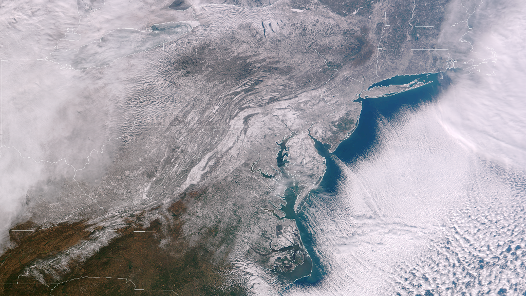
A beautiful satellite image released by NOAA today, showing snow coverage over the Northeast after the Tuesday/Wednesday snowstorm. Note the coverage all the way down into North Carolina! There are also beautiful cloud streets stretching out over the ocean due to cold air rushing over the open water. You can even spot the little 'tail' of clouds poking into Delaware Bay, following the topography.
Upon first look at the headline for this blog - you might be saying 'uh, yeah. It's January.' But in recent years it just wasn't the case. Last year at this point we had less than 8" of snow in Boston and both December and January ran WELL above average for temperature. The year before, we only saw 9.3" of snow all winter and were playing golf in January!! So certainly compared to recent history, this has been quite the wake-up call. This past December ran -1.4º below average, and while January is about dead even for the month, it will end up much colder than average thanks to this streak laid out ahead of us. And for snow - more chances to come shortly.
In the here and now we've got our hands full with some bitterly cold air. It doesn't feel *too* bad during the middle of the afternoon with the sun shining (and rising ever higher in the sky for longer periods of time), but it's pretty rough during the nights and mornings. Many towns go subzero to just a few degrees above tonight, with crystal clear skies. If you're into stargazing - bundle up and enjoy! Crisp and clear with barely a speck of moisture in the air. A still active breeze at times will bring the wind chill down into the -15 to 0 range through the early morning hours on Friday.
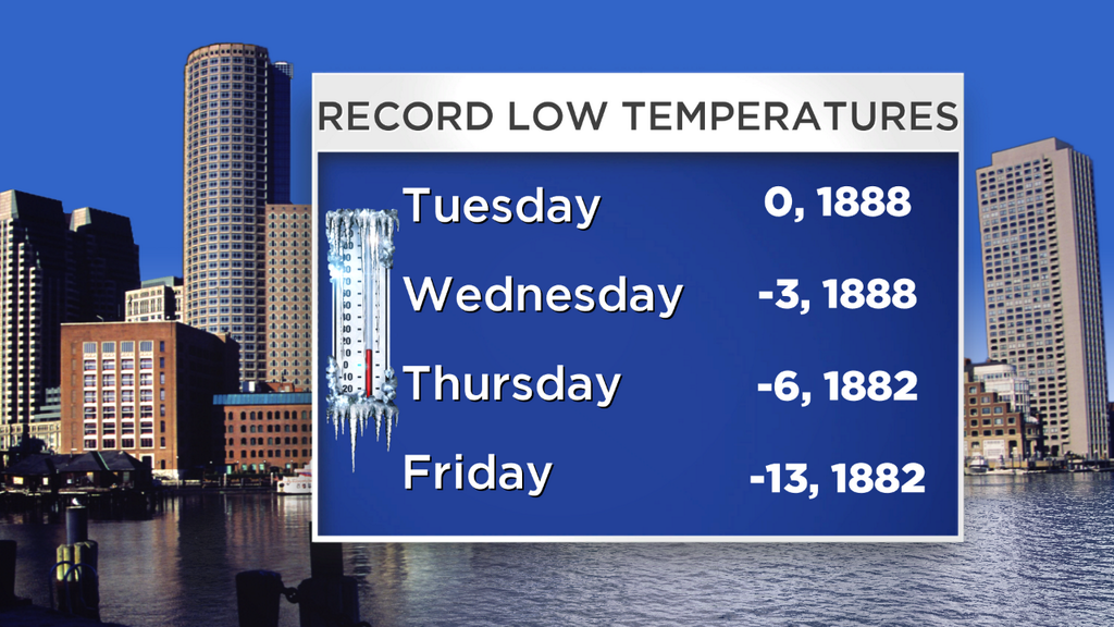
The record lows in Boston for this week go back over 125 years, and we haven't been close to any of them.
As cold as it is, we're nowhere near record territory. Friday's record low is also the all-time record low for the month of January in Boston, sitting at -13. There's a bit of a loophole here - the climate site used to be in the city back in those days and not on the water at Logan, plus the urban heat island effect was much less. Even still, downtown Boston won't even dip below zero tonight. Tomorrow will feature ineffective sun with highs in the 10s to near 20. With the wind, you're talking a 'feels like' temp in the single digits. But at least it's Friday!
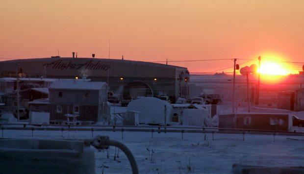
From the 'could be worse' files. This is the first sunrise in Barrow, Alaska since November 18th. Barrow is the northernmost town in the U.S. - and goes dark during the deep winter because it's inside the Arctic Circle. The sun was above the horizon for a whole 23 minutes on Wednesday. Source: Alaska Dispatch
Heading into the weekend I'd be lying if I said us local Meteorologists didn't have a little apprehension! After last Saturday's sneaky snow - we're all on guard for this approaching front. Snow showers are certainly likely, and it may come down heavily for brief amounts of time if some squalls can develop. So far as I can see now, we could be talking a coating to up to 3" of snow. Not huge, but still a factor for traveling at times. Most of that activity should be in the afternoon. If a wave of low pressure can develop on the front and enhance snowfall we could get a bit more. Looks unlikely for now, but check back in for updates.
There should be some pretty gusty winds out of the southwest ahead of this front, too. So even though this is our best shot at going above 32º for the only time until February, it may feel quite a bit cooler. Boston and points south and east should be able to climb above the freezing mark, but areas to the north and west may not be able to manage it. Great for ice hockey enthusiasts, not so great for the home heating bill. This front will bring a renewed blast of cold for Sunday. We'll barely get out of the 10s, and some towns won't even manage that!
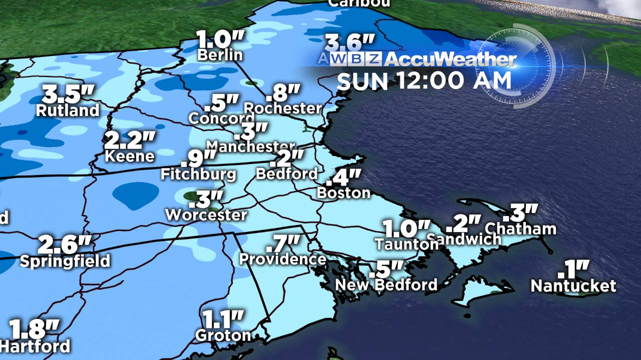
This is just one models depiction of how much snow may fall on Saturday. These projections change from run to run, but I think this paints a pretty accurate picture. A widespread coating to 3" looks likely, as things stand now.
In the fast jet stream flow another clipper will come through late Sunday night into early Monday morning. The current track of this system takes the low up through New York State - not typically much of a snowmaker for us. If that track shifts a little southward we could be talking about an increased chance of snow. But for now, it looks like a mild event with just a little to contend with in the overnight hours. Behind that system - you guessed it - more brutally cold air! This batch may be the cherry on top of a long stretch of cold.
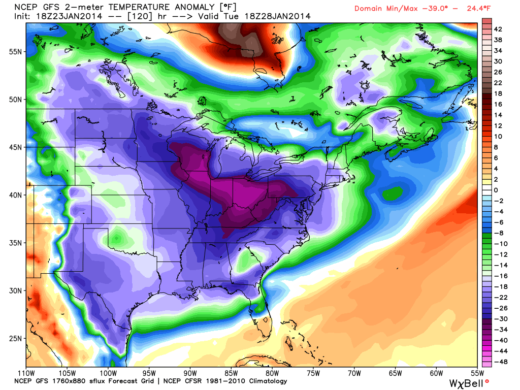
GFS forecast for surface temperature departures from average next Tuesday. Below average for everyone east of the Rockies, in some cases 40º below average! While no model is perfect 5 days out, this signal has been there for quite a while and it's pretty much a lock that everyone will be looking at *very* cold air again. Source: WeatherBell
The setup across the Nation by Tuesday looks pretty wild. If all pans out, it will be so cold that the 540dm thickness line will be out over the Gulf of Mexico, snow may accumulate in the Florida Panhandle, and much of the U.S. will be under a deep freeze (even colder than the one we're in now). It's looking like this may be the last hurrah in what's been a brutal stretch for much of the Nation. Tuesday looks frigid again here, but the interesting part comes on Wednesday. As has been the case a couple times already this season - models are hinting at a storm forming along the leading edge of the Arctic air. It's being pegged just out-to-sea for now, but it's close enough to be watched carefully. The overall flow, especially the way the ECMWF sees it, is conducive for grabbing a lot of moisture and bringing a low up the coast. If it comes close enough to us, it's the type of setup where we could be buried. Of course - it's still 6 days out and all sorts of things could change. But certainly something we'll be monitoring as it's our next chance for truly significant snow. After that - a bit of a thaw looks increasingly likely as we head into February!
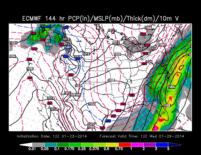
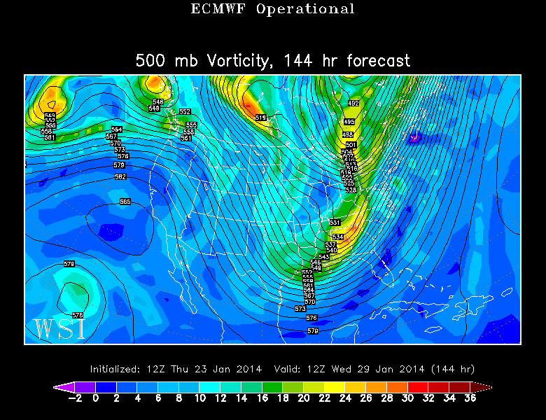
ECMWF forecast for Wednesday morning - lots of moisture coming out of the Gulf. Also pictured the 500mb flow with vorticity. Phasing potential? Source: WSI Energycast
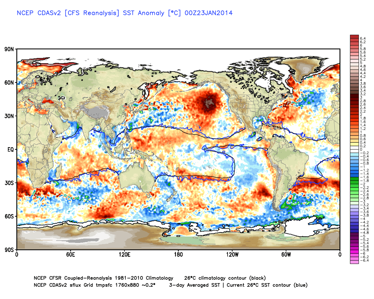
A lot of people are asking 'What's going on?' with this recent stretch. There are a few factors out there - and in weather it's often a lot of 'chicken or the egg' when it comes to describing how things happen. Which one causes the other? But we know that certain things tend to go together. Right now, we're in a cold PDO (Pacific Decadal Oscillation) phase. Below are SST (sea surface temperature) anomalies. Notice the huge bulls-eye of above average temperatures in the Pacific, with a rim of cooler than average water along the West Coast and up toward Alaska. This is the signature of a cool PDO. PDO phases typically last a long time (a decade or more, as the name suggests). One characteristic of a cold PDO in winter is very dry weather along the west/southwestern U.S. - which is exactly what we've been seeing.
At the same time, the Arctic Oscillation (AO) has bee negative for almost the entire month. Below the phase is pictured over time, and you can see there's just one peak in this past month. That peak is when we were all enjoying a nice thaw last week, as the AO went positive. What is the Arctic Oscillation? It's a measure of how winds are traveling at high altitude around the pole. When the AO is positive, a tight band of strong polar jet stream winds flows around the Arctic, bottling most of the frigid air up to the north. But when it goes negative, the polar jet weakens and becomes more disorganized. These wobbles of the jet that form troughs, also called Rossby Waves, basically leave the freezer door open. The coldest of the cold air comes southward, and lately one of those semi-permanent dips has been over the central & eastern U.S.

Recent AO and forecast looking ahead. Source: WeatherBell
Looking for some relief? There may be some in sight. Most models are pointing toward this pattern breaking down somewhat by the start of February. If it pans out, that would finally bring some moisture to the drought-ridden West Coast and allow temperatures to moderate some in the eastern U.S. While it may not be a full-fledged warm-up, any period of time that goes a little above average would feel very nice compared to what we're living with now!


