Storm Update: Snow To Continue Through Wednesday Morning
BOSTON (CBS) - No two storms are alike and there is no such thing as the perfect forecast…rules for a meteorologist to live by. As we get deeper into this nor'easter, we are now adjusting the forecast a bit in some areas.
Snow Amounts
North and West of 495:
There is a very sharp cutoff with this storm between the haves and have-nots and this area is definitely in the have-not section. In fact, there will likely only be a dusting to a few inches total from the whole event…strange, the area that typically gets the highest snow amounts, nearly getting shutout with this one…
Boston area, nearby suburbs, Metro West:
6-10" still looks like a good bet for Boston and surrounding towns. The exception will be to the south and west in Norfolk County as well as northern Bristol and Plymouth Counties where a heavy band setup early on and didn't want to budge. It is classic, happens almost every storm…there is an area where strong, localized banding occurs, last storm it was in Essex County. No doubt many towns underneath this heavy band will top a foot of snow, perhaps reaching as high as 15".
Check: Current Conditions | Interactive Radar | WBZ Weather Blog
Southeastern MA, Cape Cod & Islands:
This was where the early forecasts had the jackpot and it still may happen. They got off to a slow start and will need to play catch up later tonight and Wednesday morning. The snow will last the longest down there, not tapering completely over Cape Cod until Wednesday afternoon…so the forecast 10-15" of snow is still possible, but most towns likely on the lower end of that range.
Check: Latest Snow Totals
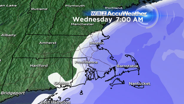
Timeline
The back edge of this storm will be playing games all night long, but for the most part the snow will continue to fall to the east of 495 through Dawn…Boston will likely taper off between 7 and 9am…The South Shore tapers between 9-11am…Cape Cod and the Islands don't completely stop snowing until later Wednesday afternoon.
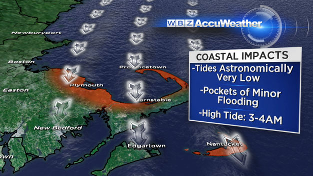
Winds/Tides
The wind will be shifting from north-northeast to north-northwest by Wednesday morning. Gusts will generally be between 20-40mph, perhaps a few reaching 50mph on the Outer Cape. Certainly not enough for any significant wind damage, especially given the light and fluffy nature of the snow. No serious Coastal issues with this storm, tides are at their lowest astronomical point of the month.
Cold
This will be the story long after the snow has ended…it is going to remain below freezing for most towns in Southern New England until sometime next week! Boston may just nick the freezing mark on Saturday, but otherwise temperatures will remain in the teens for highs for the next several days. Wind Chill values on Wednesday will stay below zero all day and reach as low as -20 at times.
You can follow Terry on Twitter @TerryWBZ