Arctic Temperatures, Clipper Storms Move In This Week
BOSTON (CBS) --- January 20-25th are typically some of the harshest, coldest days of the year. It is truly the dead of winter and while days are starting to get a bit longer, temperatures on average, tend to bottom out during this week. Unfortunately this year will be no different, in fact, it will be even more cold than normal, perhaps nearing record levels.
Check: Updated Blog For Tuesday's Storm
Watch Eric Fisher's Latest Forecast
The overall weather pattern this week and perhaps into next week as well, will feature a very dramatic jet stream across the United States. A giant ridge will build in the Western half of the country, basking much of the West Coast in warm, dry weather. This isn't necessarily good news for California, as their year-long drought will only worsen. The jet stream will take a huge nosedive through the upper Midwest, Ohio Valley and eastward to the Mid Atlantic and New England. Yet another blast of bitterly cold, Arctic air will pour southward later on Monday.
Check: Current Conditions | Interactive Radar | WBZ Weather Blog
A Winter Storm Warning is in effect for Eastern Massachusetts from Tuesday afternoon until Wednesday afternoon. A Blizzard Watch is in effect for the Plymouth County Coastline, Cape Cod and Islands.
Once we drop below freezing Monday night, there will be no going back until next weekend. All of New England will be sub-freezing Tuesday through Friday, daytime highs will struggle to climb out of the single digits by Wednesday and Thursday, only topping out in the teens in Boston and nearby 'burbs. Overnight lows will dip below zero for many cities and towns Wednesday and Thursday morning, perhaps challenging some long-standing records
Here are the record lows for Boston this week, you will notice they were all set well over 100 years ago:
Tuesday: 0, 1888
Wednesday: -3, 1888
Thursday: -6, 1882
Friday: -13, 1882
By the way, I am sure you will hear the term "Polar Vortex" again this week...this seems to be the latest fancy weather phrase being thrown around. The fact is, the Polar Vortex has always existed, it is there every winter, and really isn't any more significant this year than most. The Polar Vortex is essentially a fairly persistent area of low pressure (pretty large) which wobbles and rotates around the higher latitudes, near the North Pole. Many times during the winter, a spoke of this vortex will break off and head southward, bringing a taste of the Arctic down to our latitude. This is what happened earlier in January and this is again, what we will face this week. This Polar Vortex 2.0 version (this week) will not be as harsh as PV 1.0 earlier this month, but it will still pack a serious cold punch for just about the entire Eastern half of the Country.
So, while it would make for a great title to a disaster movie or perhaps a name of an evil weather villain, the Polar Vortex is truly nothing new and really isn't completely descending in its entirety down from the North Pole to New England.
So that's the deal with the cold...now on to the snow.
Another benefit or drawback (depending on how you look at it), to this amplified jet stream is a very active storm track. A series of small storms, called "clippers" will ride the jet stream out of Western Canada and move quickly from the upper Midwest off the northeast coastline. For the most part, these storms will remain very weak and somewhat moisture starved. But, the catch and complicating factor for us here in New England, is the Atlantic Ocean. As these clippers hit the relatively mild Ocean water they get an instant infusion of energy, kind of like a morning cup of coffee.
So, our task this week will be to try to determine how much of this storm intensification will happen, how quickly it will occur, and how close to our coast it will be. This is a very tricky forecast and after the poorly forecast snow many got this weekend, I doubt many of you are up for any more weather surprises.
Our first shot at snow comes Monday night along with the leading edge of Arctic air...this would just be some flurries or perhaps a snow squall, not a storm by any means.
There will be two clippers to watch this week, one centered around Tuesday evening/night and the next on Thursday. Weather models are having a hard time forecasting how much snow, if any, we will see from these storms, but it certainly appears that the best chance of accumulating snow will be in southeast Massachusetts, including the Cape.
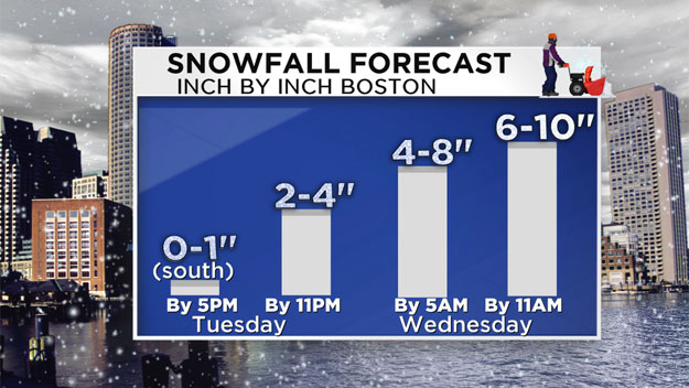
As of this writing it looks like our best shot at a significant, plowable snowfall will come on Tuesday evening and Tuesday night. Snow should begin along the South Coast, Cape and Islands first, just after 4 p.m. It will likely spread to the north and west during the evening…heaviest will be in southeastern Massachusetts. Snow will continue overnight and into Wednesday morning, not completely shutting off until around noon over Cape Cod.
Snowfall amounts… 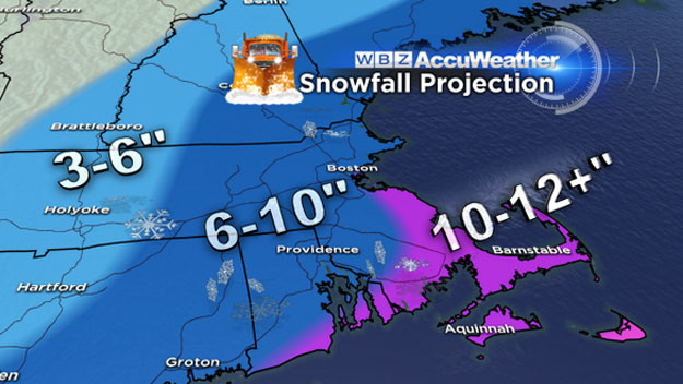
Around 3-6" in Central and Western Mass.
6-10" in Eastern Mass.
10-12"+ over southeastern Massachusetts, Cape Cod and the Islands…
This will be a very light and fluffy snow with temperatures only in the teens during the event. Winds will be a bit gusty out of the north-northeast during Tuesday night and Wednesday AM…20-40mph with some higher gusts near the Coast and especially over Cape Cod.
No coastal flooding concerns as tides are astronomically low.
We will of course keep you updated all week-long here on CBSBoston.com and on WBZ-TV and WBZ NewsRadio 1030.
Stay Warm,
Terry
You can follow Terry on Twitter @TerryWBZ


