Another Very Cold Snowstorm Ahead
Find Eric Fisher on Twitter and Facebook
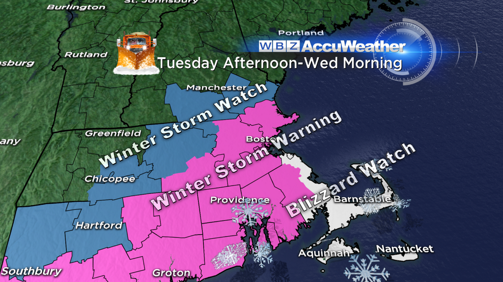
A smattering of Watches & Warnings, including a Blizzard Watch, are up and are always subject to change. These are issued by the National Weather Service Office in Taunton, MA and you can get the latest by click the link above.
I hope everyone had a nice time during out break from truly cold winter weather. As a runner, I know I sure did! The absence of snowy sidewalks or bitter wind chills was a pleasant reprieve. The thaw last week actually brought the monthly average temp in Boston up to 30.7º, +1.6º above average! Once Monday's temps are added that departure will be even warmer. But I assure you, this will not last in any way, shape, or form. January 2014 will go down as a much colder January than the norm as a bitter stretch is laid out before us all the way through the start of February.
The Setup...
A good storm needs some cold air to get the party started, and we have just that heading on in. An Arctic Front is passing through this evening and bringing scattered snow showers and squalls along with it. These squalls briefly brought down visibility and coated the ground in the Berkshires and Worcester Hills. There were even a couple lightning strikes near Springfield earlier this evening! But that's all drying up and the story now is the cold air following. By Tuesday morning, most towns will be in the 0s and 10s (a little 'milder' for the Cape & Islands). This sets the stage for another much colder than typical storm for southern New England.
Timing Out The Snow...
No issues for Tuesday morning as many head back to work after the MLK holiday. And even as we head past lunch, there should be little, if any, snow activity. The one area to watch will be SE Mass where some ocean effect snow may precede the main event. Around Boston, the first light flakes may being somewhere between 3pm and 6pm. So if you're not a fan of winter driving at all and don't want the stress, it may be best to leave work a little early. As it stands right now, it doesn't look like early dismissals will be necessary for the majority of the area. But that's a call that Superintendents can hopefully wait for the morning hours to make.
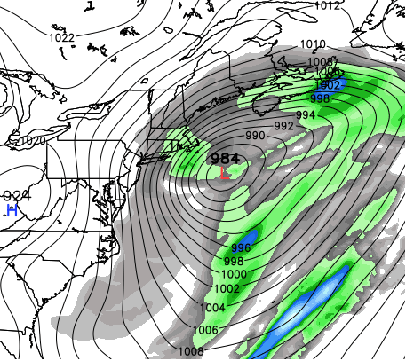
Monday 18z GFS forecast for storm by 7am Wednesday morning. This will be a powerful Nor'easter passing just SE of the 'benchmark' (40N 70W). It's a pretty ideal spot for significant Boston area snowfall, and since it will be a deepening storm there will be strong wind gusts to boot. Source: WeatherBell
Snow intensity and coverage will pick up as the storm deepens to our south during the evening, particularly between 5pm and 9pm. Travel conditions will go downhill, and it's the overnight hours into Wednesday morning where the meat and potatoes of the storm will occur. Like we saw in early January, snow ratios should be very high. We could be talking about 20:1, for much of the interior, and at least 15:1 near the ocean. With very cold air in place, snow will have no problem sticking and stacking up. And with gusty winds there will be drifting and blowing of snow too. So if you can stay off the roads overnight and into the morning, it's a good bet.
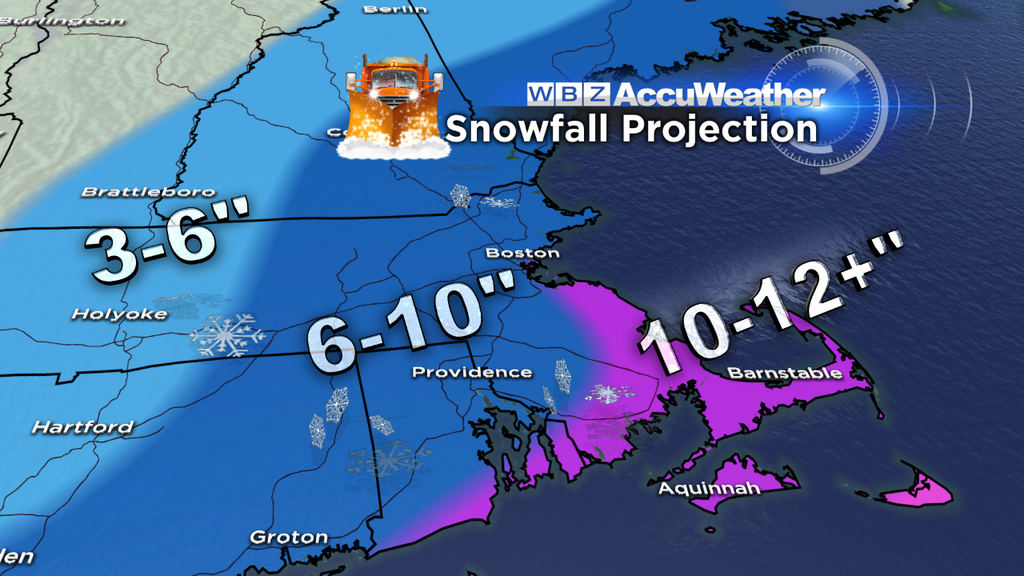
This storm should also feature a pretty sharp back edge - meaning snow totals will drop off quickly to the west. While over a foot isn't out of the question from the South Shore area down toward Taunton and eastward across the Cape & Islands, we're only calling for 3-6" in Western Mass. This may only feature a couple inches for southern Vermont and Central NH. So again in a season of oddities so far, it's the coast that will feature the jackpot of snow more-so than the ski areas and mountains to the north.
Wind and Coastal Flooding Impacts...
As we head into Tuesday night and Wednesday morning, wind gusts will peak across the area. The strongest winds, as is often the case, are expected to be near the coast with this storm. Gusts out of the N/NE at 35-50mph look possible...usually not strong enough for damage or widespread power issues but certainly enough to create biting wind chills and lots of drifting/blowing snow. To have a blizzard, one criteria is to have winds consistently gusting over 35mph for at least 3 consecutive hours (along with visibility < 1/4 mile). This looks very possible.
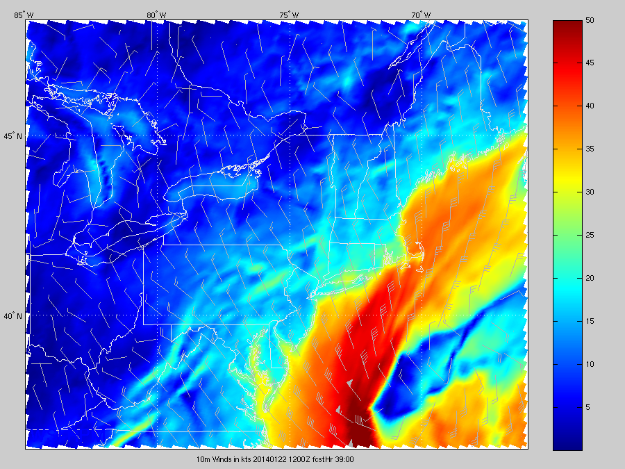
RPM forecast of winds on Wednesday morning. You can see that while breezy, strong wind gusts aren't terribly likely for the interior. But the snow will be blowing all over the place from the North Shore to the Cape. Source: WSI Energycast
In terms of coastal flooding, minor issues are currently all that's expected. Astronomical tides are very low - a 180 from the early month storm where they were near their peak. It's also a storm that should be shorter in duration, helping to keep persistent unidirectional wind at a relative minimum. Some splashover, closures of 'the usual suspects' coastal roads, and freezing spray are the main concerns.
Bitter Cold...Again!
One thing we kept harping on during the early month storm was the unusually cold temperatures while the storm was in progress. This event should follow a pretty similar pattern. Temps will hover in the 10s/20s on Tuesday, and fall into the 0s/10s overnight. The exception to this is the Cape/Islands, where temperatures should hover in the 20s to as 'mild' as 32º. The snow won't be *as* fluffy there, but the water content will lower as we head into the depths of the night. When the storm is at peak by Wednesday morning most of the region will be in the 0s/10s as the frigid air crashes all the way down toward the Cape. The only benefit of temps this cold - all snow! No mixing expected for this one. One less thing to worry about.
When you factor in the wind, wind chill values should fall into the -20 to 0 range. So again, use caution when letting the kids out to play or pets outside to do their thing. This is no joke cold, and will be around for quite a while. In fact, there's a good shot that temperatures for most towns, especially west of Boston, will stay below freezing until February!! Yikes.
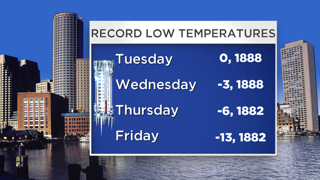
All the record lows this week are over 125 years old! That's somewhat expected, since the official Boston climate site moved from downtown to Logan years ago (easier to be colder away from the water). I think all of these are safe at the moment. This is climatologically the coldest week of the year, and so the records are about as cold as it gets!
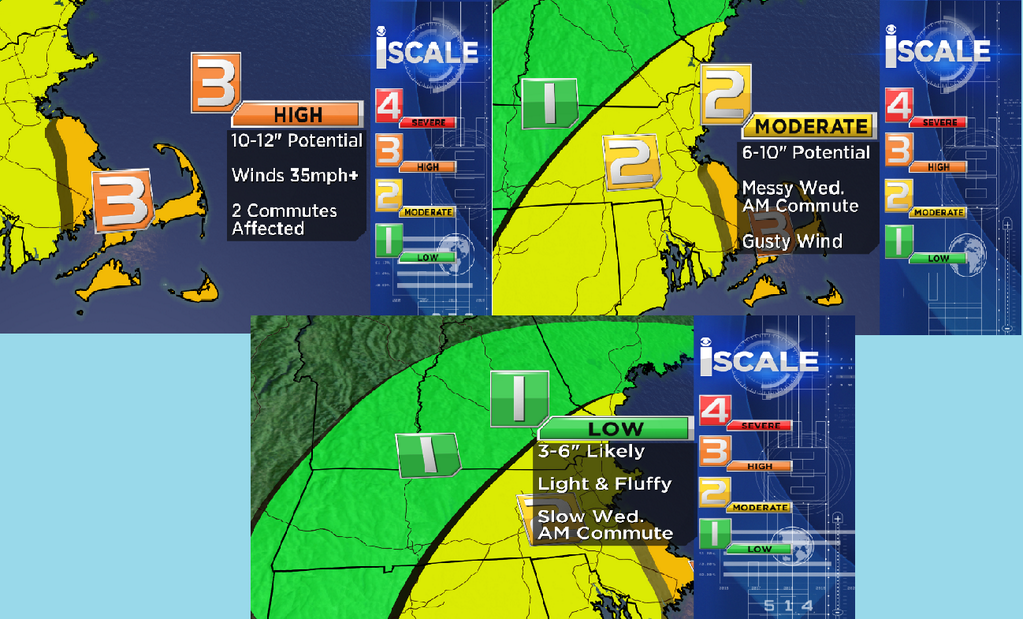
So when you wrap it all up, here is out I Scale for this event. The idea behind the I Scale is to forecast for impact instead of just looking at all the numbers, to help you all plan for storms. This one reaches 'HIGH' impact status in the Blizzard Watch areas, but only 'MODERATE' for many because of the overnight timing of the main push of snow. Impact will be much lower across WMass and nrn New England.
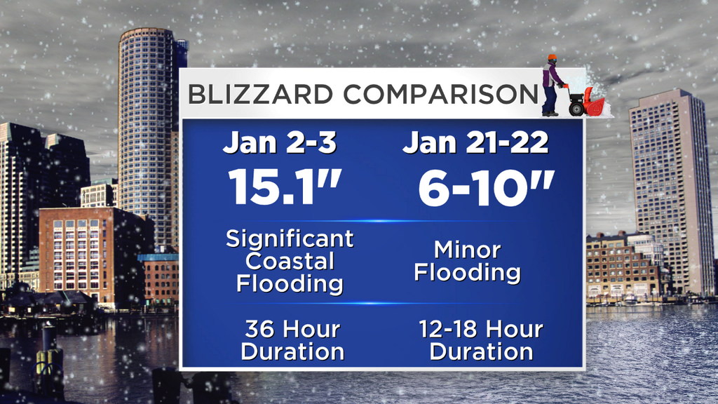
A preliminary comparison between the Jan 2nd/3rd storm and what we're expecting for this one in Boston. Similar in many ways, but calling for just a bit less snow, a shorter duration, and a smaller coastal flood impact this time around.