Mother Nature Rules
When I take my traveling weather show on the road to 1-2 schools per week, one of the topics that I always talk to the students about is the immense complexity of our atmosphere. The more I understand and learn about it everyday, the more amazed I am about the incredible accuracy of weather forecasts from us meteorologists. I think about that more on a day when my forecast has blown up in my face- like today because that's when I remind myself of the many successful forecasts that I have delivered over the past 38 years. I tell the kids that it's like being in school and studying for a test every day that I deliver a forecast. The goal is to get a good grade- an A for an accurate forecast but when the weather doesn't behave as predicted, that doesn't happen and it is upsetting. The atmosphere is super sensitive and a miniscule change in just one of the multitude of variables can make an enormous difference in the outcome. In the end, Mother Nature rules!
Today's surprise stemmed from greater dynamics boosting lift and leading to a spike in precipitation intensity resulting in slightly colder air descending to lower levels so the snow flakes couldn't melt anymore on the way down to the ground. The wet high density flakes were unusually large and they bumped, clumped and clinged together on the way down to the ground. It was quite a sightly thumping of snow with some areas receiving more than 2" in an hour! The forecast verified for the predicted snowfall over areas of interior southeastern NH into southwestern ME and also for no snow projected for southeastern MA and Cape Cod.
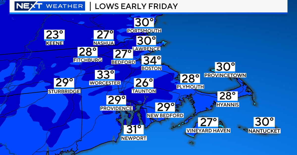
Travelers should be cautious of road conditions this evening and overnight. After a treacherous day of snow-covered or slushy roads with deep puddles in poor drainage locations, the crews have improved the situation but you need to be safe and allow extra time to get to your destination. Be careful on foot as well! Unlike the January 2-3 fluff, this snow is heavyweight and it will set up a bit tonight and tomorrow night then freeze solid when the arctic air arrives Monday night. The low temperatures will reach near or a bit below 30 degrees tonight and a bit lower to the middle 20s or so tomorrow night. Daytime highs both tomorrow and Monday will top out in the middle to upper 30s. The arctic cold front may be accompanied or preceded by some roving snow showers and a couple of isolated snow squalls Monday afternoon. The sequel to the deep freeze starts late Monday night with lows near 10 Tuesday morning. I expect nothing more than 18-22 degrees on Tuesday followed by single numbers to near zero Tuesday night and Wednesday night. Plan on teens for highs on Wednesday and Thursday. Over the next few days, several perturbations in the jet stream will be cranking out clippers racing southeastward from central Canada across the Great Lakes to the Mid-Atlantic region. These will be monitored for any potential development but most signs presently indicate only a couple of spells of flurries or light snow. The first impulse may back the wind into the north-northeast which would trigger ocean-effect snow showers yielding a small accumulation over Cape Cod and southeastern MA on Tuesday. The following clipper could generate heavier fluffy snow across portions of extreme southern New England on Thursday but its progressive motion will limit any amounts.
Looking ahead, the arctic blast will relax its grip on the Northeast next Saturday as a stronger cold front approaches from Canada. Ahead of it, a southwesterly wind will warm the air to the middle 30s before the frontal passage occurs with snow showers that night. Wicked frigid air will rush in next Sunday followed by a reinforcing chunk of even colder air on Monday January 27. That's when Boston could have its first subzero reading since January 24, 2011 when it was -2! Brrrrrr! Single numbers to teens are probable for the high temperatures!
For skiing, snowboarding and snowmobiling, today's snow did not penetrate into the northern resorts. A huge snow storm is needed to open up all of the glades and shoots plus more of the Nordic and snowmobile trails but none is expected in the next week. Nevertheless, you will find deep bases on most of the snow-making slopes with many surfaces as packed powder with some loose granular. Always beware of changing conditions with exposed icy, hard-packed, wind slab patches due to trail traffic and drifting. There will be ideal conditions for snow making as the frigid air arrives. There could be some spotty flurries over the northern mountains tomorrow with some squalls possible on Monday as the cold front presses in. Temperatures will max out in the 20s tomorrow then back to the teens and single numbers as Monday progresses.
Danielle Niles will post her thoughts in the morning and I shall return late in the day tomorrow.
Enjoy the rest of the 3-day holiday weekend.


