On The Eve of Snow...Nor'easter Ahead!
Find Eric Fisher on Twitter and Facebook
Let's kick off tonight's blog with the anatomy of a forecast. I think this is important for a lot of our viewers/readers/listeners to know about. It's meant to be a look behind the reasoning and why we say what we do, when we do. It also addresses some limitations. Plus, you can figure out when to expect certain details!
7-14 days out: Often, NWP (Numerical Weather Prediction) can zero in on patterns and shifts in the jet stream, temperatures, etc. much farther in advance than people realize. If you're a frequent reader here, you know that I'll often point out 'stay tuned' type of scenarios in this time frame. And believe it or not, a lot of these things come true! It truly is a miracle that brilliant mathematicians and physicists have figured out a way to model every particle of our complex atmosphere and make this a possibility!
4-7 days out: We start talking more seriously about potential events. Whether it's a severe outbreak or a snowstorm, the elements are usually coming together at this point. However - anyone who claims to have exact details about what's going to happen is pretty much full of it at this stage, unless they have a direct line to a higher power. While 'possibilities' start to become a lot more clear, the exact details are not in focus yet. Often - the energy driving our weather here in the eastern U.S. is still over the data-poor Pacific Ocean. There's no way to sample the atmosphere here except for ships sending up weather balloons or satellite info. Often the most important and precise tidbits for computer models to ingest don't get added into the mix until the energy gets over North America.
2-4 days out: Now we begin talking about probability of snowfall. You can have a good idea of "chance of 6"+, chance of 12"+" etc in this range. But I can't tell you with high confidence actual snow ranges (maybe at day 2, but not day 3 or 4). There are just way too many factors involved, and too much can change. I find that it's a lot easier to slowly ramp up a storm than to knock it back in the final day or so! The goal in this range is to get everyone thinking about potential impacts and how to plan ahead.
1-2 days out: Finalize totals. Here confidence is typically much higher, and you get a fresh off the presses snowfall map ready for ogling. We throw out our best forecast and hope to the heavens it's correct (or face the wrath of an unhappy public). Give specifics on flooding, snow, wind speeds, temperatures, etc.
During the storm: Nowcast. This is basically tweaking totals an inch or two, same for temps, and giving out current and changing conditions.
After the storm: Have a beer.
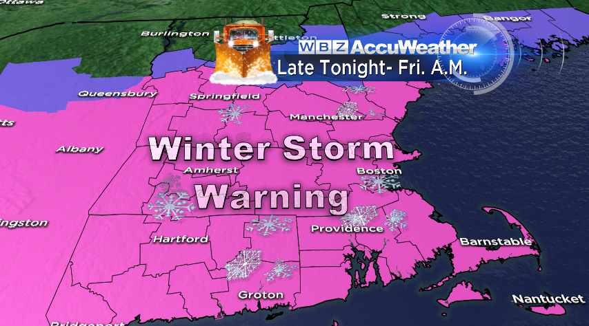
Now...onto the forecast for our first true Nor'easter of the season!
While I don't think this one gets to historic proportions, it's definitely a solid New England snowstorm for many. What's a little different about it is that the highest totals should be closer to the coast (where banding is more likely and cold air will be plentiful) than inland. You're used to seeing Worcester get pounded while Boston and the Cape change over to rain. Not so this time. The whole atmospheric column will be below freezing, which means all snow. One less thing to worry about!
I also think our standards/expectations have changed a bit in recent years. Especially after last year, with two major snowstorms just crushing the area. But in most winters, if I told you Boston was going to a get a foot of snow with winds gusting to 50mph...you'd say that's a heck of a storm! Who knows what the rest of winter will bring. For all we know, this may be the biggest storm of the season for some. But there's still plenty of time to see where those cards lay :-)
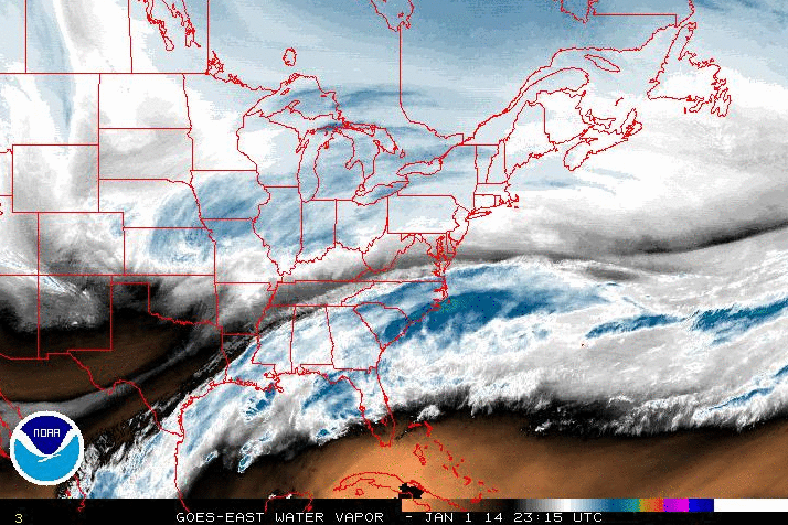
Water Vapor Loop from NOAA. Two pieces of energy (one Midwest one near Gulf) stick out!
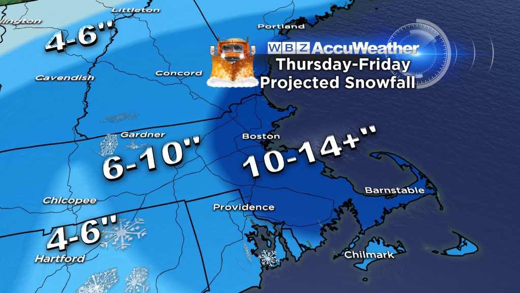
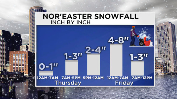
Snow Timeline:
Classic setup for 'this storm is a bust' chatter by tomorrow evening. But be patient! We're watching two pieces of energy, and one is certainly more potent than the other. The first 'arm' of snow is an area of lift stretched out from the Midwest to New England tonight. This will bring light to perhaps even some moderate snow at times, mainly after midnight and through tomorrow morning. We may see an inch or so overnight. Then heading into tomorrow this area will dangle around the region, with areas of light/moderate snow but also quite a few lulls. Needless to say, this is not the main event. We could see 1-3" during the daylight hours, and yes travel will be slower than normal and quite slick. But it's still manageable if you need to commute to work or run some errands. The lull may linger into the evening commute time as well, but check back in tomorrow with us to make sure the coast is clear to head out. You won't want to be caught when things start to pick up!
Thursday night into Friday the coastal low takes control and starts hucking back Atlantic moisture to the west. This deepening low will create a large shield of snowfall from D.C. to New England, with the highest snowfall rates in eastern MA & RI...perhaps down to eastern Long Island too. The majority of our accumulation will occur in this window, roughly from midnight through midday Friday. With a bit of instability during this time, I wouldn't rule out a little thunder-snow mixed in there too.
Friday morning the heaviest snow will mainly be in eastern MA, and quickly it will shut down to the west of I-495. But snow will linger for the South Shore, Cape & Islands until midday, perhaps even into the mid afternoon for the Mid/Outer Cape. It's all gone by Friday evening! Bulls-eye looks to be the South Shore, where ocean enhancement of snow bands could boost a few towns into the 16-20" range if things go just right.
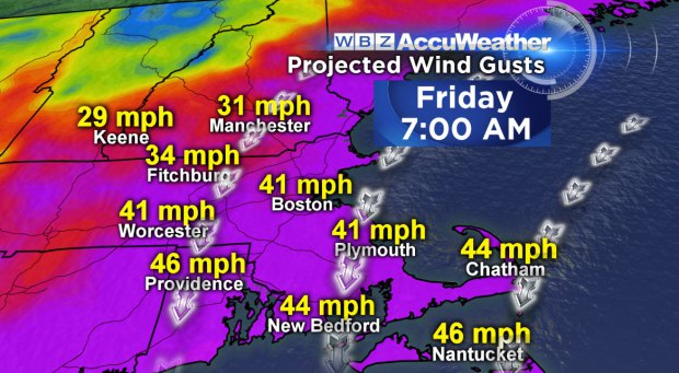
Strong Winds
The strongest winds will blow Thursday night and Friday, gusting to 50mph for coastal communities out of the NE. Combined with a rather fine snow, there will be plenty of drifting and blowing which will cut down visibility. Definitely not a good time for travel. It'll also make a joke out of shoveling/snowblowing, filling the driveway and sidewalk right back in once you clear it. Sct'd power outages may be an issue, but they don't look to be widespread.
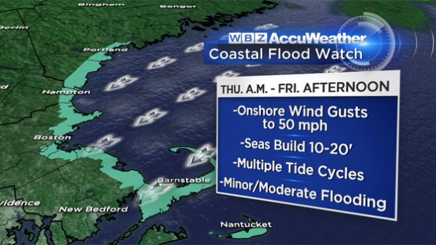
Coastal Flooding
Three high tide cycles to watch, the first near midday on Thursday. This one will feature 'minor' flooding. There may be some mild splashover, but that's about it. The next one around midnight may feature 'moderate' flooding. Local roads right along the shore may need to be shut down due to flooding, with splashover an issue as well. Fortunately, the worst of the storm will be around low tide Friday morning, before the next high tide around midday. That one could still reach 'moderate' flood status because of the long fetch of powerful NE winds over the open ocean, piling the water up along eastern MA shores.
Always a concern with wave action and strong winds - erosion. The potential for significant erosion looks highest from the South Shore to the Canal areas and for the Outer Cape. Fingers crossed that we don't lose much beach (an no homes!) with this one.
School Closings
Already plenty of 'em pouring in! Looks like many districts have figured it's just easier to extend the vacation week instead of going back for one day. While they're probably not necessary on Thursday, they're definitely more deserved on Friday (particularly eastern MA). You can follow all the school closings here.
Dangerous Cold:
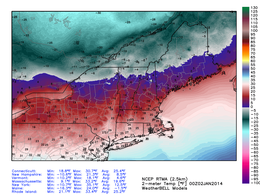
Absolutely frigid air already in place across northern New England and Southern Canada. This plunges southward on Thursday. Courtesy: WeatherBell
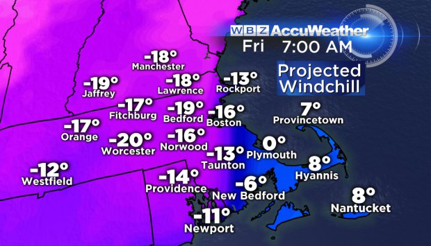
Can't emphasize this one enough. It will be truly bitterly cold for this storm. As winds turn northerly on Thursday we'll see our temperatures drop from the already cold 10s and 20s to the 0s and 10s. Thursday night, much of the interior will be in the single digits with 10s near the coast and 20s for SE Mass. We'll barely warm on Friday, and then fall into record territory Friday night. The record low for Saturday am in Boston is -4, and I think we can break it. Keep in mind it had been 6 years before we broke a single record low (it was done last year, 2013). It's tough to do in urban areas in this day and age. A warming world combined with the urban heat island effect makes it tough to do. So this is truly some rare cold for us. Nearly the entire state should go subzero by Saturday morning. Boston hasn't gone subzero in 3 years (last time was January 24th, 2011).
It's not just the temperature, but the wind chill that's at work here. The combination of strong winds with those cold temps will yield 'feels like' temperatures in the -10 to -25 range. And it will be even colder in northern New England! So in short, this is not a good storm to let the kids play outside for a long time. Make sure that if they do go out, it's with the absolute minimum of exposed skin. Same goes for pets - make sure they do their business and get back inside!
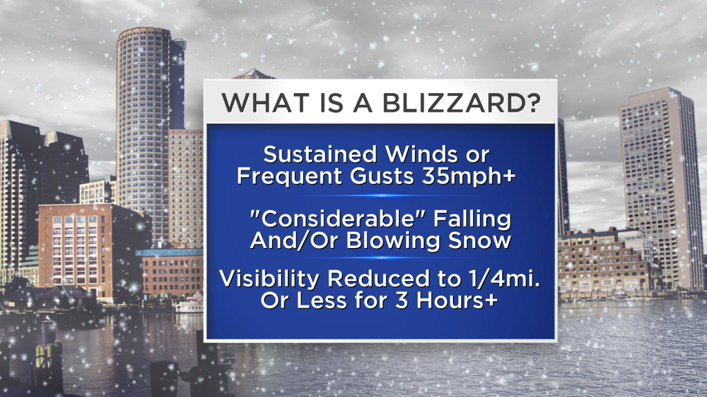
Blizzard conditions can't be ruled out late Thursday night into Friday morning. A blizzard has nothing to do with snow totals, but with a sustained period of strong winds and low visibility. In fact, many blizzards occur across the Plains without any snow falling at all. The bottom line is that there will be plenty of blowing and drifting snow + brutal cold during the brunt of this storm, and it'll be a good time to spend indoors to wait it all out.
And from the 'things you don't want to hear' files - there's another storm on the way for late Sunday into Monday. The ECMWF and GFS camps have been engaged in a game of chicken. Each has not moved from its solution all week long, and each are quite different. From where I sit, I find it hard to believe parts of the ECMWF solution. So what I'm calling for at the moment is a storm that will move through quickly and bring some wintry mix, but mainly rain. The ECMWF torches us into the upper 50s on Sunday evening, which seems pretty hard to do with over a foot of snow on the ground in January with just a 24 hour window of southerly winds. I'd lead more toward a forecast of potential icing to start, then a changeover to rain before departing. We'll have more time to take a closer look at this in the coming days. But either way, it will leave a mess in its wake. Rain and ice, on top of snow, with a MAJOR cold blast immediately following. Can you say cement? Temperatures will be downright brutal next week as a piece of the polar vortex breaks off and plows in the Lower 48. And we won't be alone. Most of the country will be looking at record-breaking cold, as we see it right now!
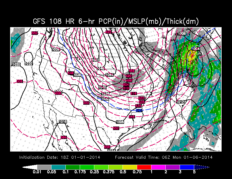
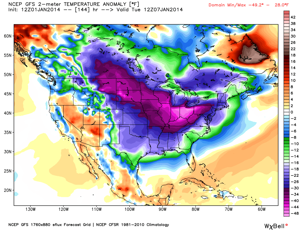
Combo of a storm Sun/Mon and a blast of WAY below average air. Will make a total mess of things. Courtesy: WSI and WeatherBell


