Much To Watch
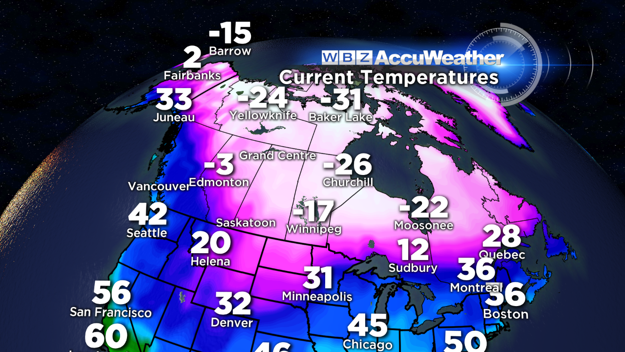 The evolving weather pattern is going to keep us on the edge of our seats for at least the next week. The cast of characters is growing larger and the plot may thicken at any time. The presence of arctic air building in Canada way back in late October and November caught my eye and we subsequently have seen several attacks of harsh winter temperatures into the nation. International Falls, MN has endured one of its coldest Decembers ever on record. The number of national record low temperatures never makes it into the news like the record high temperatures perhaps for fear that it would squelch the global warming alarmists. The reality is that weather is very cyclical over weeks, months, years, decades and centuries. Our planet has experienced ice ages and meltdowns dating back thousands of years. There is always two sides to every story and we can't dismiss the possibility that global cooling is more of a threat. Nobody really knows for sure what the long-term holds for all of us. Shorter range forecasting from seasonal to daily is much more accurate and I can assure you that some very cold air is coming as we commence the year of 2014. The magnitude of the cold is not etched in stone but realizing that super subzero air will exist across much of Canada over the next several weeks, we must be vigilant as any slight directional wind change could escort brutal record-breaking chill into our country especially the northern states. It appears that the ocean temperature distribution in the Pacific is one of the key players in driving frigid air from Siberia across Canada. A pool of much warmer than usual water in the Gulf of Alaska may indeed be linked to this phenomenon. So while El Nino and La Nina are nonexistent again this year like last, there are other factors that will make this winter different. Hence our winter forecast of near to below average temperatures compared to NOAA's warmer than average winter prediction still stands. Last December's mean temperature was 3.7 degrees above the average while this December will end up being close to 2 degrees below the average. November was also -2 degrees and that, in my opinion, is a relatively decent clue how at least the first half of the winter will be. Two years ago when the entire fall was much much warmer than average, we knew that the winter would be easy and uneventful and we, gladly, all saved a lot of money on heating bills.
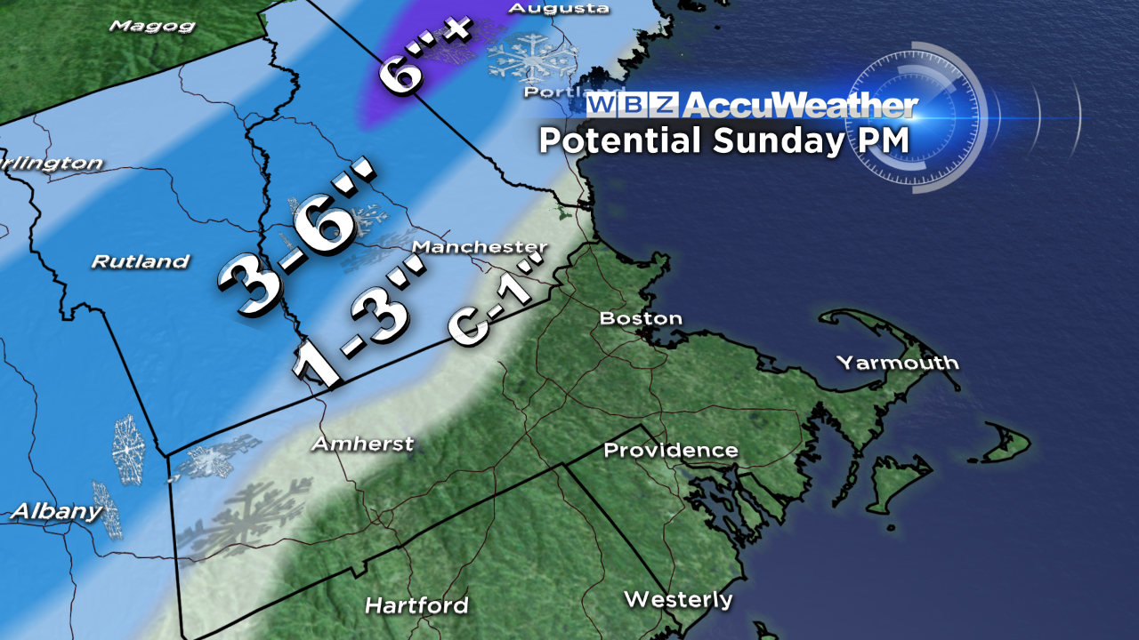 Oh well, I apologize for going OT so let me get back to the short-range forecast. As has been advertised for 2-3 days now, a soaker is guaranteed for tomorrow afternoon and evening. The developing wave of low pressure is emerging from the Gulf of Mexico so it has tapped a rich moisture supply leading to a blossoming envelope of rain tracking northeastward. Its e.t.a. is early afternoon with the temp ramping up from moderate to heavy rain from about 5 to 10 pm. This is coincident with the Patriots/Bills contest at Gillette Stadium. Wear 100% water proof clothing because it is going to be very wet with temperatures near 40 and a moderate breeze at times but no strong winds are foreseen for that area. A HIGH WIND WATCH has been posted for Cape Cod for tomorrow evening as gusty southeast to southerly winds may spike to 25-50 mph as the warm sector streams up over that region. On the flip side, dynamic/evaporational cooling will lead to any cold rain transitioning into wet snow over northern New England and that snow line could collapse as far south as northern MA for a brief spell late tomorrow evening but I would expect nothing more than a coating up to an inch max there. It is more likely that farther north into southern NH and southern VT, there will be a buildup of 1 up to 3" with 3-6" projected from central VT across central NH into much of ME. There could be pockets of more than 6" in favorable locations mainly in central ME. So that is good news for the ski resorts but they really need a bonified blizzard to open up all the terrain. Tomorrow's temperatures will rise from the lower 30s to the upper 30s north and west of Boston to just over 40 around the city along the MA Pike to the lower to middle 40s over southeastern MA to 50 on Cape Cod later in the day.
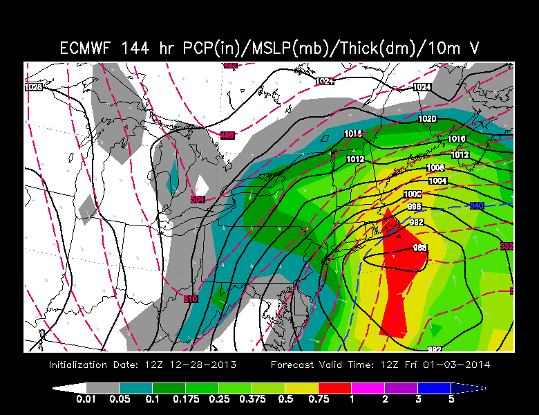 In the wake of the storm, a cold front will cross the region on Monday with the passage around midday in the Boston area. Temperatures will top out in the upper 30s at that time then decline a few degrees as the afternoon progresses via a brisk westerly wind under a partly sunny sky. A weak trough of low pressure will arrive Tuesday afternoon with some scattered snow showers which may last into New Year's Eve. Daytime highs in the lower to middle 20s will drop back to 20 to the teens for First Night activities with an average temperature near 15 degrees as we ring in 2014. There will be a cold breeze but not a harsh wind during the evening. A piece of the arctic air will invade the area on Wednesday through Friday. Expect highs in the upper teens to 20 or so. There is a degree of uncertainty regarding potential snow for later Thursday and Friday. As a bubble of high pressure builds to the north, an amplifying trough of low pressure in the Ohio Valley is poised to produce a developing storm toward the Mid-Atlantic States. Presently, it is indeterminate how potent this feature could become. On my blog last evening, I was not buying into that solution but now there is more substantial evidence that snowy weather will develop into at least southern New England. The usually more reliable guidance is now depicting a major n'oreaster with very strong winds and possible fluffy snowfalls of 1-2 feet except on Cape Cod! I cannot pull out the stops yet because it is too premature. The strength and path of this system will be determined by the amplitude of the eventual upper level trough and that cannot be accurately determined at this early stage. It will be interesting to watch how this scenario zigs and zags in the days ahead.
Danielle Niles will deliver her thoughts tomorrow morning and I shall follow later in the day.
Enjoy the final Sunday of 2013!