4Casting The Rest Of 2013!
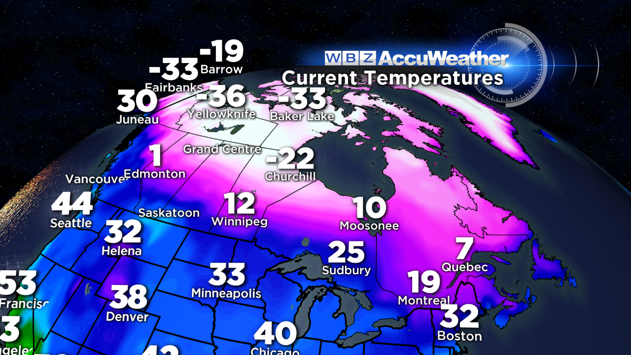 In sharp contrast to the past two Decembers which had mean temperatures at 5.3 degrees above the average in 2011 and 3.7 degrees above the average in 2012, this December will be close to 2 degrees below the average which is similar to 2010. With a reservoir of super frigid air across much of Canada, it appears that we are in for some arctic outbreaks unless the upper air steering currents pattern shifts abruptly. Overall, I am expecting colder than average weather in January and February as well based upon a number of existing factors and correlating analog years. There will be some fluctuations with some brief warmups but most signs indicate a colder winter than last year for sure. As the brutally cold air expands from western to eastern Canada, we must be vigilant to attacks from the north. One such invasion of numbing cold is timed for the beginning of 2014. As the polar vortex migrates southeastward into northern Quebec in response to blocking evolving north of the Arctic Circle, we will be in a precarious place for some of this arctic chill to plunge into the Northeast. Present indications point to this happening the first 3 days of the new year. I am anticipating the coldest air to occur on Wednesday night and Thursday. Some subzero temperatures cannot be ruled out all the way down into northern MA with daytime highs struggling to exceed 10-12 degrees above zero on January 2nd! Heating demand will sharply spike and we will be paying more to keep our homes warm. Fortunately, persistent relentless subzero cold is not coming just bursts of bone-chilling air.
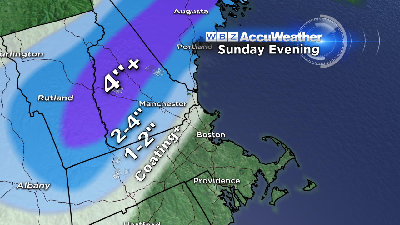 Before that happens, we will enjoy much milder air tomorrow with temperatures approaching the middle 40s amidst a changeable sky of clouds and sunshine. Meantime, a lobe of moisture in the western Gulf of Mexico will be captured by a short wave in the southern stream and transported up the eastern seaboard. The disturbance will trigger storm development over GA and gradual intensification is anticipated on its journey to Nova Scotia. The center will pass over the Cape Cod Canal late Sunday evening on its way to the Canadian Maritimes. The system is destined to generate over an inch of rain starting early Sunday afternoon and terminating near or just after midnight Sunday night. The heaviest rain is anticipated from near 6pm to near 11pm so it will be soaking wet at Gillette Stadium as the Patriots host the Bills. The east-southeasterly wind will be blowing at 10-20 mph with a temperature in the lower 40s to near 40 as the day progresses. As marginally cold air gets additional dynamic cooling, a switch to wet snow is probable across southern portions of VT, NH and ME. The precipitation will likely start as snow north of that axis. The odds favor a collapse of the snow line down into northern MA later in the storm cycle so the duration of snow will be shorter and no more than a coating to an inch of sloppy snow is projected across northern MA building up to 1-2" over northwestern Worcester County extending into southern NH and southern VT with amounts building up to more than 4" in s strip from central VT across the Lakes Region of NH into central ME. The far northern mountains are in line for 4" or less of snow.
A cold front will cross the region on Monday with passage predicted close to midday in the Boston area. As a result, Monday will still be relatively mild compared to the rest of the week. Expect highs in the upper 30s at midday with colder weather later in the afternoon. A drop to the teens is likely Monday night followed by highs in the lower 20s on the last day of 2013. A couple of perturbations in the upper air flow will create lots of clouds Tuesday afternoon through much of Wednesday. There could be some scattered snow showers through that period so you might see some flakes on First Night and on New Year's Day but no accumulating snow is foreseen at this time. I expect temperatures falling back into the upper teens early Tuesday evening to the middle teens as we ring in 2014. Midday highs on January 1st will be in the lower 20s. After that, the coldest air digs in over the Northeast supporting the aforementioned brutal cold late Wednesday night and Thursday. Less harsh conditions are in store for later Friday and next Saturday but it will still be much below average. One caveat is that there is some model guidance that is depicting a major storm over the Northeast late next Thursday and Friday. Presently, I do not feel comfortable with that solution because I do not buy the amplification of a deep trough farther west which would steer any storm into New England. Instead, an upper air pattern favoring storm development farther offshore and a resultant drive of frigid air into the region from Canada is more reasonable in my opinion.
For skiers and riders, all resorts need a major snowfall to open up all of the terrain especially the glades and non-snowmaking trails. The slopes are machine-groomed and ready for your skis and boards but open terrain is limited from place to place due to the lack of significant snowfalls. As the air turns cold to frigid, snow-making equipment will be pumped to the max. Temperatures this weekend will be in the 20s and 30s by day from north to south with the frigid air arriving late Monday. Unfortunately, the late Sunday storm will not produce a blitz of snow but we will take every inch we can get on the slopes. Be safe and in control on the mountains and THINK SNOW!
Danielle Niles will post her thought in the morning and I shall follow later in the day.
Have a great weekend.