Cold Returns for Christmas...It's a Festivus Miracle!
Find Eric Fisher on Twitter and Facebook
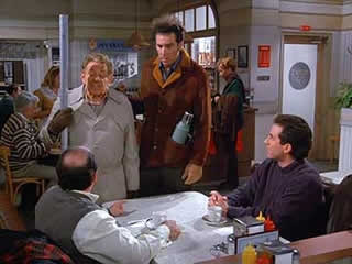
Courtesy: Seinfeld, 1997
"As I rained blows down upon him, I thought - 'There has to be a better way.'" - Frank Costanza.
A Happy Festivus to all! It would not be complete without the airing of weather grievances this evening. Since weather affects everyone and is ongoing every day, most have formed some strong opinions about it. So without further ado - the grievances for 2013.
- Bad 'You get paid for being wrong' jokes. Come on...if you're going to hate on the weatherman, at least be original!
- Seeing every storm get labelled 'worst ever' or 'extreme.' Sometimes...it's just a storm.
- The use of 'normal' instead of 'average.' Normal is philosophical when it comes to weather!
- Climate change being applied to every single thing that happens
- Related note - people who bring up Al Gore every time there's a cold day or snowstorm
- The use of 'skeptic' as a negative thing. Being skeptical isn't just a good for science, it's necessary.
Feel free to add to the list below! Try to keep it clean though :-)
Rain Ending, But Becoming Icy Tonight....
Now onward to more pressing matters, ie. the forecast. Fortunately, temperatures have warmed just enough across MA and most of southern NH to keep us out of a freezing rain scenario tonight. Garden variety rain showers will continue through about 10pm in the Greater Boston area, but will be stubborn to move out for SE Mass. In particular, the Outer Cape & Nantucket, where showers may linger all the way into late morning tomorrow. Clouds will also cover most of the Cape & Islands for the first half of Tuesday.
Even though it's not freezing rain, icy travel will become a concern tonight. Drier and colder air is on the way in, and temperatures should settle back into the 20s by daybreak tomorrow. Most of the subfreezing air will wait until after midnight. But if you're out late shopping or need to travel for other reasons through tomorrow morning - be warned that it could be very slick on untreated surfaces. It's not a 'flash-freeze' type of setup where temperatures crash and everyone freezes up at once. More of a gradual settling down below 32º. Most of us have small ponds gathered in our yards due to the rain and snowmelt of the past few days, and many of those will start to look like ice rinks by the time the sun comes up.
While the front heads offshore tomorrow, another trailing impulse will move in during the afternoon and evening. This will keep us from full sunshine, and more of a partly sunny sky instead. With 850mb temps crashing down into the -14C range by the evening, temperatures where we all live on the surface will barely budge all day long. Upper 20s to mid 30s are as far as we get. Even though some towns won't get above freezing, morning ice should still melt away in most spots due to solar radiation doing it's thing.
Ice Storm Up North...
There are still tens of thousands of people without power in Vermont, New York, New Hampshire, and Maine - and many more in Michigan from this weekends' (lingering into today) ice storm. This is not only a major inconvenience right before Christmas; it has also turned deadly. One man has been killed in Albany, VT due to carbon monoxide poisoning. He was running a generator inside his home. (Read story here) You should NEVER operate a generator or grill inside a home, but sadly this sort of thing happens all the time during prolonged power outages. This is a good time to check on friends and neighbors to make sure they're not trying to tough out brutal cold or doing something that could prove deadly. Many customers will likely be without power for at least another 24 hours, if not 48-72 hours. Widespread ice totals of .5"-1.5" were seen, and with very cold air moving in there won't be much melting in the days ahead.
Christmas Eve Snow?
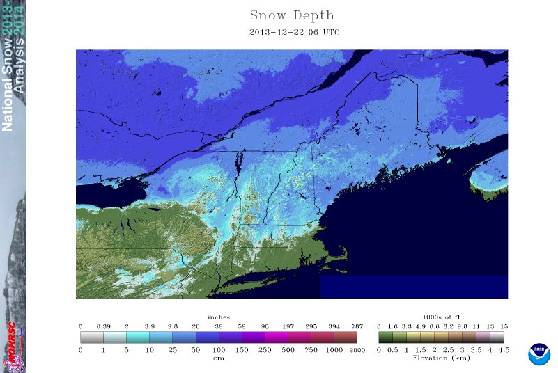
The Northeast snow pack took a beating worse than the Ravens this weekend. The region lost 33% of its snow cover. Courtesy: NOHRSC
So you're saying there's a chance! I read you. Classic movie quote, and applies to our Christmas Eve snow chances. That wave of low pressure tracking through will bring clouds and perhaps just a few snow showers to the region in the evening. After losing pretty much all of our snow over the past 3 days, this may bring a smile to quite a few faces! If it develops, it should be low impact on the roads. More festive than anything else. Fingers crossed. As we move deeper into the night and St. Nick starts his trip the real cold sets in, and most towns will be in the low 10s by dawn Christmas morning.
Hopefully you get a nice new Cosby style Christmas sweater this year, because you'll need it on Wednesday. Temperatures will stay in the 20s across the board, a good 10º below average. In case you're wondering, the coldest Christmas in Boston on record is -8º. Some more Christmas 'extremes' are below. No new records in 2013, just a very chilly holiday. The good news is that with high pressure overhead there shouldn't be an excess of wind to deal with, and skies will be bright.
Rest of the Week/Weekend...
Not much happening in the medium-range. A weak system will bring cloudiness and a few rain/snow showers on Thursday. At this point, it doesn't look like it will have much impact. Chilly but seasonable weather on Friday, and more of the same on Saturday. By late Saturday and into Sunday a broad southwesterly flow will take over ahead of the next weather system. This will help warm us up, and by Sunday afternoon we may be able to reach the upper 40s again! Would be pretty sweet for the huge Patriots game at Gillette as they try to secure a bye and home field advantage throughout the playoffs. But that warmth won't last for too long. An arctic front is poised for Monday, and behind it comes a blast of truly cold air.
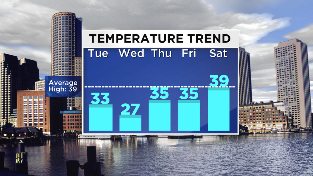
This is the first day of the season when the average high in Boston drops into the 30s - and we'll be below that mark all week!
Early Peek at New Year's Eve...
Speaking of that cold, it arrives just in time for NYE! Lucky us. Cocktail dresses may be tough to work with as some brutally cold air may be able to spill down into the Northeast to ring in the new year. Most models are on board with this and show a pretty strong signal that the start of 2014 will be off to a very cold note. The NAO is also showing signs of going negative, which means our snowstorm potential may increase too. In any case, we won't be starting January with a thaw.
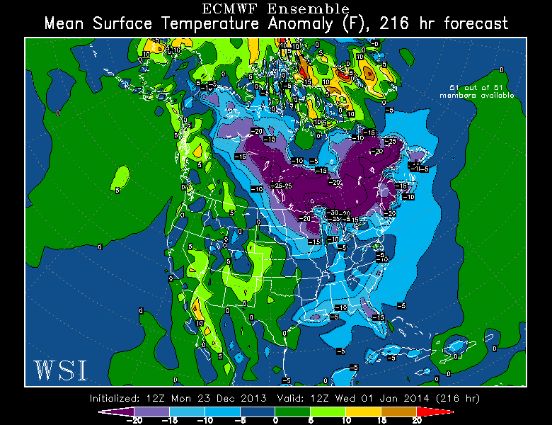
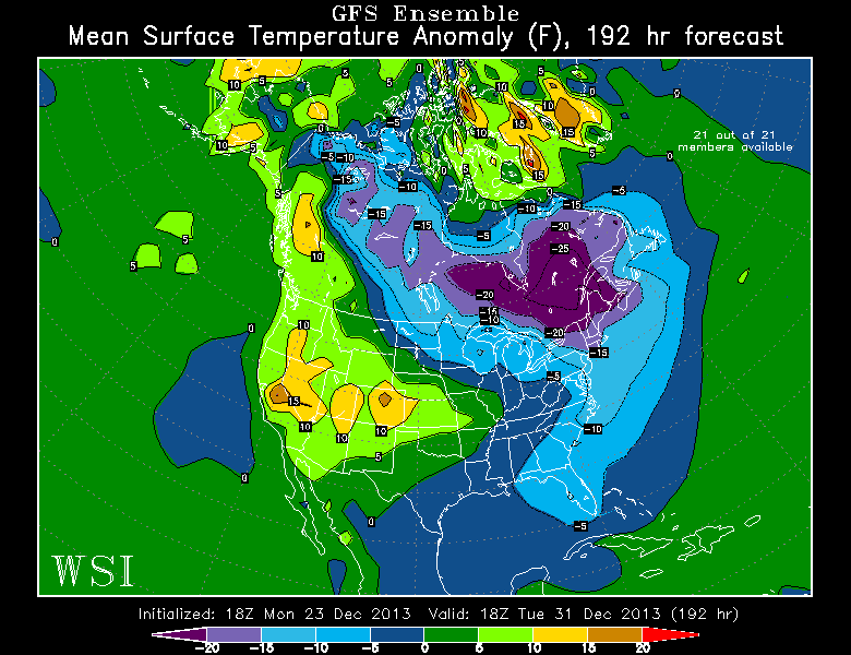
ECMWF and GFS Ensemble forecasts for January 1st. Polar vortex shifting south, very cold air potential from the Upper Midwest to Northeast. Courtesy: WSI Energycast