60s to 30s - Location Is Key on Sunday
Find Eric Fisher on Twitter and Facebook
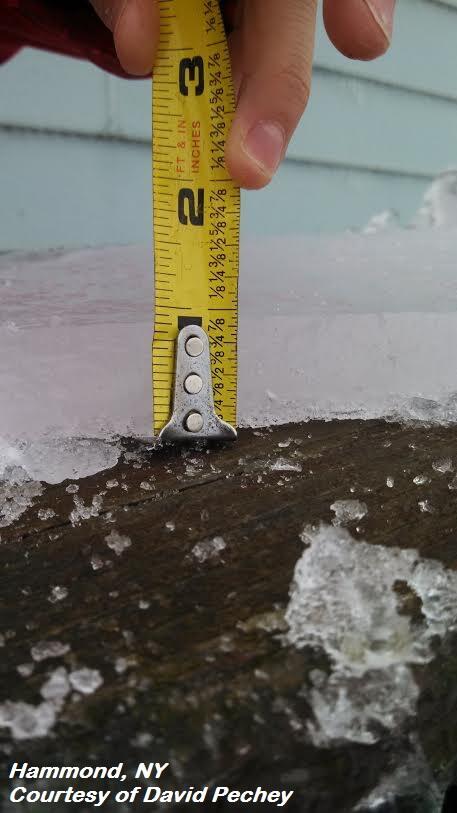
A sign of things to come to the north...ice accumulation in Hammond, NY on Saturday.
First day of winter? Not quite. Many towns made a run at 60 today as we kicked off winter with the solstice at 12:11pm EST. But I have to say, I've never seen so many happy people walking around town. Big smiles soaking in the break from a very cold stretch and taking care of some last minute holiday shopping. If I'm doing the math right, today was the 1st scheduled long run for anyone doing an 18-week Boston Marathon training program. But tomorrow, it won't be so easy.
Extremely Warm....BUT…
Talk about a headache-inducing forecast for Sunday into Monday. The same boundary that's been draped through New England and meandering a few miles here and there will start to quicken its pace a bit heading into tomorrow, and that makes for a very complex forecast for us. As mentioned last night on the blog...the main areas of concern are Middlesex & Essex Counties, NE Worcester County, and southern New Hampshire.
In essence, an area of high pressure to the north will help buckle that quasi-stationary front down the Maine coast and into NE Massachusetts. Northeasterly winds will push temperatures down from the 50s to the 30s, and in the case of southern New Hampshire perhaps even into the 20s for a couple of towns. So you can see the dilemma here. While some bask in the 60s in Massachusetts, 50 miles up the road freezing rain will be a possibility.
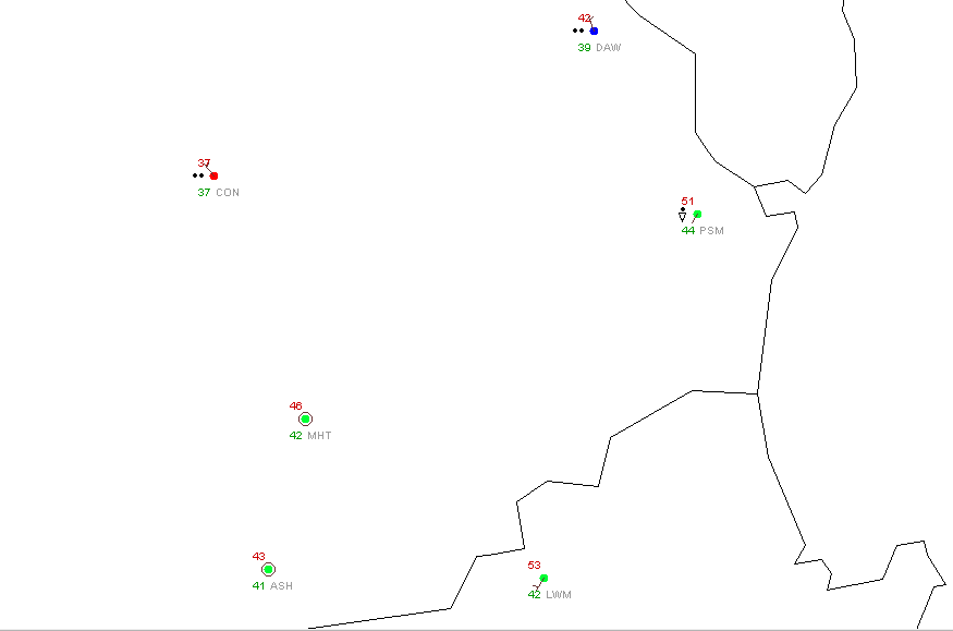
We are already seeing evidence of that tight temperature gradient this evening. A look at the 6pm observations show low 50s in Lawrence but 30s in Concord! Depending on which side of the line you end up on, you may have very different opinions about Sunday's weather. Some models are more aggressive with this cold push, like the RPM (Rapid Precision Model). They bring a blast of cold southward by late morning all the way down into Metro Boston and to the eastern half of the Pike. I think this may be a little overdone, but it's not out of the question.
The Main 5 Points for Sunday...
- Dramatically colder air looks likely for Essex & most of Middlesex Counties on Sunday. While 30s are expected, I think we'll stay just mild enough to keep freezing rain at bay (just typical rain showers instead).
- Southern New Hampshire looks cold, particularly the eastern side of the Monadnock Region. Keene and Jaffrey may avoid the 30s. In this cold air, there may be some freezing rain concerns. Travel with are and keep a close eye on temperatures.
- Cold air will most certainly be in place across southwest Maine, so expect very ice travel northward on I-95 and across nearly all of the state.
- South of the Pike, all towns should stay in the 50s to low 60s with extremely mild air in place
- Boston is on the border right now. I think the North Shore may get into the cold, but downtown Boston may just barely stay on the mild (50s) side of the boundary.
Rain Potential…
Most of the steady wet and icy weather will avoid southern New England this weekend, but the best shot of rain comes tonight as the boundary droops southward. Highest chance for significant rain will be northern MA and southern VT/NH. Lesser totals are expected south of that line (<.30" through Sunday). Poor drainage flooding will again need to be watched due to the combo of snow melt and additional rainfall, and perhaps even some ice jams developing on a few rivers.
Snow-eatin' Fog…
When you bring dew points in the 50s on a southerly flow over snow, you get fog. And it should end up being as thick as peanut butter (courtesy: Yukon Cornelius) in some areas Saturday night into Sunday. So snow will continue to melt pretty quickly, even at night. Driving may become dangerous too with visibilities lowering to less than 1/4 mile.
The combo of warm temperatures and fog will do a number on the snow we have left. What's still on the ground for Christmas morning? I'm thinking that south of the Pike you'll be hard pressed to find any snow outside of piles in parking lots by Wednesday (hills of RI and CT may hold onto some of theirs). There should still be some snow on the ground north of that line, but downtown Boston may be an exception as warmer air may do away with the vast majority of snow there. Around northern MA, I'll be surprised if all the snow is gone by the time Santa visits.
Monday Travel….
Not looking like much more fun on Monday, as a wave of low pressure rides up along the barely moving front and spreads rain back over eastern New England. I think that cold air won't be cold enough for snow or ice in Massachusetts with this one, which at least takes care of one problem. But again with the threat of steadier, heavier rain and a lot of melting snow, there could be quite a few spots of poor drainage flooding and water filling up all the low spots. That may cause issues for Monday PM travel.
And hey, there's a *chance* we could see some snow before Christmas. As cold air moves in behind the front, it may match up just in time to change rain over to snow Monday night into early Tuesday morning. Most of the precip should be in far eastern MA at that point, so we'll keep our fingers crossed for our friends on Cape Cod & The Islands.
Christmas Eve and Christmas Day…
That pesky front should finally move completely offshore by midday Tuesday with Arctic air draining in behind it. Whatever we're at on Tuesday morning will be our high for the day, likely in the low 30s. A gusty wind will make it feel much colder, and it will be a downright cold Christmas Eve. Good weather for putting an extra log on the fireplace! Wind chill values may dip into the single digits by late evening.
High pressure crests overhead on Sunday, so lighter winds and plenty of sunshine for Christmas Day itself. Not travel issues anywhere nearby, and most of the country looks pretty peaceful. But will be quite cold – as of now it looks like most of our area will stay in the 20s.
Major Ice Storm up North...
While all of this is happening, a major ice storm will be unfolding to our north. Anyone with friends, property, or plans in that direction should be prepared for what could be widespread tree damage and power outages. This mess has already started, with snow, sleet, and freezing rain falling since early Friday. The intensity of that icing will pick up tonight and into Sunday.
The issue at hand is that very, very mild air will be flowing up through the low & mid-levels. So in the clouds, it'll be rain that's falling. But at the surface, high pressure in Canada will direct cold air across the surface, keeping temperatures below freezing. So as the rain falls it supercools and freezes on contact.

Note the surge of warm air at 850mb (few thousand feet up). With temps this warm, snow is impossible. Only spot for big snow this weekend is expected to be northern Maine. Courtesy: WeatherBell
Now forecasting a major freezing rain storm is very difficult, because the criteria is so strict. Conditions must be just right to see significant ice accumulation. We're talking temperature, topography, timing, etc. A little too much cold air near the surface and you've got a sleet storm. A little too much mild air works in and you change to rain. Some colder air funnels in a few thousand feet up and you change to snow. So the confidence is not enormous.
But over 1″ of precipitation will fall, one way or the other. If much of that is freezing rain, it will be very destructive. 1/2″ of ice accumulation adds 500lbs to power lines. Power crews have already put out mutual assistance calls and NSTAR has sent crews north to help with potential outages. The areas most at risk look to be around the Champlain Valley (Burlington area), northeastern NH, and much of central and coastal Maine. And the main timeframe to watch is Saturday afternoon through Sunday afternoon.

GFS model sounding in Burlington Saturday night. Note the subfreezing air at the surface, but above freezing air farther up in the atmosphere. Courtesy: Wright-Weather
Very specific elevation slices will be impacted. Valleys in amongst the mountains run the highest risk, because cold air can stay trapped by warmer air aloft. The higher mountain peaks will actually be much warmer and likely turn to rain. On Mt. Washington, they'll threaten record highs! Some of this icing may work as far south as southern NH/ME on Sunday.
So bottom line is to prepare for possible long-term power outages and to make sure you're ready to get through some tough days. If it doesn't pan out and we get more sleet or rain than anything else, than great. But it never hurts to get ready for the worst.