Tracking Our Weekend Storm
Arctic air has moved into the region making for a cold start this Saturday morning. There's no question as to what type of precipitation we'll all start as later on today…SNOW!
WINTER STORM: Current Conditions | Interactive Radar | Weather Blog | Share Weather Photos | iScale | Closings
Timing: Snow showers will develop and come in off the ocean in eastern MA from late morning into the afternoon…but this is not the main event. Nonetheless, a few coatings will develop in some of these bursts of light snow from Cape Ann to the South Shore and Cape Cod. Steadier snow will fill in from west to east between 4-8 PM, ramping up from there and falling heavily at times overnight. There will be a rain/snow line to track with this storm. The Cape/Islands will changeover first and that transition will creep northward through the South Shore and perhaps as far north as the MA Turnpike and North Shore by Sunday morning. The intensity and coverage of the wintry mix will taper by midday, though a lingering snow shower is possible in the afternoon, mainly north of Boston.
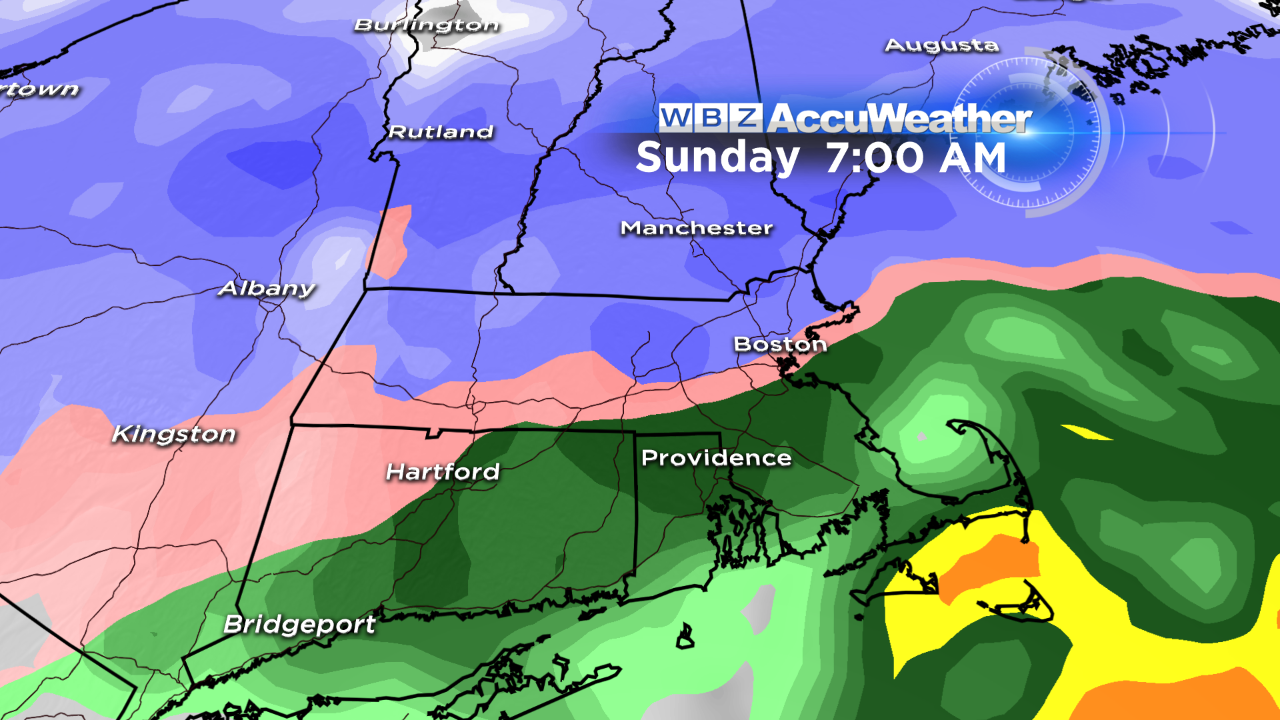
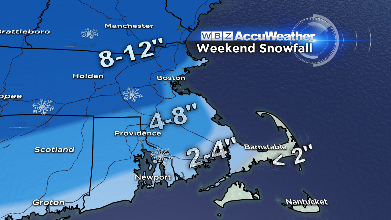
Accumulations: As the accumulation map shows, the highest amounts will be focused just outside of Boston stretching into central MA and southern NH. The lowest amounts will be on the Outer Cape and Islands. Expect a fluffy consistency to the snow inland, with a slightly "wetter" snow as you head towards the coastline. There will be a coastal front that sets up just northwest of the rain/snow line - where snowfall may be enhanced, so we'll watch this closely.
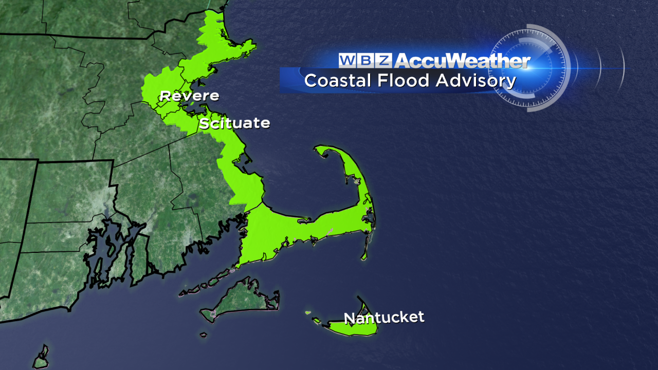
Coastal Concerns: With an onshore wind developing and strengthening tonight into tomorrow morning, the seas will build and minor pockets of coastal flooding will be possible 2 hours either side of the 10 AM high tide cycle Sunday morning. A few locations to monitor: Revere, Boston Harbor (Morrissey Blvd), Scituate, Nantucket (Easy St.) East wind gusts may reach 45 mph on the outer Cape and Islands where a wind advisory is in effect from 11 pm tonight until 7 am Sunday.
Looking ahead, a clipper system will slide through Tuesday with a period of light snow, which may accumulate a few inches in some communities. We'll take it one storm at a time!
If you're out and about enjoying the snow tomorrow – snap a picture and send it to us: weather@wbz.com. We'll do our best to get as many photos as we can on-air!
-Danielle