First Significant Snow Heading In!
Find Eric Fisher on Twitter and Facebook
First off, an editorial. This is in now way to call out anyone who does this in practice, because it's all subjective and maybe in the end is the right way to go. But a question for the readers - Do you like it when a Meteorologist shows you 4 different model totals stacking across the area, then shows you the actual forecast? I was watching this at the gym today and saw everyone looking up with confused faces. The models are a significant part of how we forecast these days. We're always watching minor trends, changes in variables, consistency, etc. But in my mind, a lot of that information is for us weather geeks. The average viewer probably doesn't give $.02 what the ECMWF is, or what it's saying. They're just asking 'What's going to happen?' For that, all you need is the forecast. Here are the totals: BOOM. Done. Showing 5 different versions of what's going to happen just muddies the water. It's interesting TV for sure, but I wonder if it helps get the most accurate and easy to understand information across. On the flip side, maybe it's just the future of how we display weather information. Food for thought! I'd be curious to hear your thoughts in the name of research.
I digress...here are the details on our incoming significant snow!
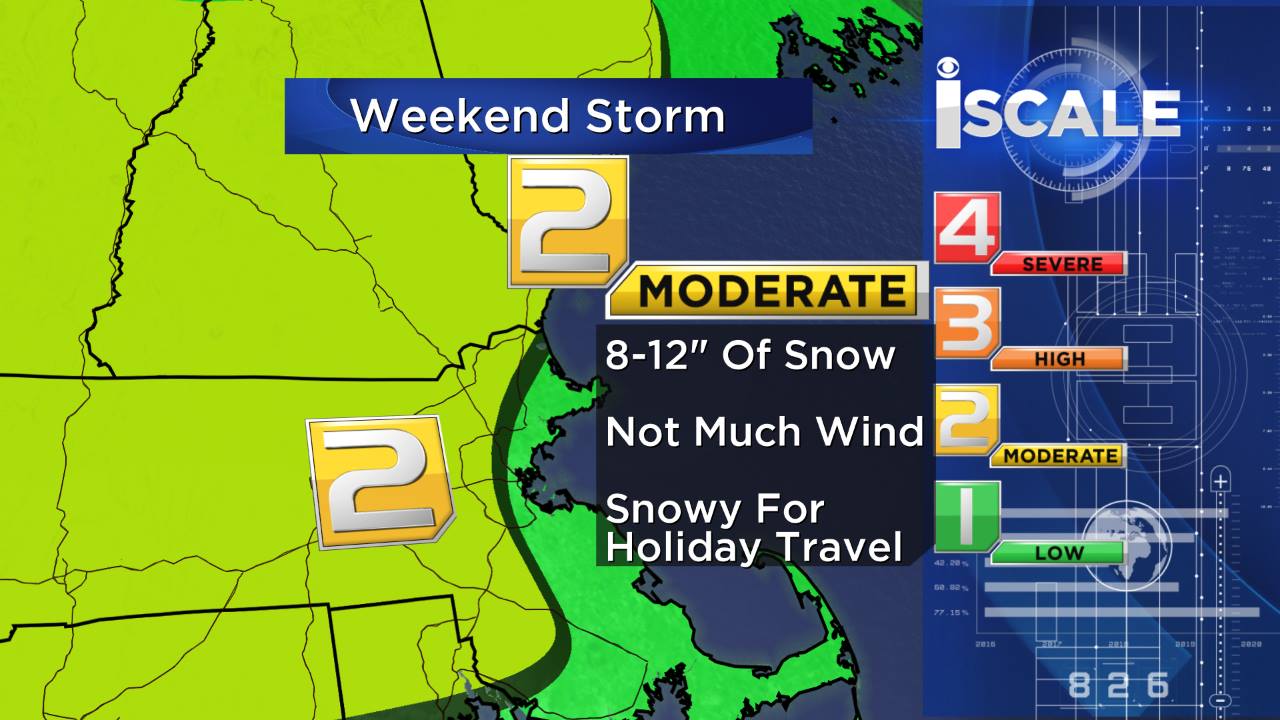
Read all about the I Scale and how it works here: WBZ I Scale
The Setup...
To kick things off, a heaping of cold air well entrenched. Some of you saw a smattering of snow squalls today. Well that was the leading edge of a cold front, ushering in yet another reinforcing shot of cold air from the north. It'll help drop our temperatures into the 0s and 10s tonight, and stay in the 10s/20s tomorrow. This keeps a long streak of very cold air going (Worcester hasn't been above freezing since 8am Tuesday). That long stretch of 10-20º below average air has helped freeze up the ground, and cool down surfaces. So when the flakes start to fly, there won't be any melting going on. It'll stick as soon as it falls on Saturday.
That cold air is also dry air, and this will play into the snow 'type' during the storm. For most of the interior, it'll be pure fluff. Nice light snow that will stack up and near a foot in many towns before it all departs. That won't be the case the whole time near the coast or into SE Mass, but away from the water's influence the Arctic air mass will keep this an easy-to-shovel snow, and because of that power outages are not expected.
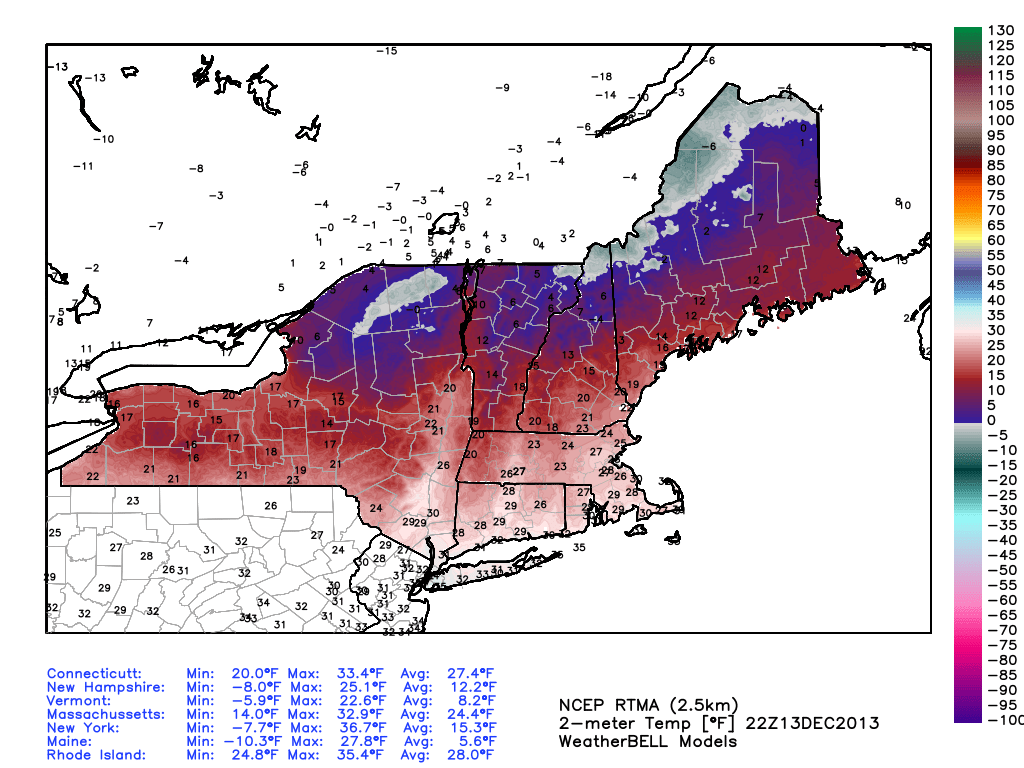
Evening temps across the Northeast...brutal up north! Courtesy: WeatherBell
The Timing...
If you have plans on Saturday (and let's face it, two weeks before Christmas who doesn't?) - I would not cancel them. Specifically during the day and early evening hours. There will be a couple things going on, but nothing so impactful as to keep you stuck with cabin fever. One thing we'll keep an eye out for are ocean-effect snow showers, which may perk up before dawn even comes. This is due to very cold air flowing over the ocean toward the eastern parts of Massachusetts as winds turn to the NNE. Accumulation should be fairly limited with these.
The main synoptic-scale storm will be heading up from the Ohio Valley during the afternoon. By early afternoon, heavy snow will be flying in Philadelphia and New York City. Travel there will certainly be impacted. I'd expect some PM delays at airports in that corridor like PHL, JFK, EWR, LGA, and HPN. Some light snow will break out closer to our neck of the woods as we head toward evening. I think the rate of that snow will be light. It will stick to roads, but with the low rate of snowfall I think any savvy New Englander will be okay. It's the ride home we're more worried about.
Snow intensity will increase, especially after 8pm or so. Those with holiday parties or plans out on the town will want to check in with us during our evening newscast and keep an eye on their radar apps to make sure they're in a comfortable spot before the snow picks up. Because once it does, it's really going to come down!
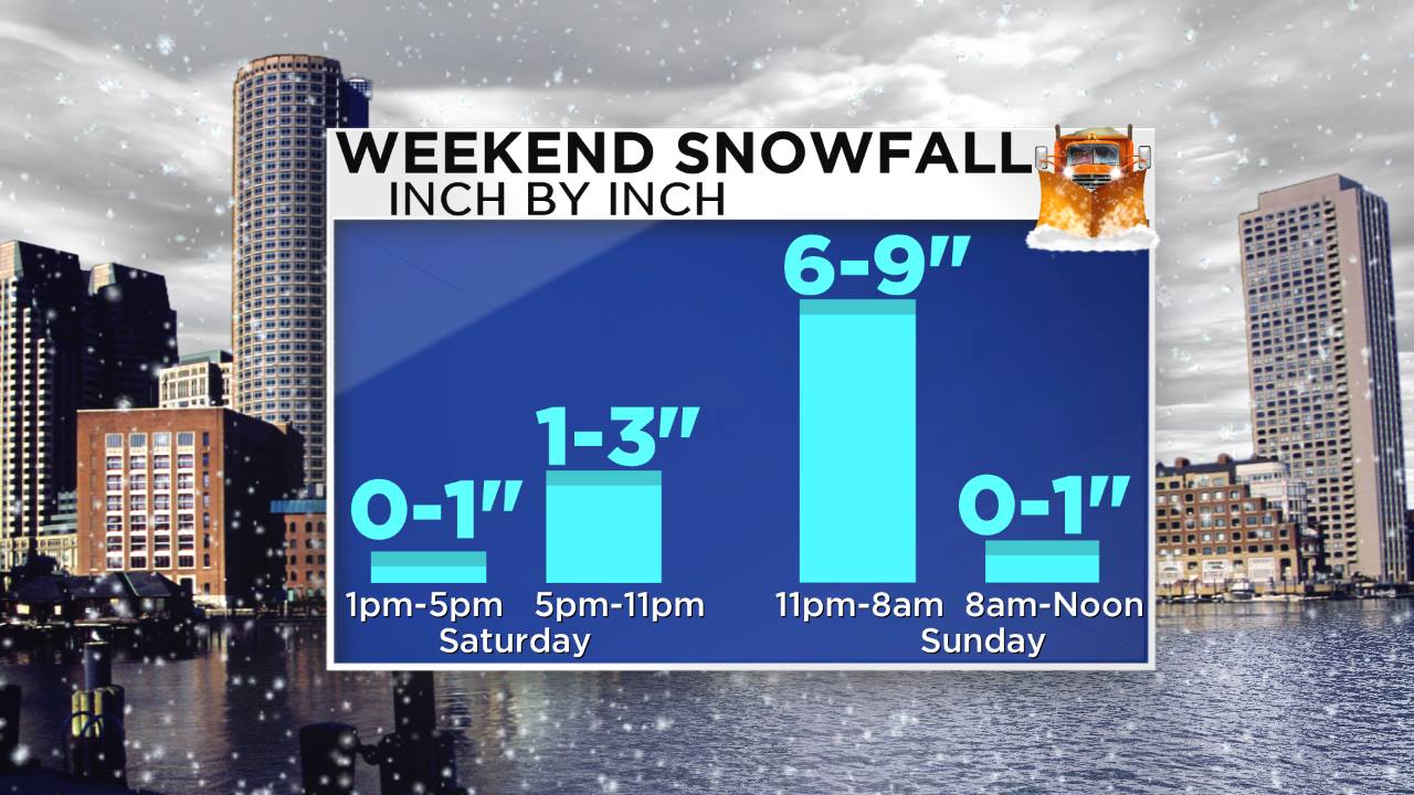
The heaviest burst and 'peak' of the storm is expected to be midnight-8am. This is essentially where the vast majority of the accumulating snowfall will occur. Drier air will very quickly chase this storm out to sea. I'm thinking that all of the snow/rain will probably be gone by 10am at the latest. Below is a graph showing the breakdown of total snow, and during which periods of the day/night it will stack up. Hopefully this helps you plan!
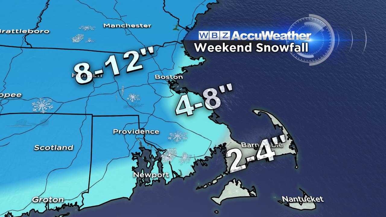
Snow Totals & Precip Type...
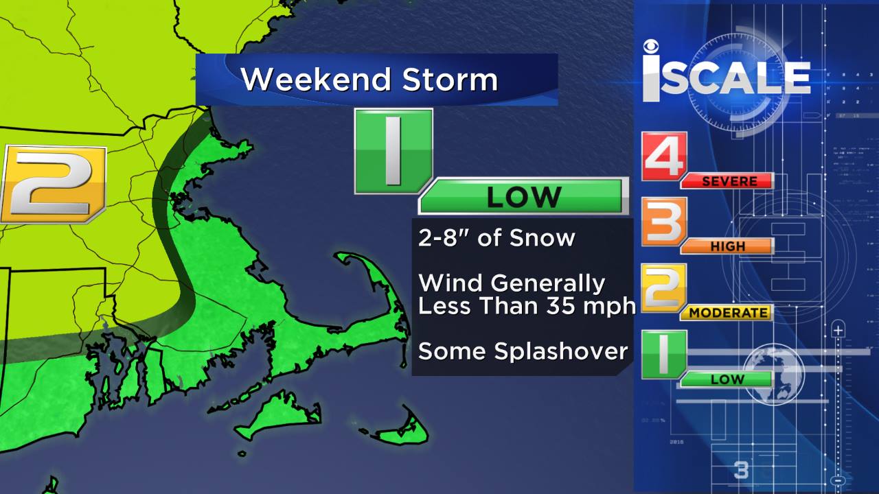
The only change over the past 24 hours in terms of the data we're looking at is that it appears there will be a little more QPF (precipitation) squeezed out from this storm. We upped our forecast just a little bit to reflect this. While a solid snowfall for the interior looks like a very good bet, it's a little trickier (as always) closer to the coast. During the storm our winds will turn due east, and the Atlantic nearby has water surface temperatures in the low/mid 40s. This will help push milder air ashore and change snow over to sleet and rain as Saturday night/Sunday morning wears on. For that reason, I'd expect a tight gradient near the shore where early snowfall gets washed out a bit by rain before the storm ends. This will be felt most strongly from Boston to the South Shore. Totals there may top 4" early with the initial thump of snow, then get compacted/melt as the mix moves in. Any periods of sleet and/or freezing rain would be short enough to keep downed limbs or lines from being an issue.
For the Cape & Islands - an initial blast of snow Saturday night will change over to rain as a tongue of milder air moves in both at the surface and aloft. 850mb temps will go above freezing, and surface temperatures may briefly jump into the upper 30s/40s. That's why we have these areas in the 2-4" range. I wouldn't expect to see too much on the ground come Sunday morning, especially for the Lower Cape & Islands.
Coastal Impacts...
The National Weather Service has issued a Coastal Flood Advisory for all of the MA shore except Martha's Vineyard and the South Coast. Any flooding looks to be minor, with a surge of about 1.5'. Some splashover is expected but major impacts are not as the storm is rather fast-moving and not as intense as, say, the blizzards we saw earlier this year.
Winds will pick up as the storm strengthens - and may gust to 40mph at times early on Sunday morning (after midnight, before 7am). These onshore winds may cause a scattered outage or two, but typically this is not strong enough for significant issues near the coast. Inland winds will be weaker, and so power outages in general are not going to be a big calling card of this storm.
Bottom Line...
A Saturday where most of your plans should be fine, a Sunday where you wake up to snow but most of the storm is ending, and a cold day to end the weekend and dig out. A great one to watch the Patriots play in tropical Miami, as a matter of fact. This is definitely in the 'moderate' category so far as New England storms go, but not a blockbuster. And for many folks, the first time you're breaking out the shovels and snowblowers this year! While it's never great for business or plans to have a winter storm, I think the impacts will be limited due to the timing of heaviest snow, sleet, & rain.
Ski areas will do very well with this event. A widespread 6-12" will be falling across much of New England and New York - all of it light and fluffy in the mountains. So after a streak of very cold air and great artificial snow making, the natural stuff will provide a POWDER DAY on Sunday. With the early departure of the storm, hopefully you can make it to the slopes! Cold air sticks around through at least Thursday of next week and so not much melting will be going on in these parts. In fact, Monday and Tuesday are looking well below average yet again.


