Eye On Weather: The I Scale - How It Works
BOSTON (CBS) - A big storm, but on a Saturday night.
Not much snow, but a lot of ice.
Mostly rain, but major surf.
No two storms are created equal, but they all have one thing in common - IMPACT.
In New England, we are accustomed to measuring each storm by the amount of snow it will drop, but the true measure of a storm should encompass more than just snowfall amounts, it should measure how the upcoming storm is going to IMPACT you.
How will it affect your commute? Will it be heavy or light snow to shovel? Is there a potential to lose power? The WBZ-TV Weather team has designed a new scale, The I Scale, which will help you plan ahead and be better prepared before the first flakes fly.
It was important to us to make sure this scale wasn't some arbitrary thing we make up for each storm.
Below is a list of specific criteria that we will consider before issuing an I Scale forecast. Keep in mind that in many cases the I Scale values will differ from region to region. In other words, what might be a 4 in one location could be a 1 or 2 in another.
The I Scale ("I" stands for Impact) has four levels.
Level 1: Low Impact
Level 2: Moderate Impact
Level 3: High Impact
Level 4: Severe Impact
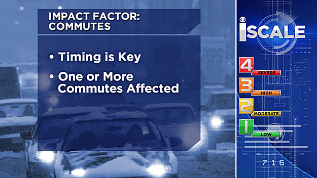
IMPACT: TIMING
There is a big difference between snow falling during a commute and snow on the weekends. We have all seen that just a few inches of snow falling at just the WRONG time can make your life in the car miserable. So, therefore, the timing of a storm event is one of the factors we will consider on the I Scale.
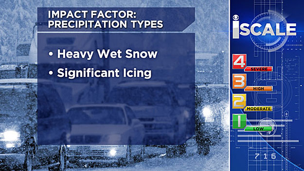
IMPACT: PRECIPITATION TYPE
If you have to clear your own driveway, by shovel or by snowblower, you know that a light fluffy snow is a lot easier to take than a heavy, wet, cement-like snowfall. Just a small amount of ice can also wreak havoc on the roads and on your front steps. Therefore, precipitation type, from fluffy snow to sleet and ice is another important factor on our I Scale.
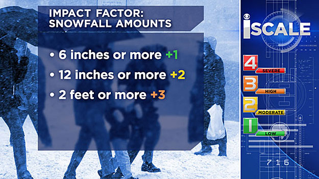
IMPACT: SNOWFALL AMOUNTS
Something we are all familiar with, the dreaded snowfall accumulation map.
Will you be in the 1-to-3 inch band or the 6-to-12 inch zone?
We have a pretty big range of possibilities here in southern New England when it comes to snow amounts.
Here is how they will be broken down within the I Scale:
6 inches or more = +1
12 inches or more = +2
2 feet or more = +3
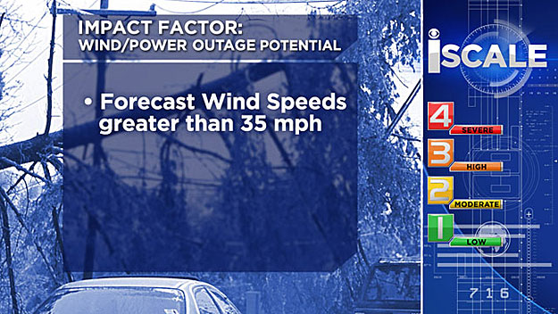
IMPACT: WIND AND POWER OUTAGES
Yet another important piece to any winter storm puzzle is the wind and power outage potential.
Typically, wind speeds greater than 35 miles per hour are going to cause problems no matter what season you are in, many times leading to power outages as well. So the wind also deserves a mention on our I Scale.
IMPACT: COASTAL FLOODING
Finally, we have a factor that is not relevant in every location, but for coastal residents it is a major concern - coastal flooding. Many times this factor alone can be the difference between a minor event or a major one where life and property are at risk.
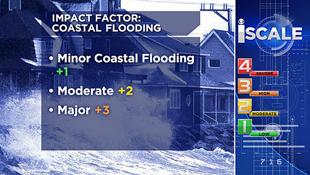
Therefore, much like the snow amounts, coastal flooding can add multiple numbers onto the I Scale as seen below:
Minor Coastal Flooding =+1
Moderate = +2
Major = +3
So now to break this all down into one handy dandy I chart:
| IMPACTS | LEVEL ON SCALE |
|---|---|
| Timing (commutes affected) | +1 |
| Heavy Cement-like Snow | +1 |
| Significant Icing | +1 |
| 6+ Inches of Snow | +1 |
| 12+ Inches of Snow | +2 |
| 24+ Inches of Snow | +3 |
| Power Outages,Winds 35 mph+ | +1 |
| Minor Coastal Flooding | +1 |
| Moderate Coastal Flooding | +2 |
| Major Coastal Flooding | +3 |
Lastly, I know what you might be thinking - this is going to add up to more than 4 at some point right?
While that is possible, anything that reaches the level of 4 or higher is going to be a severe event. So 4 is the limit on the I Scale, once the numbers add up to 4, it will be classified as severe, period.
MORE LOCAL NEWS FROM CBS BOSTON


