The Winter Outlook
Winter is clearly the most challenging season of the year for us weather forecasters. Short-term prediction is tricky business because of the chaotic nature of the fluid atmosphere and that will probably always limit our ability to specifically predict the weather with any high degree of confidence beyond a theoretical threshold of 7-10 days. Nevertheless, we all have a curiosity about the future and most people wonder what the impending winter is going to be like more than any other season.
Based upon the present and predicted indices of the various climate factors and considering analog years, the WBZ Weather Team presently projects an overall winter delivering:
1. NEAR TO ABOVE AVERAGE SNOWFALL
2. NEAR TO BELOW AVERAGE TEMPERATURES
That doesn't suggest that every day will be close to the average or colder than average but the months of December, January and February all look to have a mean temperature below average. We expect more flucuations in the temperatures going forward similar to what we have experienced in November. Overall, in the end, the mean temperature for the entire season is more likely to be lower than average unlike last year. In the same way, it is indeterminate how many snowy days will occur but the dominant factors seem to be signaling near to above average snowfall for the whole winter in most of New England. For Boston, the average snowfall is 43.8 inches and our present thinking calls for at least 45-50" around the city which is in the ball park of the snowfall in the closest analog year of 1969-70.
Statistics reveal that no two consecutive winters are exactly alike. In fact, they can be a study of contrast such as Boston's 9.3" of snow in 2011-12 followed by 63.4" last year. The main drivers for this winter indicate no extremes meaning no super persistent warmth like two years ago when the mean temperature for the season was a whopping, record-breaking 6.2 degrees above the average yielding the second least snowy season of the last 140 years! On the flip side, long-lasting, relentless cold producing several record or near record low temperatures as in January 2004 is not foreseen either. The key variables are not favorable for high seasonal snowfall totals such as Boston's record 107.6" in 1995-96 and even the 81" in 2010-11.
 The fascination of seasonal forecasting is naturally linked to a huge variety of socio-economic applications. The accuracy of seasonal weather prediction has improved significantly thanks to the work of brilliant scientists in and out of the government sector who have discovered an amazing connectivity between the oceans and the atmosphere. They have identified well over a dozen prime global factors that influence seasonal climate forecasting for various locations. These include specific atmospheric and oceanic oscillations such as ENSO, the NAO, the QBO, the PDO, the PNA, the EPO, the TNA, the AMO, the MJO, etc. The permutations in the phases of these numerous oscillations, the solar cycle, geomagnetic activity, recent volcanism, storm track data, fall temperature and precipitation patterns plus the extent of snow cover from Siberia into western Canada and the ice coverage in the Arctic Sea all play a role. It is a veritable atmospheric Rubik's cube and the finesse is figuring out all of its intricate twists and turns.
If you desire a more technical, detailed analysis, continue reading through the rest of the this blog. Reviewing last winter, we had prognosticated slightly below to near average snowfall with a risk that 1 or 2 storms tucked closer to the coast could enhance the seasonal total above the average. That risk was predicated upon the development of blocking high pressure in the Greenland/Davis Straits area. This is the negative phase of the NAO which is one of the most paramount pieces of the puzzle and more difficult to forecast months in advance. The degree of severity of our winter is linked to this phase which shoves the jet stream farther south leading to potential coastal storms from the Mid-Atlantic States to New England. This phase was the catalyst for the major blizzard in early February 2013. Although a storm of that magnitude cannot be totally ruled out, the probability of a near repeat this winter is very low. Last year's temperature prediction of below to much below average temperatures failed in part due to the expectation that the NAO phase would become negative early. The negative NAO is associated with the buildup of polar high pressure and upper level warming which shifts the cold air farther south toward into the parts of the mid-latitudes. Last year's signals indicated that a sudden stratospheric warming would develop and that often causes the collapse of the NAO into negative territory. Once this finally formed last year in early December, there was an unusually long delay of any impact on the weather because the pressure rises in the polar region did not push down from the stratosphere into the critical 500 millibar level right away and we need to understand this relationship better to more accurately forecast the season. Sudden stratospheric warmings typically commence with a bubble rising into the stratosphere in South Central Asia and that action triggers a disruption and sinking into the Polar Region. Presently, however, there is no concrete sign of this disruption. Furthermore, there are some contradictory signals from several of the various indices in terms of dominance relating to the formation of the negative NAO. Consequently, while there have been enormous strides in seasonal forecast accuracy, there can be unforeseen wildcards that can overrule all other indices and spoil the forecast. This occurred in 2001-02 when a projection of a rough winter went bust because the solar flux surprisingly and suddenly spiked which shrunk the polar vortex and resulted in a zonal flow of very mild air across our nation and southern Canada. And more recently in 2011-12, no blocking developed because a disrupted warm pool in the North Atlantic stopped the blocking from expanding westward from Europe and the eastern Arctic into Greenland. Another player in that winter was the presence of cold water in the northeast pacific especially the Gulf of Alaska. Conversely, we now have a warm pool in this area and combined with sea surface temperatures rising in the central tropical Pacific, it is favorable for colder to much colder than average weather into the northern portions of the nation including the Northeast. With a resultant negative phase of the WPO/EPO unfolding, a ridge amplifies over Alaska yielding a colder than average scenario over the central and eastern portions of North America. Additionally, following last year's ENSO-neutral or warm-based La Nada or weak El Nino, there are now some signals that El Nino may slowly become a bit more pronounced by late winter or spring leading to perhaps a stronger El Nino in late spring and summer. This potential development favors a more harsh winter and cooler summer. So while we have factors in similar phases and dominance as last year, there are also some dissimilar indicators and that makes this season challenging. For example, the QBO has flipped from easterly last year and is now westerly at its peak amplitude as it begins decreasing through the winter and spring and flips to easterly next summer. This in tandem with a weak solar index suggests a colder regime. Other differing players now over last season include the marked increase in Eurasian and North American snow cover which favors a more harsh winter plus the much more extensive coverage of ice in the Arctic Sea which favors a more negative NAO. The geomagnetic activity remains very low and that favors the sudden stratospheric warmings yielding a -negative NAO regardless of the direction of the QBO. However, the geomagnetic cycle should be approaching a rebounce so this is a bit of a wildcard this year as well. The AMO and TNA remain positive and that generally encourages the -NAO. The PDO remains in the very cold phase and combined with some of the other factors, entices a colder and stormier regime. High latitude volcanic eruptions are favorable for high latitude blocking and there have been some sizeable eruptions from 4 active volcanoes in Russia in 2013 with a big eruption in October. It appears, however, that there was not a significant penetration of the aerosols/ash into the upper atmosphere.
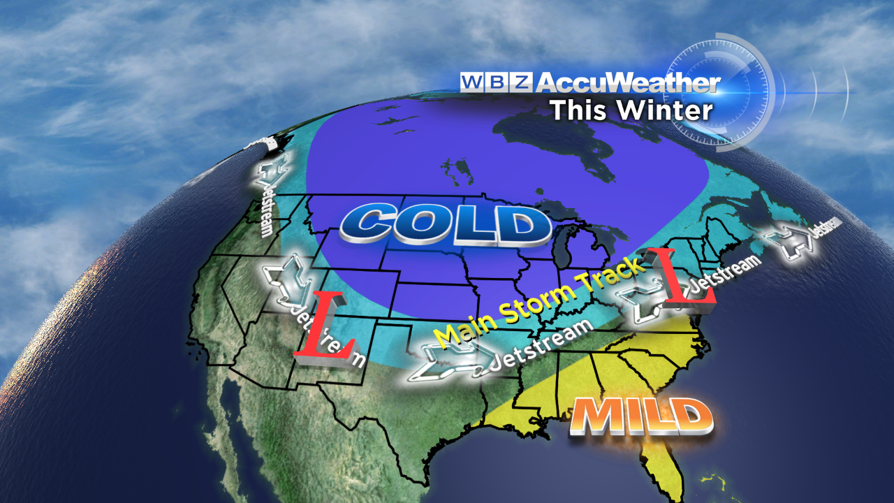
In conclusion, the signals are flashing the potential for widespread cold in the nation this winter with mild air in control over the southeastern states. The extent and intensity of the cold air masses in Canada over the past several weeks is astonishing so it appears that we will be close to this corridor of cold for some time to come. Eventually, this will lead to storms riding along the boundary of this unusually cold air. The main storm track will waver leading to some bursts of mild air and bouts of chill. The cast of characters is large and we will be watching closely for any twists in the plot.
For many years, the WBZ AccuWeather Team has learned much about the global climate, seasonal forecasting and its variability by following the highly respected meteorologist, Joe D'Aleo. His extensive research and knowledge of this complex field is nothing short of extraordinary. We thank Joe for his commitment and guidance. You can follow the work and findings of Joe D'Aleo and Joe Bastardi on WeatherBell. For more fascinating information on climate change, visit Icecap.
Finally, you can enter the WBZ Snowfall Contest and guess the amount of snow that will fall at Boston's Logan Airport in the period from October 1, 2013 - April 30, 2014. The winner receives a season pass to Mt. Wachusett for the 2014-15 season plus a new Toro snow blower! Good Luck!
With 100% certainty, astronomical winter begins with the solstice at 12:11 pm on December 21st.
Have a great winter!