Major Storm Threatens Holiday Travel In Northeast
BOSTON (CBS) - If your travel plans are taking you anywhere along the East Coast over the next few days (I'm sure that covers just about all of you), you will want to pay a little extra attention to the weather forecast.
Check: Current Conditions | WBZ Weather Blog
Thankfully, the snow will not be a major concern this go around, but a whole lot of wind and rain are expected to cause numerous delays from the Gulf Coast to New England.
This storm started to cause trouble in the Desert Southwest and in Texas over the weekend. A mix of rain, snow and ice led to numerous accidents and delays. Currently, the storm is located on the Gulf Coast and gathering up loads of moisture, poised to soak the entire East Coast.
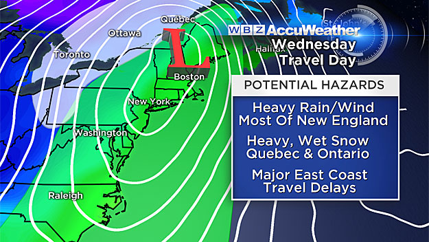
Here's the timeline:
Monday Afternoon & Evening: Significant rainfall expected in Gulf Coast areas and some snow on the northern fringes of the storm possible in southern Illinois and Kentucky. Major cities affected include: Houston, New Orleans, Memphis and Little Rock.
Tuesday Morning: Folks in the southeastern U.S. will wake up to heavy rain and potentially some severe weather. Major cities affected include: Atlanta, Tallahassee, Nashville and Charlotte.
Tuesday Evening: Some of the major cities in the Northeast will get in the game, just in time for the evening commute on Tuesday. Drenching rains expected from Charlotte, North Carolina to Washington, DC to Baltimore and Philadelphia. On the west side of the storm, there will be some accumulating snowfall in Cleveland, Buffalo and perhaps Pittsburgh on Tuesday night.
WBZ-TV's Lauren Leamanczyk reports
Steady rain will arrive in southern New England Tuesday night, likely just after the evening commute. It may start as a brief period of snow or mix in far western Massachusetts (The Berkshires) and parts of southern Vermont and New Hampshire, but it won't last long, it will change to all rain overnight.
Wednesday Morning: It's our turn. The storm finally arrives in full force in New England. It will be raining very heavily for about 12-to-16 hours, from about midnight through mid-to-late afternoon on Wednesday. In fact, we are likely in for about 2-to-3 inches of rainfall. The one saving grace here is that warm air will be flooding in along with the rain. Temperatures on Wednesday will soar to near 60 or higher as the storm system draws up mild air all the way from the Gulf region. Some bad news for skiers, this will fall as rain in pretty much all of New England. Snowfall will be confined to extreme western New York State and perhaps just the far northwestern portions of Vermont.
Wednesday Evening: The storm is flying up past Nova Scotia and much colder air will once again be pouring into New England. Thanksgiving will be the first of several, cold and dry days, with temperatures barely in the 30's with much colder wind chills.
You can follow Terry on Twitter at @TerryWBZ.
MORE LOCAL NEWS FROM CBS BOSTON