Early Look At Thanksgiving Travel Forecast Shows Storm On The Way
BOSTON (CBS) - It sure has been quiet around here lately wouldn't you say? We haven't had a significant weather event in southern New England for months. We are running a rainfall deficit, enough to put us in what has been termed a "short term moderate drought."
Check: Current Conditions
I guess you could say that we are due. It might be time to "pay the piper" as they say, just in time for the holiday.
WHAT'S ON THE WAY
First, we have a significant blast of Arctic air headed our way later this weekend. This will arrive along with a few snow showers Saturday night and by Sunday morning it will feel like the dead of winter. High temperatures on Sunday will struggle to reach 30 degrees and with winds gusting well over 20 mph it will feel like 5-to-15 degrees most of the day!
Next, we will be watching the Gulf of Mexico for the development of a storm. It will have origins in the southwestern United States and then pick up a significant amount of moisture from the Gulf.
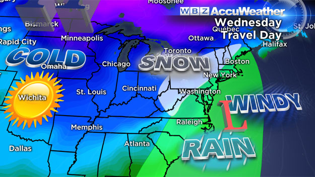
By Tuesday, the storm will really begin to take shape over Florida and begin the ominous turn to the north.
This is where our weather models begin to diverge.
The big question is - will the northern and southern jet streams merge and draw the storm all the way up the East Coast or will they remain separate and kick the storm out to sea south of us?
At this time, we are favoring a merge of the jet streams and a significant coastal storm for southern New England. There is obviously plenty of time for adjustments in the forecasts, so if your plans have you traveling anywhere on the East Coast early next week, I would advise you stay tuned to future forecasts.
Should this worst case scenario happen here is what we may be in for here in the Boston area:
TIMING
Largely a Wednesday event, potentially affecting both commutes
PRECIPITATION
At this point (and it is very early), I would favor rain in eastern sections and a mix or snow well inland. Where exactly that rain-snow line would setup is still very much up for grabs. However, it is very difficult to get a significant snow event in Boston in November due to the mild ocean waters this time of year.
WIND-COAST
Winds would certainly be a factor should this storm come north. It would feel much like a typical nor'easter with potential for strong gusts from the east-northeast, leading to rough seas and the chance of some minor coastal flooding. Tides are not astronomically high next week, so major flooding is not a concern at the coast.
I stress again, there is still a long way to go with this storm and lots of atmospheric twists and turns are certain. If you have the chance to travel earlier in the week (Monday or Tuesday) as opposed to Wednesday, I might start to consider that option.
And of course stay tuned to updated forecasts throughout this weekend.
You can follow Terry on Twitter at @TerryWBZ.
MORE LOCAL NEWS FROM CBS BOSTON