The Winter Hammer Falls By This Weekend
Find Eric Fisher on Twitter and Facebook
Programming note: We finished shooting our Winter Weather Special today! The whole team was in the house, now we just have to glue all the pieces together. This will air on WBZ-TV at 730pm on Saturday, November 30th. Hope you join us...we'll have our winter season forecast, talk about some new technology going in state roads, take a ride with the U.S. Coast Guard, and introduce a new scale to help prepare for winter storms.
Courtesy: Terry Eliasen, WBZ-TV
Sure it's chilly out, but what's your definition of truly cold this time of year? 40s? 30? Nights in the 10s? That's the funny thing about weather - it's arbitrary! We all have our own personal definitions of what hot & cold, showers & rain, windy & breezy all actually mean. But I'm willing to bet that the majority will consider it 'winter' by the time Sunday rolls around.
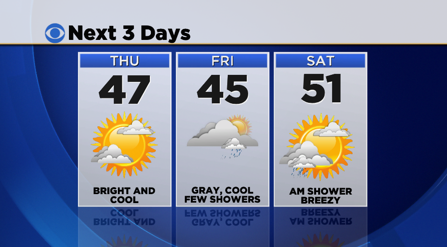
The short term is pretty boring stuff, so I won't go on too long about it. Cold tonight in the upper 10s to mid 20s, and chilly tomorrow with a mix of sun and high cirrus clouds. The good news is that even though temperatures will still be a touch below average (43-48) on Thursday, bright skies and light winds should make it feel fairly comfortable. Plus, those cirrus clouds should make for another excellent sunset.
Friday is looking gray, damp, and cool as a weak front approaches. For the moment I'm calling for mostly cloudy skies, a couple light rain/snow showers around throughout the day, and highs in the mid 40s. One of those typical 'blah' November days that we tend to see quite a few of in most years. This is yet another moisture starved front with limited forcing in the atmosphere, so we'll see a couple more showers Friday night into the very early hours of Saturday, but that's about it. Nothing much to dent our rainfall deficit this autumn.
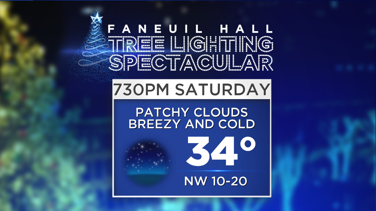
Alright - now we get to the interesting stuff. The highest confidence portion of the forecast is the temperature side. We get a break to start out with - the first front that swings through Saturday morning will not bring in all the cold air. A mainly dry, breezy, and seasonable day will handily make it the pick of the weekend for anything outdoors. So sneak it in while you can! We're also looking good for the big tree lighting at Fanueil Hall, which up to 30,000 are expected to attend! If you can't join us, you can watch it live on WBZ-TV starting at 7:30pm.
On Saturday night a secondary cold front will be passing through, and this one means business. Behind this is what could end up being the coldest air we've seen since February, with 850mb temperatures plummeting to a frigid -17ºC by Sunday evening! That translates to temperatures barely reaching the freezing mark, if they even get there in some towns. Plus, there will be strong NW winds gusting over 30mph, leading to wind chills in the teens and single digits by sundown. In short, the perfect day to bundle up the cozy confines of your home, bake something delicious to smell up the house with, and watch football. A fire in the fireplace wouldn't hurt, either. If the cold air arrives in time and we somehow manage to stay below freezing for a high temperature in Boston, it would be the first time we've stayed that cold since the day after the massive February blizzard. And if you're planning on going to Foxboro for the big Patriots Sunday Night Football match-up, bring extra layers! It will be absolutely frigid with wind chills in the single digits at kickoff. A feel of January (and hopefully playoff) football in the air.
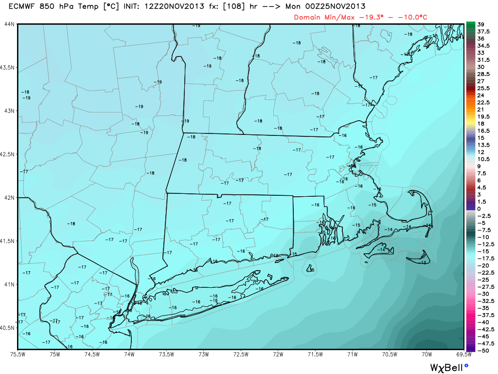
Courtesy: WeatherBell. T850mb by Sunday evening.
A massive area of temperatures 15-30º below average will be setting up by Monday morning, and departures like that hurt this time of year. I expect some towns will be in the single digits by the start of next week, with widespread 10s otherwise. This burst of cold air will also come with snow showers, especially on Sunday. Many should get a chance to spot snowflakes, although accumulation would be pretty limited outside of the mountains. I'll also keep an eye on the ocean-effect setup. The trajectory isn't perfect, but with air that cold it could end up being a snowy Sunday on the Cape & Islands. Again, not expecting major accumulation, but could be interesting! The Sunday/Monday wind trajectory will also be great for NW facing slopes across Vermont, Massachusetts, and New York in particular. Some of the ski areas should get pasted with fresh powder; and with long-term cold setting up the snow guns will be maxing out efficiency. A Thanksgiving trip to the slopes should work out just fine.
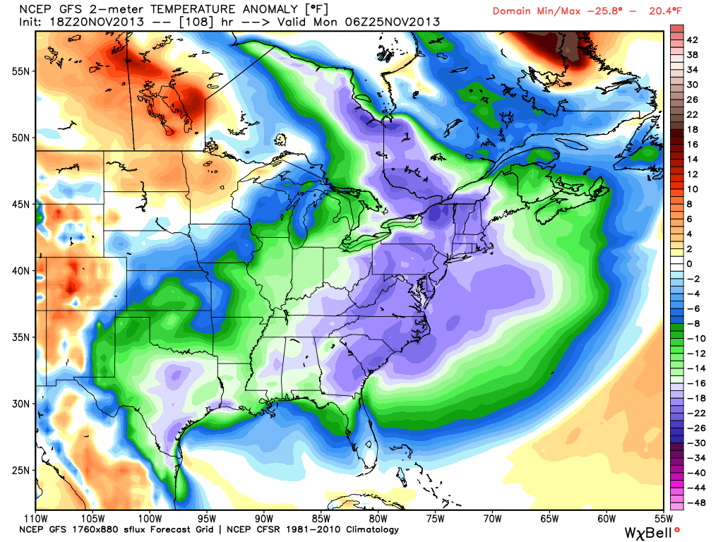
Courtesy: WeatherBell. Temps 15-30º below average across the eastern U.S.
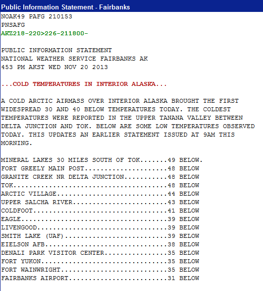
To make you feel better about this impending cold snap...here's a look at Wednesday's temperatures in Alaska via the NWS office in Fairbanks. Yep, could be worse! This is part of the air mass that will head into the lower 48 this weekend.
We'll stay very cold on Monday, and still quite chilly on Tuesday. An area of low pressure swinging around to our NW will bring another chance of snow showers/flurries Monday night and early on Tuesday. Then we'll start to address a potential coastal storm. This is one of the first instances this season of the subtropical jet being involved, as an anomalous cut-off low moves into the southwestern U.S. This southern stream energy will move through the Gulf Coast states and strengthen, bringing a severe weather threat and a dousing of rainfall. That's the *high confidence* part of this equation.
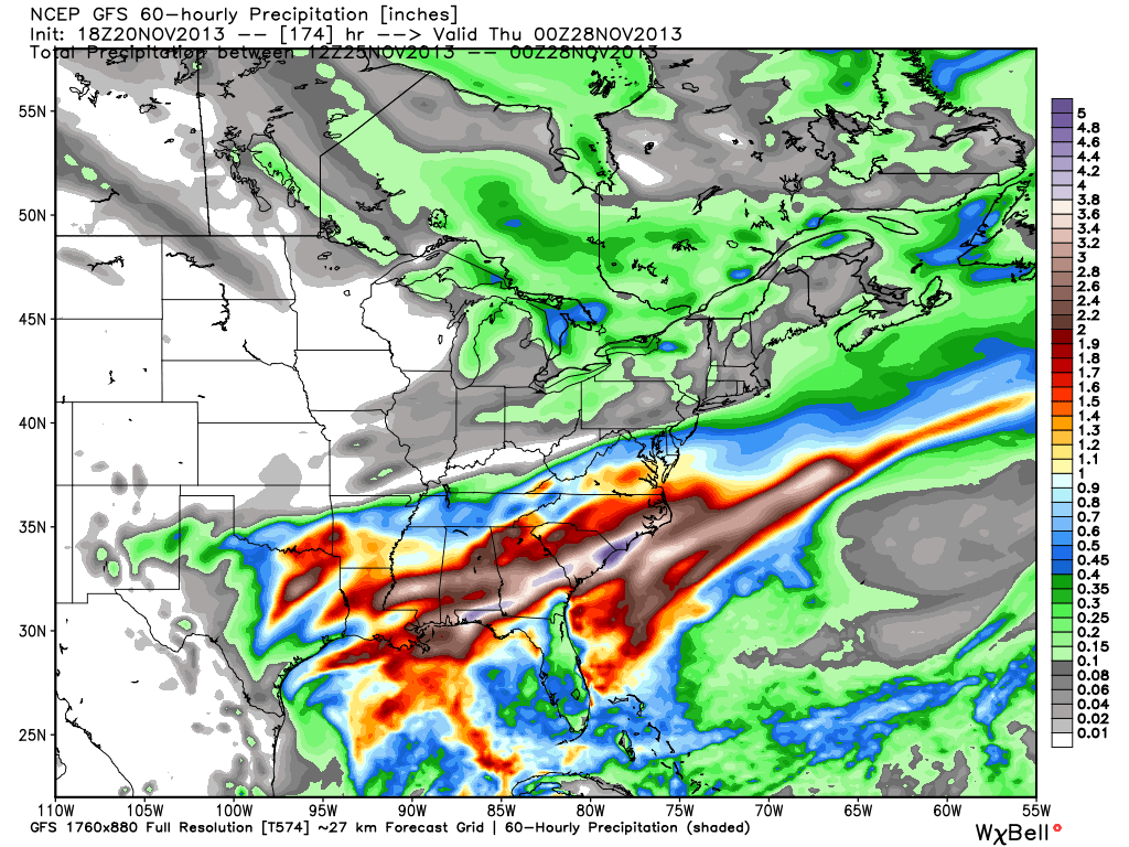
Courtesy: WeatherBell. Widespread 2-4" rain totals across the south early next week
Then the proverbial question is one of track. Models, as they tend to do, are oscillating between different solutions right now. The ECMWF has been trending with a more inland solution (more precip for us)...but it has also been terrible in accuracy lately. The GFS is more OTS (out to sea), but is still close enough to be of concern. We know that since this storm will be making a pitstop along the Gulf, it will be bringing plenty of moisture along with it. And that moisture will indeed move up along the coast. It's still a little too far out to say with any confidence where exactly all that rain/snow will fall.
I'm inclined to say OTS for now, for two reasons. One being that the trend has been offshore with recent events after days 6-8 in the models. The other is that high pressure will be located to the west of the storm track, in lieu of a strong 'blocking' high to the north. You can see the current MSLP forecast for this time frame, and the storm will likely be traveling fairly rapidly between the Atlantic high and Midwest high. If it's near the benchmark (40ºN 70ºW), then it should be plenty cold enough for mainly snow.
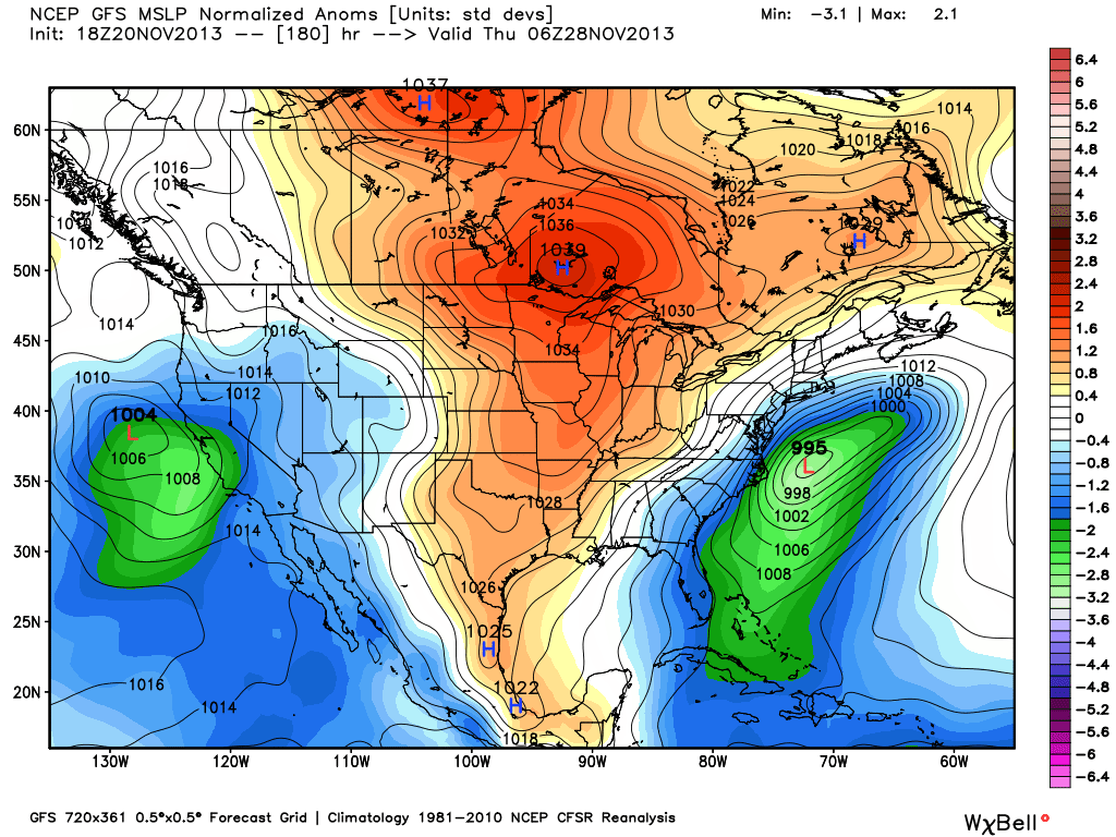
Courtesy: WeatherBell. MSLP anomalies for next Wednesday
But with all that said, the time frame for this is during one of the busiest travel days of the year and a major holiday. So of course, we'll be monitoring the trends over the next few days. Wouldn't it just be typical if we had 4 months of tranquil weather to be followed by one storm on Thanksgiving? Whether it's a hit or a miss, it will still be very cold on Thanksgiving and especially on Black Friday. I wouldn't want to be a shopper camping out on Thursday night. I don't foresee any significant warm-ups through at least early December. The cold will definitely have all in the holiday spirit to start blaring the Christmas tunes and cutting down the family tree. Winter has arrived!