Cool & Quiet Week Ahead After Midwest Tornado Outbreak
Find Eric Fisher on Twitter and Facebook
Programming Note: Tune in for the WBZ 'Eye on Weather Winter Preview' on Saturday, November 30th at 7:30pm. A look at communities rebounding from last winter, new technology going into Massachusetts roads, our winter weather forecast, and a new system for rating the impact of upcoming winter storms.
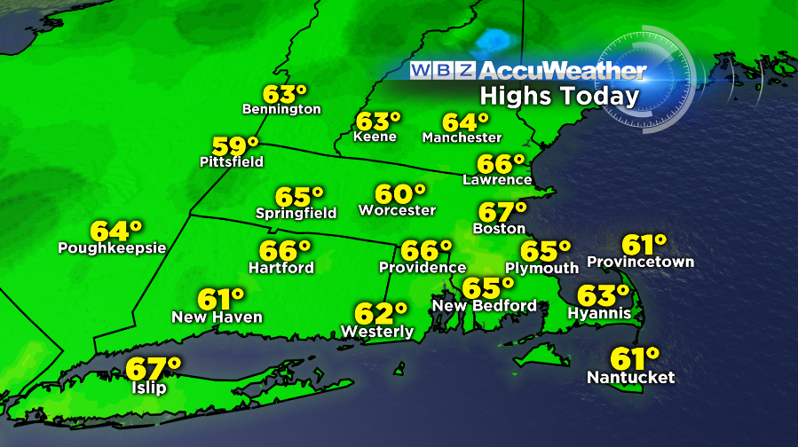
Quite an interesting way to start the week! From a burst of heavy rain just in time (of course) for the am commute, to spectacular afternoon weather with spring-like highs in the 60s. And now, here comes the cold. It's lingering behind a secondary cold front, which will make its way through tonight. And by the time you head on out tomorrow, it will feel a whole lot different out there than it did on Monday. But we knew weather like that couldn't last for too long this time of year.
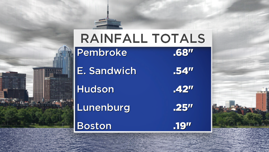
Rain totals weren't spectacular, but at least enough to moisten up the ground a bit and lower our brush fire danger for a short time. We're still running a significant deficit, ~7", since the start of August in the greater Boston area. The rain that came through was actually a part of the same storm system which brought widespread severe weather to the Midwest on Sunday (more on that below) And it's a good thing we managed to get some rain out of this system, because there isn't any more on the way for the rest of the week. The only caveat to that is the chance for a few light rain/snow showers overnight tonight, which are most likely to occur over the higher terrain of the Berkshires, Monadnock Region, and southern Vermont.
The Week Ahead:
We'll start Tuesday morning in the 30s, and won't see the readout on the thermometer budge much for the rest of the day. As 850mb temps cool to about -8ºC, highs will stay stuck in the upper 30s across the higher terrain to low 40s elsewhere. While not anything too wild for mid-November, it will definitely feel a whole lot colder compared to the balmy 60s of Monday! With a gusty WNW wind 10-25mph, wind chill values will be in the 30s and perhaps even some 20s for the highest terrain.
The coldest night of the week will be Tuesday night, with widespread 20s on the map. Abundant sunshine on Wednesday will help get us off the turf and into the mid 40s during the afternoon. Plus, with high pressure cresting over the Northeast, there will be much less wind to contend with. Thursday looks cool and peaceful as well, with highs in the 40s to around 50 and a mix of sun and high clouds. By Friday the next storm system will be reaching its tentacles toward us in the form of a warm front, which should make for cloudier skies and perhaps even the risk for a few showers. Still a bit too early to tell if we'll have to use the umbrellas on Friday just yet, so stay tuned on that end.
Active Weekend Forecast:
The weekend is where the action will be, as another big storm system gets cranking and starts moving toward the Great Lakes. The question for now is one of timing and location. The GFS takes a track more toward our NW and is milder. This is the trend of many storms over the past few months, and so I'm inclined the ride the trend until something dramatic happens to change it. The ECMWF takes the center a little closer to us in New England and draws in more cold air, which is leading to a solution of snow for many areas of New England. For the moment, temperatures look pretty marginal and the ECMWF has done poorly in the medium-range forecast, but it bears watching as we move through this week. Either way, rain *or* snow will fall on Saturday to kick off the weekend in New England, likely a combo of both.
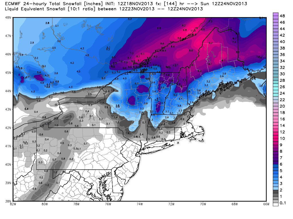 November 18th, 12z ECMWF forecast for snowfall totals this weekend. It's still much too far out to tell how this system will play out. What this basically says is that we should monitor the weekend storm and there's the potential that snow will come out of it across New England. Stay tuned!
After that, it's all about the COLD. A blast of Arctic air will move in by Sunday and linger into the start of next week. Now with the most recent system, guidance was pointing to very cold air...but the trend moderated as we got closer to the event. We'll see if the same occurs with this system. But for now, I'm banking on a wintry Sunday and Monday on tap with gusty northwest winds and some mountain snow up north. Cold is expected to be the predominant word heading into the end of November and beginning of December, too. Below is the GFS Ensemble Mean, showing a very chilly Nation east of the Rockies during that time frame.

Tornado Outbreak in the Midwest:
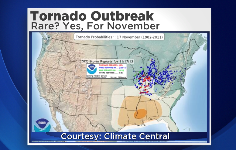
The last note tonight is on the Sunday tornado outbreak across the Midwest. The National Weather Service in Chicago has put together a comprehensive page full of information on the event, if you're interested in giving it a read. The bottom line is that several people were killed, and there were potentially dozens of tornadoes touching down (surveys are still ongoing with full details likely by mid-week). I posted the graphic below on Twitter earlier on today, and it seemed to touch a nerve. At last check, it had received over 300 RTs! The graphic is from the Storm Prediction Center, which issues convective outlooks each day. They have 'slight risk,' areas, 'moderate risk,' and 'high risk.' High Risk is put out when they have very strong confidence of a damaging event. They issued a rare November High Risk for Sunday, and all the dots on the map are of the actual storm reports. I posted it because it shows how excellent severe weather forecasting has become. A tornado outbreak, in the Midwest in mid-November, on a Sunday when many are home, could have killed dozens of people maybe 50 years ago. While some tragically lost their lives in this outbreak, I'm convinced that more accurate and available forecasting is helping to keep many alive.
Climate Central put together this overlay, which shows the tornado climatology for the date and where the storm reports actually occurred. As you can tell, it's rare to have this many tornadoes in that part of the country in mid-November. It lead to the first EF-4 tornado ever reported in Illinois for the month of November (the storm that leveled parts of Washington, IL). There have also been 23 confirmed tornadoes in Indiana as of this writing, making it the 3rd most active tornado day in state history (of any month!).

Incredible photo from the Chicago Tribune. The tornado traveled over farmland, and left this pattern in the fields. You can see the cyclonic rotation of the tornado in the fields, and pick out where suction vortices were as they rotated around the storm! It's a very unique perspective on how this monster moved.
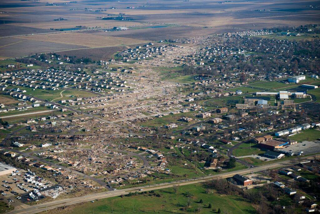
Aerial photo of Washington, IL with huge tornado scar through town. This tornado traveled over 46 miles with a peak wind intensity of 190mph.