Snow & Cold Bring Winter to New England
Find Eric Fisher on Twitter and Facebook
At least it isn't October! We've had some early snows in recent history, so I suppose you could say waiting until November is a nice break. But it was northern New England over the weekend, and now our turn in southern New England to watch the flakes fly.
A potent cold front is rushing down out of Canada, and will bring a blast of Arctic air (briefly) to much of the eastern United States. 850mb temps, which were above 0º for a time today around Boston, will plunge to ~ -11 C by midday Tuesday. What does that mean? We're stuck in the 30s, all day long. That's the average high for January 6th! I know not everyone is a big fan of this type of forecast and that you're already booking your flights to the Caribbean, but not everyone grimaces when the cold starts to take over. I asked "What do you actually like about the cold" on my Facebook page (see link above) and there's plenty of positive thoughts about this changing of the seasons. Feel free to join the conversation!
 HRRR 850mb Temperatures
Here's the timeline:
- 12a-3am: Rain showers will start to move in from west to east. These will first be felt across WMass, Worcester County and SW New Hampshire. Temperatures at this point should still be in the 40s to upper 30s.
- 3am - 6am: Rain showers press toward Metro Boston, while what was previously rain will change over to wet snowflakes to the west.
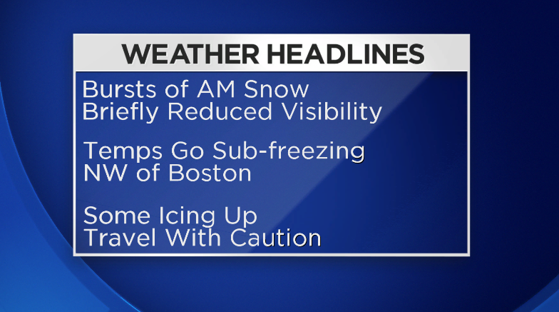
- 6am - 10am: Mainly snow showers across the region, and this is the time frame we're most interested in. The front is expected to be an 'Ana-Front' - meaning the precipitation will be mainly behind the boundary. So that means it will be falling in the cold air, which is why I'm thinking this will be more snow than anything else. While the precip falls, temperatures will be plunging into the upper 20s/low 30s. With moisture on the ground, this leaves room for some flash freezing or at the very least icy spots here and there. The highest chance of this happening is in the hilly areas of Worcester and Middlesex Counties.
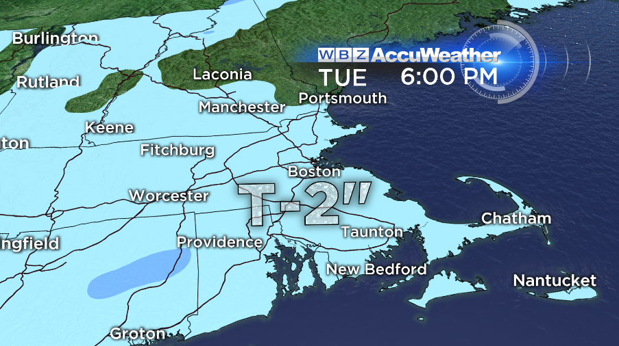
On our side is the fact that temperatures have been warm enough lately to keep road surfaces on the mild side. It will be difficult to get any accumulation to stick on the roads. Most of it will be on grassy surfaces. Total amounts for this event won't be much...but I'm sure there will be some excitement to go with the flakes in the air! The late-nite model data suggestions that the areas with the highest probability of seeing some accumulating snow on the grass are southern Worcester County, northern Rhode Island, and towns between the Mass Pike and the Cape Cod Canal.
The part of this system that we're closely monitoring is the potential for a few bursts of heavier snow. There will be pretty solid dynamics with this front, with considerable frontogenesis (forcing along the front) and nice divergence (air moving up, out, and away) aloft. That, coupled with quickly falling heights, could provide enough 'oomph' to get these squalls going - even with meager moisture. They would bring brief periods of reduced visibility and would help to get snow sticking to surfaces. And you know how it goes - the first snowflakes of the year always seem to cause pandemonium, even here in New England. So check in with WBZ during the morning before heading out to check on the situation, and walk/travel with extreme care during the morning hours. We certainly don't want to see a big mess on the roads, and I always say prepare for the worst case scenario! Being prepared will never hurt you in the end.
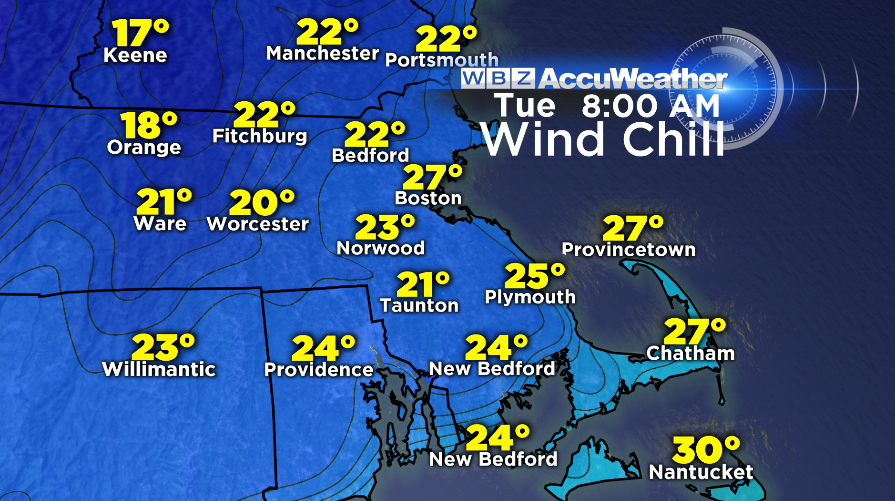
Once the snow clears out (by 2pm for Cape & Islands) the story will be all about the bout of unusually cold air for this time of year. 30s by day and wind chills in the 20s will force us to dust off the scarves, hats, and puffy coats around the region. Some wind gusts could be in the 20-30mph range during the afternoon, and so as you commute home prepare for full-on winter conditions for the first time this season.
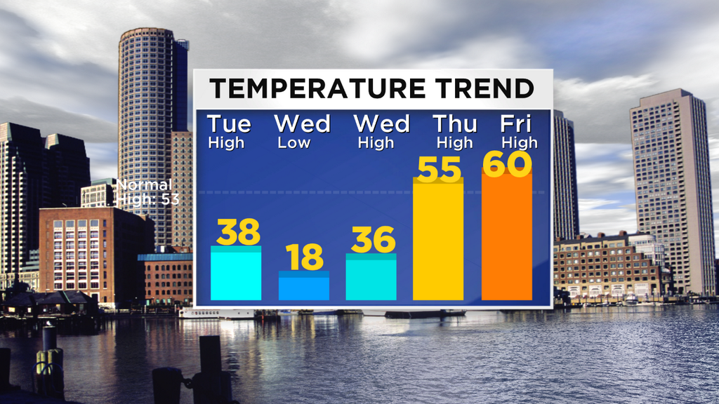
10s to low 20s are expected Tuesday night - I'd call this certifiable crock-pot weather. Plan your comfort food dinner now and get some wood ready for the fireplace. On Wednesday it will be bright and gusty - and once again temperatures around the region will stay in the 30s. But if this sort of thing isn't your mug of beer - hakuna matata. The cold air will be fantastic for ski areas that are already open on the weekends up north - as they'll be able to pump out the powder and increase their bases through Thursday. The annual ski & snowboard expo is coming to Boston this week, and our team will be there every day of its run. More details are here.
RECORD LOW TEMPERATURES FOR NOVEMBER 13TH - 14TH...
BOSTON... 14 /1883/ - 16 /1905/
HARTFORD... 18 /2001/ - 15 /1986/
PROVIDENCE...20 /2001/ - 16 /1905/
WORCESTER... 15 /1986/ - 10 /1986/
However, this blast from our Canadian friends will not last long. As a massive dome of high pressure shifts off to our south, westerly winds will take over across the Northeast. This is a mild flow that will help us climb back into the 50s on Thursday, and approach 60 on Friday! Only in New England. I'm planning on a trip to the golf course to end out the week.
For the overall flow pattern looking ahead - once again the GFS is at complete odds with the ECMWF, and the GEM is out there, too. This has pretty much been the case on a consistent basis in the moderate/long term time frames. And in genera, the GFS has been absolutely demolishing the ECMWF in terms of accuracy. So at this point. I'm leaning toward throwing the ECMWF out the window for this upcoming weekend and beyond and go with the GFS, which has support from its ensemble members, too.
That means a quick, progressive setup for the end of the week - little disturbances riding through the jet, and overall a little more complicated forecast. We may get a batch of showers on Saturday with one impulse, but definitely not a washout. Sunday looks quiet, but another, more potent storm, may wind up heading into Sunday night and Monday. It looks like this one will wind up to our west, which means we'll stay on the mild side and hopefully get some significant rainfall out of it.
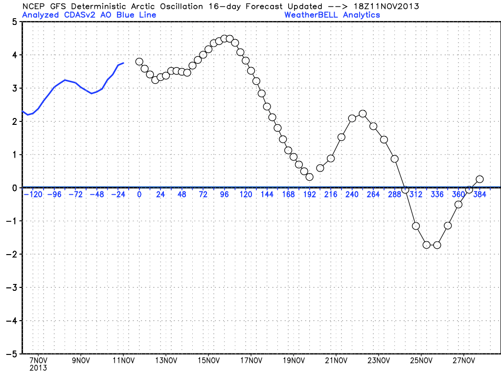
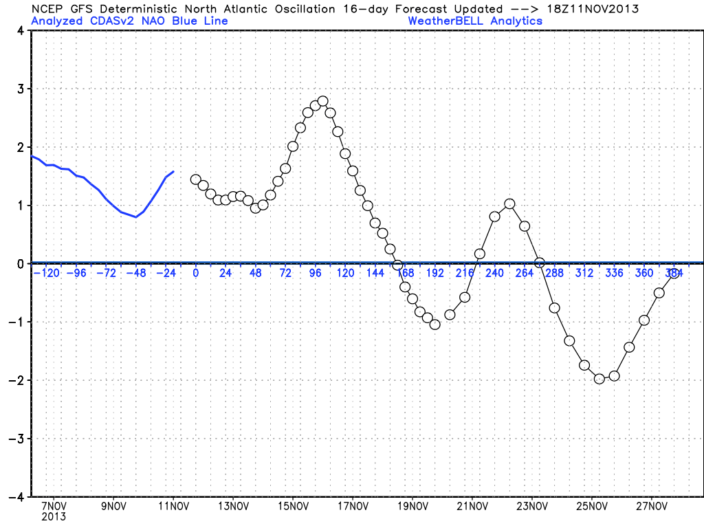
Another trend to keep an eye on is the NAO/AO teleconnections. We're 'stepping down' to a more neutral phase with this cold air outbreak, but after this upcoming mild spell a deeper plunge in the indexes may set up. That would mean Thanksgiving week could end up to be quite a cold one to get you in the holiday spirit. Lots of time to watch, but something to keep in the back of your mind!