Weather Pattern Kicks Into High Gear
Find Eric Fisher on Twitter and Facebook
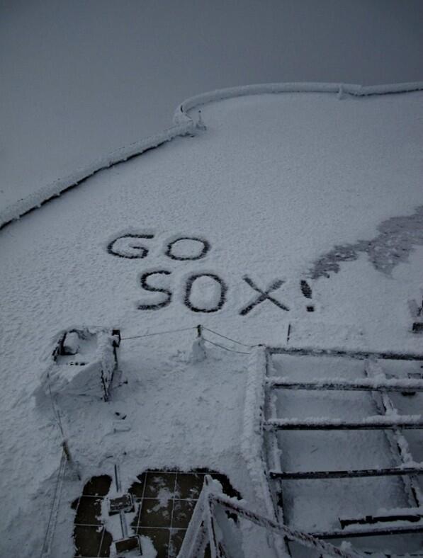
After a very quiet stretch, our weather is finally ramping up as the final minutes of October count down. Some towns reported a few snowflakes today, especially across southern New Hampshire and Vermont. And up on Mt. Washington, they're showing off their Red Sox pride in the new-fallen blanket of ice crystals!
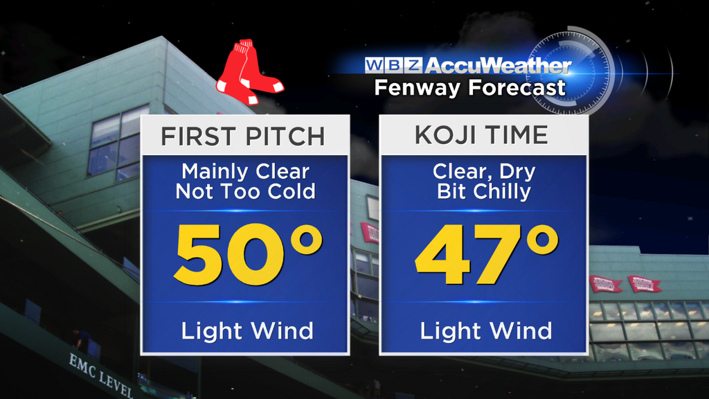
You gotta love it. Even with chilly weather, Fenway Park will be red hot with anticipation of the first World Series Championship at home since September 11th, 1918. The clouds and showers we saw earlier will be gone, and generally expected dry and seasonable weather for the huge Game 6 match-up. No umbrellas needed!
As we move things into Thursday and the inevitable Sox hangover (hopefully a happy one), a strong area of low pressure will be bombing out as it heads to the Great Lakes and will be extending a warm front out east of its center toward our neck of the woods. This storm will be impressive for a few reasons. Firstly, it should drop to a minimum pressure of about 970mb by Friday! Quite low, and enough to generate extremely strong winds across the Northern Great Lakes. It will also bring a blast of mild air across the eastern U.S., and draw up unusually high amounts of moisture from the Gulf of Mexico.
The mild air will start to invade tonight. You can watch it here! These are temperatures at 850mb, or a few thousand feet above sea level (and they're in Celsius).
 850mb Temperature Loop
That mild air will help create an inversion tonight (where temperatures actually increase with height). Since we've got some moisture leftover from today's showers, this should help promote low clouds to redevelop overnight and keep them around during the day tomorrow. So a mainly overcast Thursday is expected, though most of the day will stay dry. Showers will start to creep in from the west during the afternoon, with the highest risk across Worcester County, WMass, and SW NH. Trick-or-treaters may have to dodge some raindrops in those locations, but for now we're expecting mainly dry conditions for Metro Boston and SE Mass. For many towns, this will be the first Halloween in 3 years due to Sandy and Snowtober ruining the fun the past 2 years.
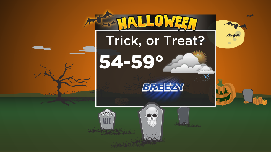
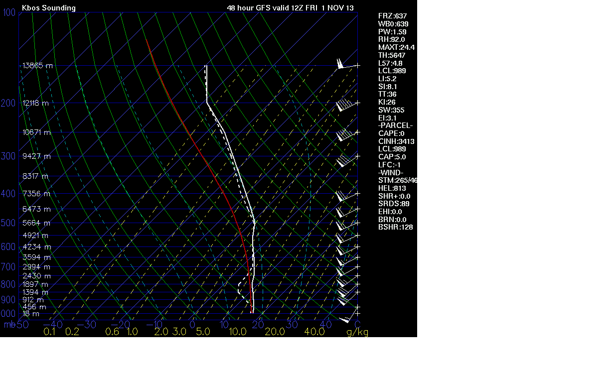
The next ingredient we're watching is the wind. When you've got an area of low pressure that strong and high pressure to the east, you're going to create tight gradient. Our winds will start to get gusty by midday Thursday, with stronger gusts by trick-or-treat time (or a potential Game 7 at Fenway). I'm thinking they will be in the 10-25mph range, which will make it hard to keep jack-o-lanterns lit. At least we won't have to worry about the cold, as temperatures will be in the 55-60º range in the evening. Winds will continue to increase overnight to the 15-40mph range. By the morning, it will be downright wild out. Check out the GFS sounding for Friday morning. You see 50mph+ winds near the surface, with hurricane force winds just a couple thousand feet up!
Friday morning should be windy enough to make umbrellas fairly ineffective, unless you like yours inside out. Lots of leaves will come down, and there could also be scattered downed power lines and trees/limbs. The strongest gusts will be felt across SE Mass and the coastal plain. I wouldn't be surprised to see a 60mph gust or two there. Those winds will stay with us through at least the early afternoon before slackening off. On top of the rain and wind, very mild temperatures will add to the wild feel of the day. Highs will be well into the 60s, and will be warm from the get-go Friday morning.
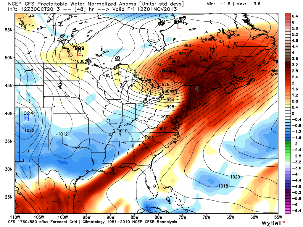
Lastly, you can see the plume of high PWATs (precipitable water values) along the East Coast. Almost like a straw taking a drink of water vapor from the Gulf! This means there is more 'juice' in the atmosphere, so that when rain moves in it will really come down. And we could definitely use it. Most of the area is about 3" below average in terms of rainfall for October.
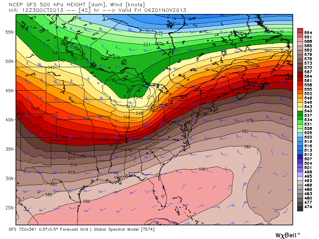
That being said, most of the upper-level energy here is going to head up to our west (similar to what we've seen a lot of recently). So I'd expect most of the heaviest rain to fall there, around New York State and western New England. Here's a look at the 500mb pattern, which shows that strong short-wave heading through the Great Lakes and then off to our NW. That's where the best forcing in the atmosphere will be.
The overall impact for us will be scattered showers/downpours Thursday night through Friday morning. When the front itself approaches, I'd expect a thin band of heavy rain to be along it (where those high PWAT values are). It looks like rain should be long gone by the evening, so drier but still breezy conditions on tap for Friday night.
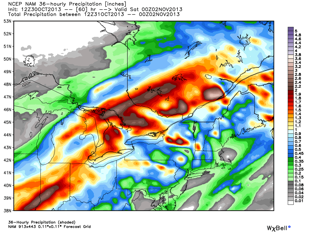
Here are the NAM rainfall totals through Friday night. While they may not be completely accurate, it helps show the idea that heavier rain totals will be off to our west. Locally the least amount of rain will fall across the Cape & Islands, with the higher totals around Metro-West and points farther NW.
Then...the weekend! A secondary cold front will be on the way on Saturday, and we probably won't get a dazzling start to the weekend out of it. For now we'll call it partly sunny and breezy on Saturday with a few showers. We'll also need to keep a close eye on a wave of low pressure forming along the front that will be sitting offshore. Some models of indicated that this may nick the Cape & Islands with rain on Saturday. Nantucket will be most at risk for this, from Friday night through Saturday. We'll have a better idea on where exactly the edge of the rain will set up in the days to come.
The cold air will pour on down Saturday night, and so Sunday is looking quite chilly. Highs should stay in the 40s, and probably just the 30s for higher elevations of Northern New England! I'm sure the ski hounds won't complain much about that. A gusty north wind will make it feel even colder. That same wind may help produce some ocean-effect clouds and showers on the Cape...possibly even ocean-effect snow showers. I'd call it fitting, since Sunday is the first day of Standard Time. We 'Fall Back' at 2am, which means sunset is at a ghastly 4:35pm on Sunday. So if you're going to Gillette for the Patriots game, remember that most of the game will be played in darkness!