Sandy - 1 Year Later
Find Eric Fisher on Twitter and Facebook
A storm no one in this part of the world had seen in quite some time. Sandy has left a big legacy, in both the damage it left behind and its impact on planning for the future. We'll be live this evening from one of Massachusetts most vulnerable areas to hurricanes - the South Coast. Buzzard's Bay is a perfect funnel for storm surge, and hasn't been fully exploited since the 1938 Hurricane (and even that wasn't a worst-case scenario...a little farther to the east would be for the Buzzard's Bay region).
I wanted to put out some resources on MA and hurricanes. There are some useful links here on history, as well as inundation maps that are created by the NHC's 'SLOSH' model and ways you can prepare. If anything, this state lucked out with Sandy. It's a teachable moment that hopefully will leave us better prepared for when the big one hits here. And given enough time, another storm like the 1938 hurricane or Sandy will hit. The best thing you can do is prepare long in advance by looking at inundation maps, having the right supplies, and having a plan long before a storm is bearing down on us.
One of the best things I can encourage is to buy a safe box that is both waterproof and fireproof. I bought one of these when I moved to Atlanta (tornado country). Put wedding photos, any other photos you want to hold onto and transfer them to thumb drives/external hard drives. Keep these in the box, so you'll never have to worry about losing the files. You may also want to keep important documents and insurance information inside (under lock and key of course). It's also a good idea to take updated photos of your home and belongings and put them on a thumb drive. These may come in handy when filing insurance claims afterwards. The goal of all this is to cut down on the chaos after a storm.


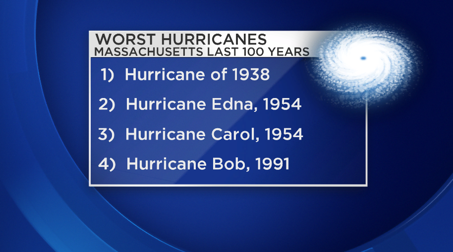
Worst 5 hurricanes in MA history: http://www.mass.gov/eea/agencies/czm/publications/pages/worst-hurricanes.html
Buzzard's Bay has an excellent hurricane related website: http://buzzardsbay.org/hurricane.htm
Inundation maps: http://www.mass.gov/eopss/agencies/mema/hurricane-inundation-maps.html
Interesting little local article on Wareham area: http://wareham-ma.villagesoup.com/p/experts-were-due-for-a-hurricane-prepare-ahead-of-time/139262
Top 5 vulnerable cities (Boston is one of them) http://www.livescience.com/11158-cities-vulnerable-hurricanes.html
Sandy by the numbers: http://www.wunderground.com/blog/JeffMasters/sandy-by-the-numbers-trying-to-comprehend-a-stunning-disaster
New England Sandy roundup: http://www.weather.com/news/hurricane-sandy-new-england-20121028
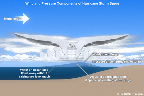
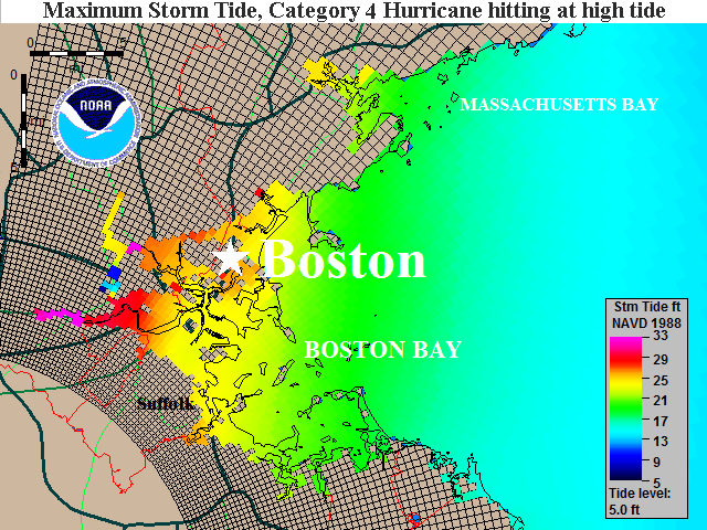
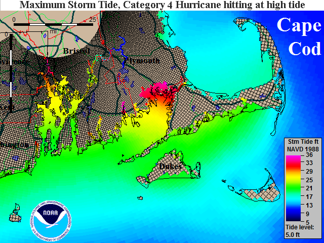
Storm surge can be a bit confusing. There's surge, mean low water level, storm tide, astronomical tides, etc. All the jargon can muddle the message. Bottom line is that surge is the water ON TOP of the normal tide. So if the normal water level on a given day was to the beach, your house was 3' above the beach in elevation, and there was a 5' surge, you'd have 2' of water rushing through your house (and in a hurricane, likely waves crashing on top of that).
Water level maps are the best type to look at. They show you how high the water will actually be in a given neighborhood. When planning, always keep in mind that the water will not be 'static.' It will be flowing, likely with quite a strong current, and will have waves in it. That adds to the level and the destructive power.