Uneventful Weather Ahead
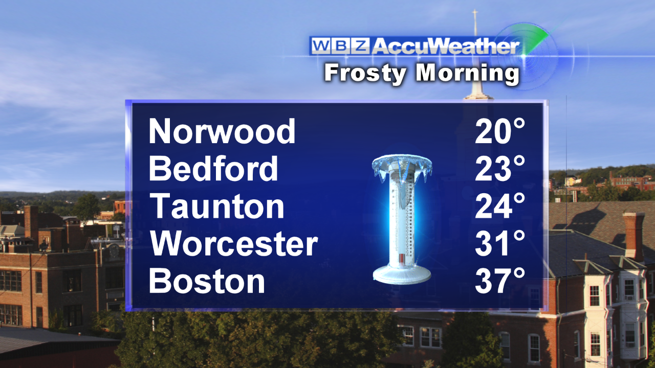 It was another nippy night as most places trumped yesterday morning's chill by a few degrees. Under clear, calm conditions, the setup was ideal for premium radiational cooling. Lowland locations bottomed out closer to 20 degrees like Norwood Airport. Twenties were widespread amidst the frosty terrain making this the coldest morning since April. Boston's 37 degrees was the lowest since April 22nd. The cold will be scoured out by a freshening southwesterly wind which will ramp up to 20-30 mph from late morning through the afternoon. This is all in response to a tightening pressure gradient between a vigorous storm spinning across Ontario and Quebec and a ridge of high pressure to the south of New England. Warmer air will be advecting into the Northeast today but the blustery regime will temper the air by adding a chill so the afternoon highs of 54-58 will feel more like the upper 40s to near 50 or so.
 Aside from the wind and despite the passage of two cold fronts over the next 48-60 hours, the weather will remain rather uneventful for several days to come. One front will cross the region tonight and the next one will follow the same path Monday afternoon. Due to lack of moisture and upper level support, these boundaries will generate nothing more than varying amounts of clouds this afternoon and tonight with another brief batch of patchy clouds possible on Monday. The risk of rain is remote but a sprinkle or light shower cannot be completely ruled out tonight. Most of the action will be taking place across southern Canada and upstate NY and far northern New England. It has been sufficiently cold to produce some snow over the higher elevations this morning such as Mt. Mansfield. The WBZ WeatherBug Network live cam from Stowe has been showing some accumulating snow. A handful of ski resorts have opened this weekend for skiing and riding on limited terrain of manmade and some natural snow. With added clouds and a breeze, it will be much milder tonight with lows in the range of 40-44 followed by a rise back to 55-60 tomorrow with similar highs on Monday. Tomorrow will be a fine day for football as the Patriots host the Dolphins for the 1pm kickoff.
 Looking ahead, a sprawling zone of high pressure from the Great Lakes will ridge southeastward and spill colder air over our region on Tuesday and Wednesday. With almost unlimited sunshine, it will only warm up to near 50 or so on both of those days. After that, the high pressure will shift offshore and the clockwise flow around the system will propel much milder air into the Northeast on Halloween. Expect highs near 60 with a brisk southwesterly wind. It will be settling back to the middle to lower 50s for trick or treat time. Warm air will continue to be pumped in next Friday via a gusty southerly wind with highs surging through the 60s. An approaching cold frontal boundary from the west will create a ribbon of rain and the leading edge of the wet weather will probably arrive in northwestern New England Friday afternoon. With a potential wave of low pressure traveling up the front, there is finally some higher hope for beneficial rain later Friday night and Saturday morning. That would be nice to start off the month of November because October will enter the record books with a whopping rainfall deficit over 3 inches!
One year ago today, Hurricane Sandy was moving through the Bahamas with 80 mph winds. Check out this fascinating animation of the satellite imagery of Sandy from October 23-31. It runs over 3 minutes.
If any new data warrants a revision of the above prognosis, I will post an updated blog this evening. Otherwise, Todd Gutner will publish his thoughts tomorrow morning.
Have a happy and safe weekend.