Nothing Major Looming
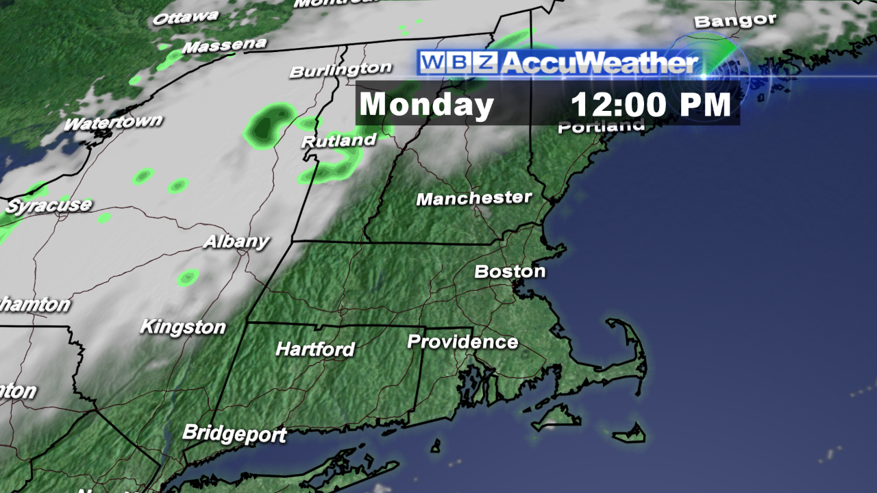 The weekend has been plagued with clouds with only a brief spell of sunshine early Saturday before it became overcast with mist followed by only limited areas of sunshine yesterday. Most areas in southern New England will have the sunniest day of the weekend today. The dense fog in lowland locations especially the river valleys and around bogs, swamps and ponds will burn off by 9am or so. Meantime, a weakening cold front is settling southeastward across upstate NY and northern VT. Its attendant band of clouds and broken swath of showers will be shifting across northern New England during the day but the rain should dry up by midday. The clouds will continue to advance into northwestern MA late this morning then into the rest of northern MA as the afternoon progresses. Following some frosty places in the lowlands early this morning, there will be a big recovery to the middle 60s today with a very light breeze which will be onshore at the coast making it a bit cooler there. The frontal boundary will lose its identity across the region tonight so expect a partly to mostly cloudy sky and much milder conditions with lows in the middle 40s to middle 50s. With the front dissolving in the area tomorrow, the sky will be featuring varying amounts of clouds and some sunshine breaking through. It will warm up to 68-70 except a breeze in from the ocean will cap the numbers in the lower 60s at the coast.
Looking ahead, a storm emerging from the Rockies today will churn across the nation and spin up across the Great Lakes late tomorrow into Wednesday. Its attached frontal boundaries will trigger a shield of mostly cloudy conditions here on Wednesday as moisture tracks from the west and from the south to link up to produce a few showers later Wednesday afternoon and night. The cold front will exit the coastline early Thursday so the last showers will be ending around dawn or so followed by some sunshine as clouds break up and the wind freshens from the west. Temperatures may make a run at 70 again and that is almost 10 degrees above the average for this time of the year. After that, the next upper level disturbance will be lifting northeastward from the Gulf of Mexico with a parcel of rain. The weak storm will pass well south of New England late Thursday night and Friday morning but the northern fringe of its showers may scrape over especially southern England early Friday with clearing to follow Friday afternoon.
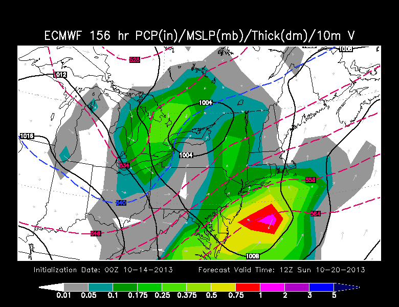 The next weather maker will be more productive as this more energetic impulse in the Jetstream also tracks northeastward from the lower Mississippi Valley to produce a rainy spell Sunday morning. It is too premature to be highly confident right now but the odds favor this system making it unpleasant for the great Head Of The Charles Regatta at least part of Sunday. The associated storm will pass over the Northeast and exit causing some clearing and increasing wind later Sunday. In the wake of the storm, much colder weather will follow the first part of next week.
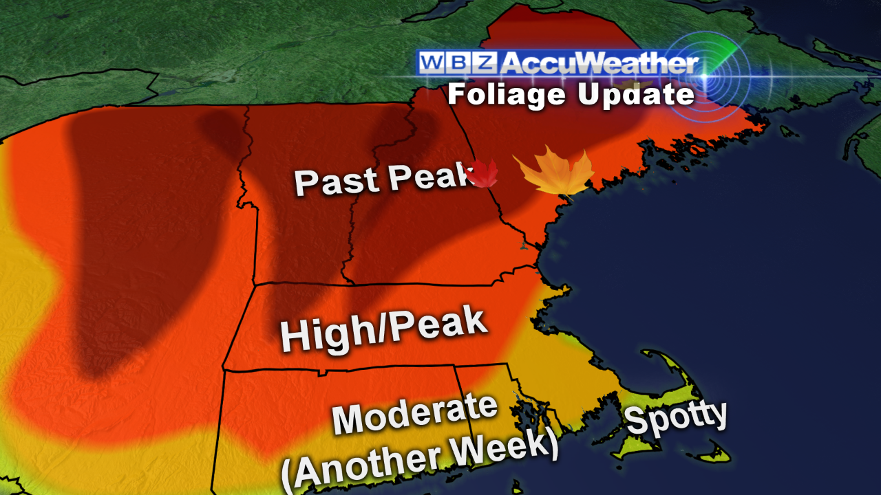 Many of the leaf peepers generally report that the peak fall foliage exists in a band from near Manchester, NH south to near the MA Pike. The color wave is progressing south so there is some nice color developing ahead of the peak wave and there is still some nice residual color left behind in the past peak zone. Keep in mind that there has been considerable leaf drop already in the past peak zone with less leaf and pine needle drop to the south. As you travel around the region, you will undoubtedly be disappointed with the fall foliage extravaganza in places due to muted color while in other locations, single trees to broad areas of forest will dazzle and reward you with vibrant colors. For more detailed info, logon to leaf peepers.
Joe Joyce will be subbing for Eric Fisher later today and he will post his blog this evening.
Make it a great day!