A Rain-Free Weekend!
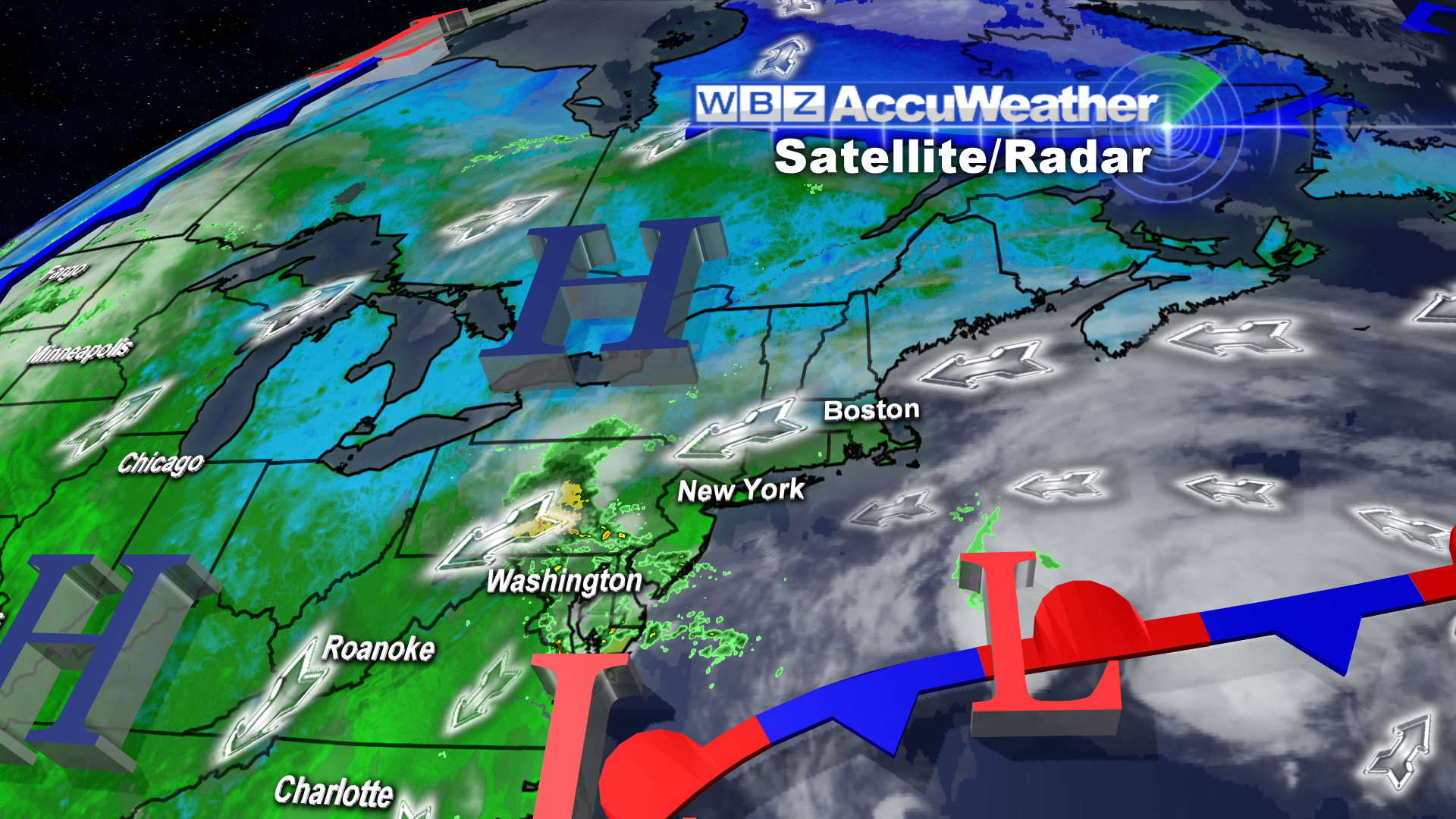 The previously threatening storm has split in two with the primary center still battering the Mid-Atlantic States with rain and wind. A secondary spinoff storm is developing out over the Atlantic and will peel away over the open sea so we're in pretty good shape for several days into next week. That is very good news for everyone that will be traveling this weekend especially to see the fall foliage extravaganza. There will be varying amounts of clouds at various levels of the atmosphere going through tomorrow with the sunniest weather, for the most part, across northern New England. Early this morning, it is warmer on the summit Mt.Washington than it is at many locations surface locations from northern MA northward. This indicates some warm air aloft so all we need is some decent sunshine to boost temperatures to the upper 60s to lower 70s. The best chance for this happening is farther north and west of Boston. Elsewhere middle 60s is attainable with some lower 60s on parts of Cape Cod where the northeast breeze will be most brisk at 10 up to 20 mph on the islands.
High pressure will remain in control for the next 6 days. One center over the Northeast will be overtaken by a second cell of high pressure nosing down from the Canadian Maritimes tomorrow. It will be introduced by a backdoor cold front which has the potential to haul down a parcel of low cloudiness across much of the region tomorrow. With the advection of cooler, moist air from the Northeast, it will definitely be chillier with highs near or slightly over 60. The air will dry out as the high pressure center crests over the area Sunday and Monday so most of the clouds will disappear for much sunnier conditions especially on Sunday. It will still stay cool with the high pressure zone entrenched so I am not expecting much higher than the lower 60s on that day followed by warmer weather on Columbus Day with highs in the upper 60s except lower 60s along the coast. At that time, an approaching cold front will weaken and lose its identity as it is crossing NY. It may send some clouds into the region Monday afternoon but all the rain from this feature should also dry up. That leaves us with the ridge of high pressure in control on Tuesday and Wednesday yielding a sunny to partly cloudy sky. A stronger frontal boundary will push its shield of clouds and showers into the area next Thursday and Friday.
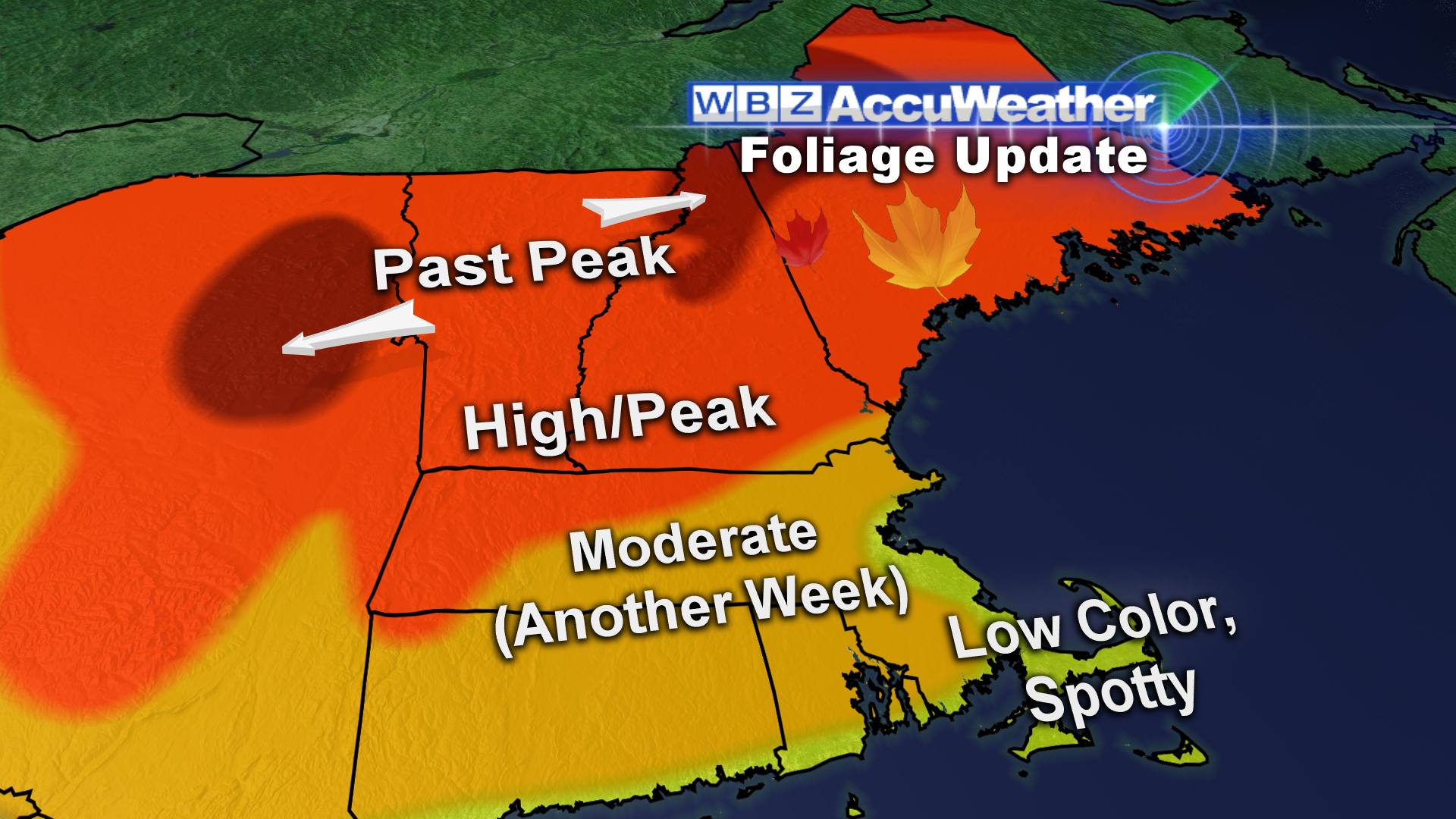 This is the big weekend for leaf peeping. As always, the fall foliage colors are variable across the region ranging from muted color to vibrant color. According to our spotters, some of the maples are spectacular with deep orange and red shading. Peak color exists across much of northern New England into the Berkshires and parts of the higher terrain of Worcester County. It is already past peak across most of the far northern mountains where leaf drop has accelerated with recent rain and wind earlier this week. There is still some nice splashes of residual color on some laggard trees in those past peak zones and there has already been some leaf and pine needle drop even in areas that are just now approaching peak color. Just be prepared for areas where the color is disappointing to areas where there is blazing color. Logon to leaf peepers for more detailed information.
Have a happy and safe holiday weekend.


