The End Is Nigh. Winds of Change Ahead!
Find Eric Fisher on Twitter and Facebook
Oh let me count the ways of how glorious our weather has been lately. It's rained just once in the past 19 days, for starters...and it was at night while most of you slept. Only 5 days have been recorded as 'cloudy' in Boston since the start of September. We've been harvesting a record apple crop. Temperatures have been pleasant. Gorgeous auroras were visible across northern New England last night. And today many towns topped 80 degrees, an always enjoyable feat during the month of October! While not record breaking (today's record high is 88F), it was still well above-average.

Reports from our WBZ Weather Watchers
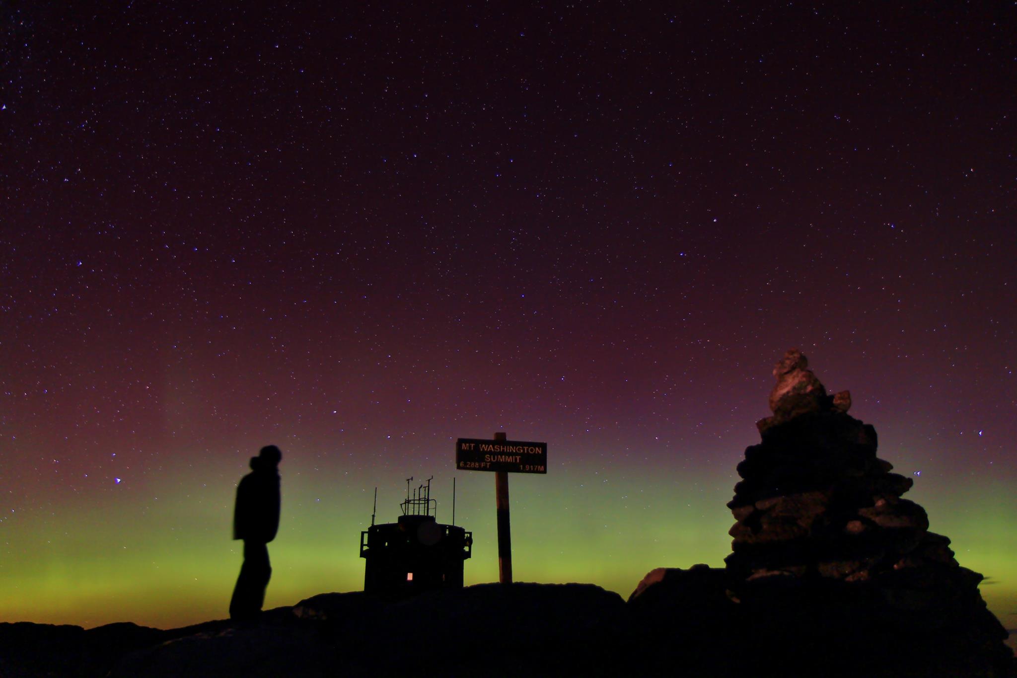
Photo courtesy Ryan Knapp, Mount Washington Observatory
I want you to remember all of this when we start to talking about a change in the weather coming for New England. Because while it won't be *that* bad ahead, we'll definitely start to introduce more clouds and an increasing risk of showers to our forecast. Before that happens, one more day to go! After a pleasant evening with lows in the 51-60F range, we'll see another delightful afternoon on Thursday with sun shining through a deck of high cirrus clouds and temperatures topping out in the mid/upper 70s. Perfect.
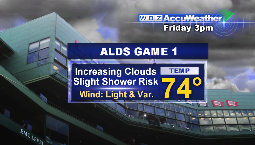
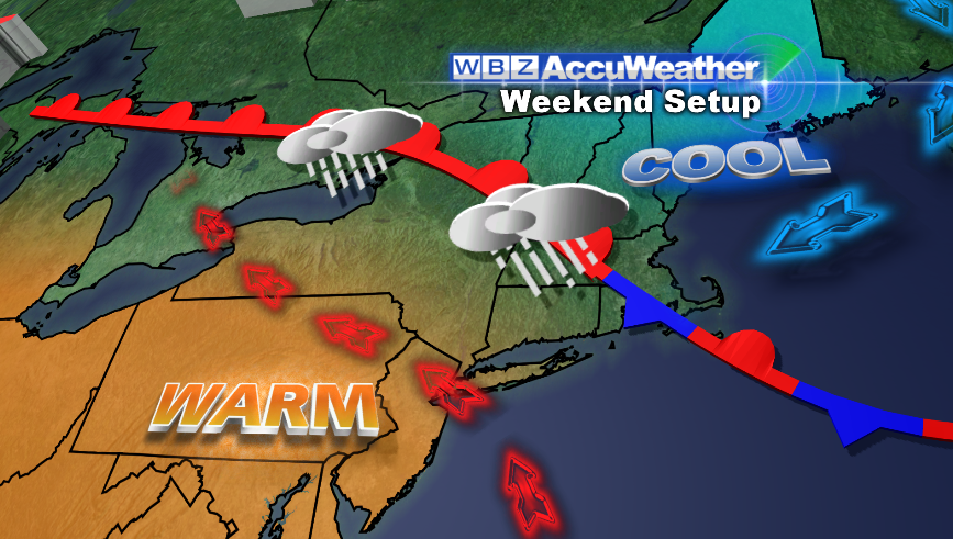
THEN, we get to those changes. A storm system way out in the Plains will be strengthening, producing heavy snowfall and severe weather as it does so in the Nation's Heartland. But even with the storm that far away, we'll see some of its impacts. A warm front will extend all the way to New England by Friday afternoon, separating warm southwesterly winds from cooler onshore winds here at home. That boundary will be a highway for clouds and a few showers stretching away from the parent storm, and so we expect increasing clouds on Friday with perhaps a few showers. Any rain would likely be light and/or short lived, and I don't think it will have a major impact on the Red Sox playoff opener at Fenway Park. Plan on bringing the rain gear to be safe, but don't worry about a postponement! Temperatures will still be mild for this time of year, generally in the low 70s.
The weekend is where it gets tricky. That same boundary will plague the forecast through Saturday and Sunday. It looks like one of those setups where southwestern CT/NYC breaks into the low 80s, while Boston gets mired in the 60s with a stiff onshore breeze. I think that's most likely the case for Saturday. By Sunday afternoon, that front should finally start to lift northward. If that does indeed happen, we'll see an afternoon warmup through the 70s and much more muggy air invade as well.
In short, here are the bullet points for the weekend, as it stands right now:
- A couple showers Friday and into Saturday morning, but generally light amounts and spotty in nature
- Cooler temperatures, but still at or above average
- More dry times than wet times
- Sunday the milder/drier day, esp in the afternoon
I know there are a TON of events this weekend, including weddings, the Red Sox at home, soccer games, the Topsfield Fair, and many others. So we'll keep a close eye on this and let you know if anything changes in the forecast!
After that, we'll actually be monitoring the tropics. Right now there's a very impressive wave, Invest 97L (so-called an 'invest' because the National Hurricane Center is investigating it). The USAF hurricane hunters have been flying around in it, and so better data will start going into the computer models soon. Take a look at it below.
 Tropical satellite loop
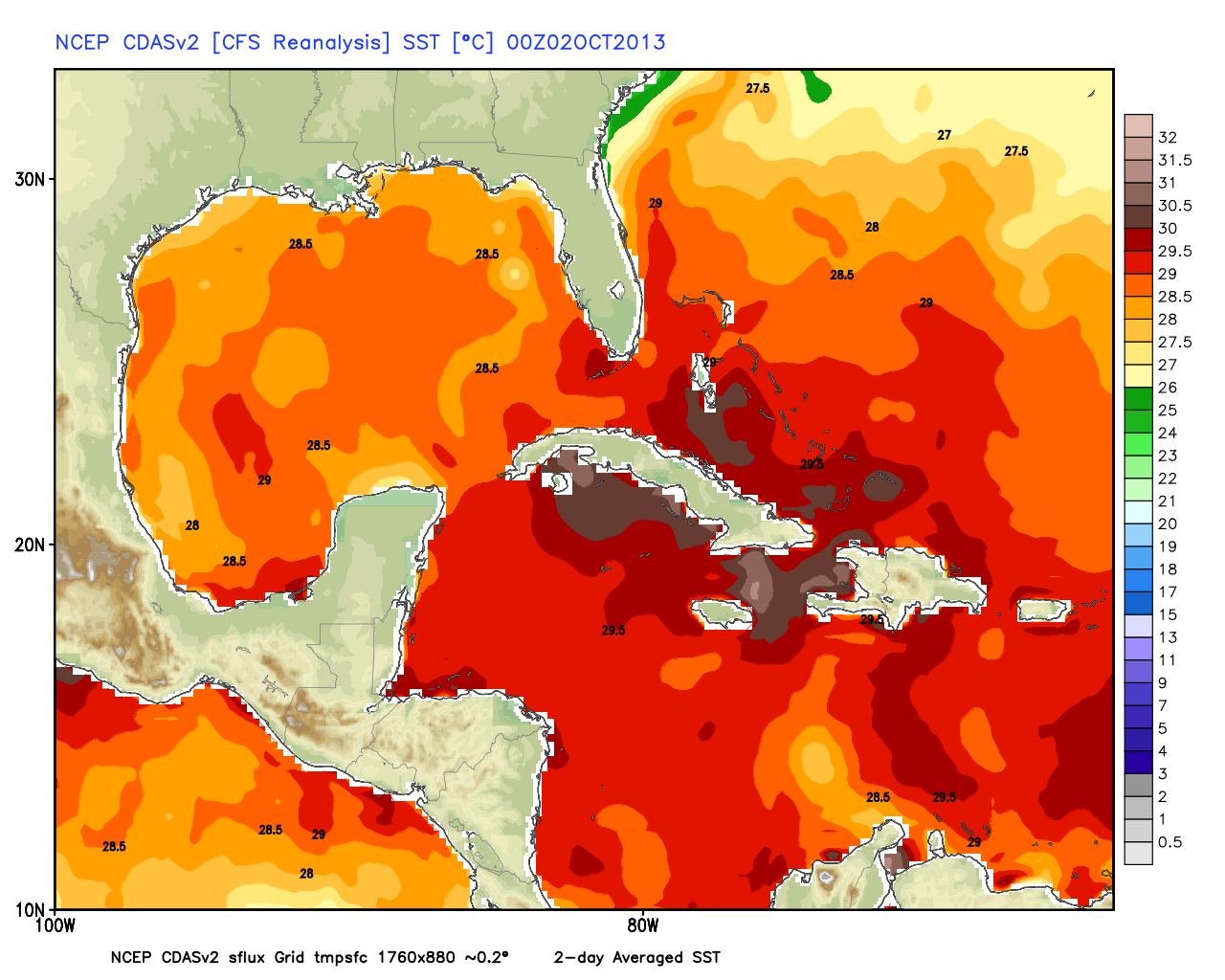
By the time you read this, it may actually already be named by the NHC. If so, it will be 'Karen', and you can always get the latest on the Hurricane Center's website. Most models take this system up into the Gulf Coast this weekend, most likely as a tropical storm or Category 1 hurricane. It will be traveling over very warm water, up to 30º C; and the shear will be marginal enough to allow the system to strengthen.
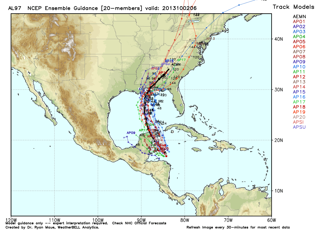
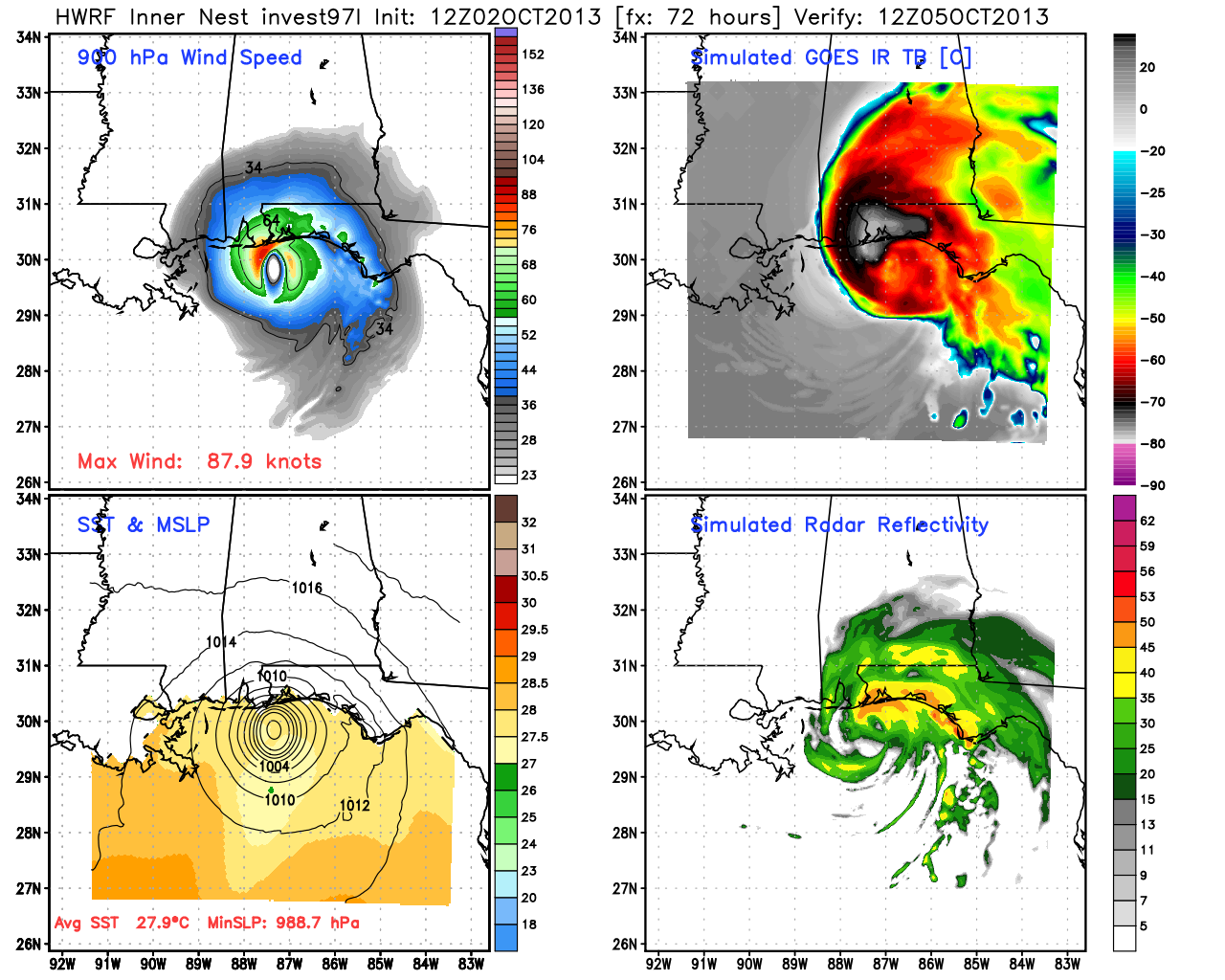
The reason we're keeping a close eye on this is that it could bring us our next shot at significant rainfall. If the potential Karen can organize and gather tropical moisture with it (looking likely), that moisture will become entrained into a cold front marching in our direction. This is the same front from earlier in the blog, that will bring storms & snow to the middle of the country.
Either way, showers will be on the increase in our next of the woods come Monday, and the southerly winds will be gustily blowing more humid air across New England. The only real question mark is - how much will it rain? Will tropical moisture rain itself out over the Appalachians, or ride closer to the coast and give us a good dousing late Monday into Tuesday? We'll be able to work out a lot of those answers in the next 2 days, as we watch Invest 97's progress and get better data into the computer models.
At this point, my fingers are crossed for rain! It's been quite dry and a lot of grasses are turning brown. You've also probably made quite a few watering can trips to keep the fall mums alive. We shall see how it all plays out.
After that, it would appear that high pressure will start to set up residence across southeast Canada, which may keep us in a more onshore regime toward the end of next week. That would mean relatively cool/dry weather. But a long way out with that.
Finally - programming note! We'll be out live with the Mobile Accuweather Lab on Thursday, reporting from the Mt. Monadnock region's beautiful fall foliage. Viewers have been sending in video/photos, and it looks phenomenal. Can't wait to enjoy one last beautiful day outdoors in this excellent streak.