October Here, But Chilly Weather Is Not!
Find Eric Fisher on Twitter and Facebook
September has slipped away, but we will remember it fondly. What a month for weather across New England. It rained just once in the closing 17 days, and most of that rain fell while you were asleep one Saturday night. Only 5 days were classified as 'overcast or mostly cloudy' throughout the whole month. Most areas have yet to see a freeze and so gardens are still growing. Overall, you just couldn't have asked for much more!
Now we move to October...and guess what? It's still looking phenomenal. In fact, we may have a shot at 2-3 days topping 80F to kick off the opening week! The average high right now in Boston is 67 (66 by mid-week), so that's some sweet heat for this time of year. You can't even call it Indian Summer, since it hasn't been cold enough to get that frost for most locations. Just a continuation of pleasant weather.
In the short term, that coastal storm we were watching over the past 8 days or so is just grazing Cape Cod and Nantucket. It's bringing some clouds, and will continue to do so until sometime late tomorrow morning. But the rain looks to stay just offshore. Everyone else is looking at mainly clear skies with some radiation fog developing overnight in the valleys. Any fog will lift by mid-morning tomorrow, and we'll be off to an even nicer day than we had to start the week. Highs will reach the mid 70s inland, upper 60s at the coast before cooling to the low 60s during the late afternoon. Perfect.
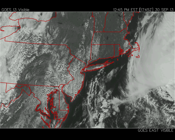
Satellite image of coastal storm grazing the Cape & Islands late on Monday afternoon.
On Wednesday, high pressure will shift off to our south. That will allow for our winds to turn westerly, with little influence from the ocean. With temperatures reaching +14C at 850mb, an unusually warm air mass will send us back into summer. Highs should reach up into the 80s Wednesday afternoon, and that westerly wind trajectory should help keep the sea breezes at bay. So even at the coast, it should be a warm and glorious mid-fall day! The record high in Boston is 88F on Wednesday, so we'll be in the ballpark. Either way, it'll be warm and sunny.
A weak cold front will move through late Wednesday evening, but without much fanfare. Our winds will turn to the NW, bringing dry air into the region and lots of sunshine for Thursday. Highs again will be well above average, reaching t o around 80.
The forecast confidence begins to decrease a bit as we head toward the weekend. A warm front should press in on Friday, bringing increasing clouds and the chance for a few showers. I don't expect a ton of rain with this one, but it will be our next chance for any raindrops, and we could use a few! Temps again will stay well above average, even with the clouds. On Saturday and Sunday the question is all about where that front sets up. If it jumps north and we are in the warm sector, we may have a shot at reaching 80 again. If it sits to our southwest and acts like a backdoor cool front, we may stay in the 60s/low 70s. Still too early to tell for sure, so I wouldn't start making or canceling plans based on the weather just yet. I *do* think the next front will, like the past few, weaken and die out as it approaches us on Monday. So widespread rain doesn't look too likely with that.
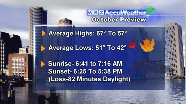
Tuesday brings the start of October, and here's a look at the monthly stats in Boston. Try not to look at the daylight part. The past 2 years have brought major climate events to the region in the 10th month (Sandy, Snowtober)...hopefully this year does not.
The ECMWF says the first 7 days will be warm in the east, and chilly in the west. Overall, I don't see any signal of a major cold air mass visiting us anytime soon. The gardens may keep growing for quite a while! Temperatures should stay at or above average for at least the next 10 days, if not longer.
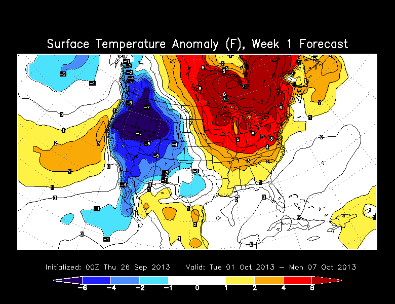
ECMWF weekly forecast for Oct 1-7th, via Wright Weather