Nada This Week, So Let's Talk About Next Week
Find Eric Fisher on Twitter and Facebook

Sunset in Milton Tuesday evening from viewer Claire Lawton
This week can be summed up with one word: nice. Not very technical, but fitting. Our extremely peaceful and enjoyable weather will stretch into at least Saturday, and it doesn't take much to give you the details. Mostly sunny every day with highs in the 60s to near 70, chilly and mostly clear at night with temperatures in the 40s. Seriously, that's it. So head on outside and enjoy! Those temperatures are pretty much in line with average for this part of the season, running just a couple below our average high of 70. (You can check the exact numbers on our 7-Day)
That being said, there are some hints that things could become more complicated by the end of the weekend and into early next week. So I'll spend the time here to break down some of the possibilities!
First off, all of this discussion is coming about because the ECMWF (European) model is producing a pretty impressive coastal storm. Below is the 'operational' run of the model, which tends to do a very good job at forecasting the weather. It received a lot of press after successfully predicting the rare path of Hurricane Sandy last year (note - this possible storm would be absolutely nothing like Sandy).
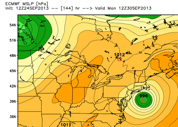
Tuesday 12z ECMWF, showing coastal storm on Monday morning south of New England (Graphics from WeatherBell)
This storm system will have its origins in the Gulf of Mexico, where it will start to organize and gather moisture. Once drifting across the southeast and out into the open waters, the ECMWF is forecasting high pressure to the north of the system to help swing it back toward the coast, along with an approaching trough from the west helping to draw it in.
However, the fly in the ointment is that many other computer models do not agree with this. Here is a look at the GFS (U.S.) model. Out to sea! The GFS has a stronger area of high pressure, and places it farther to the east (with another decently area of high pressure to the west, giving it a channel to track more due northerly).
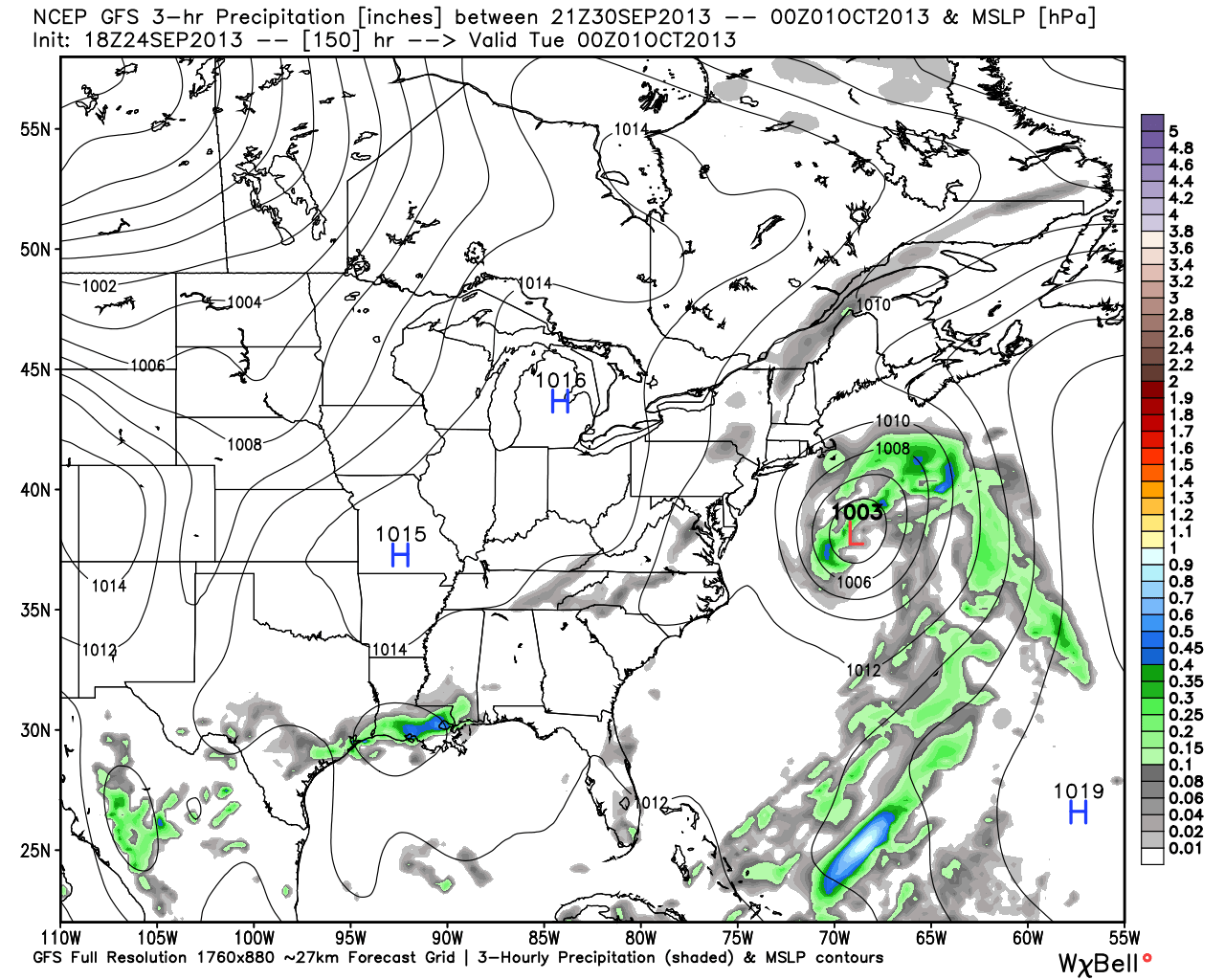
Tuesday 12z GFS model for Monday night - Graphics from WeatherBell
Another way to look at this is to take a peek at the ensembles. Ensembles take the operational run, and then 'tweak' variables in it to see what changes. You can think about the ensembles as a team. When a player is swapped out or its features are changed, the overall performance of the team changes. When you look at the GFS ensembles, pretty much every single one of them is out to sea. Meaning, with all the little tweaks here and there, the end result is still a miss for New England.
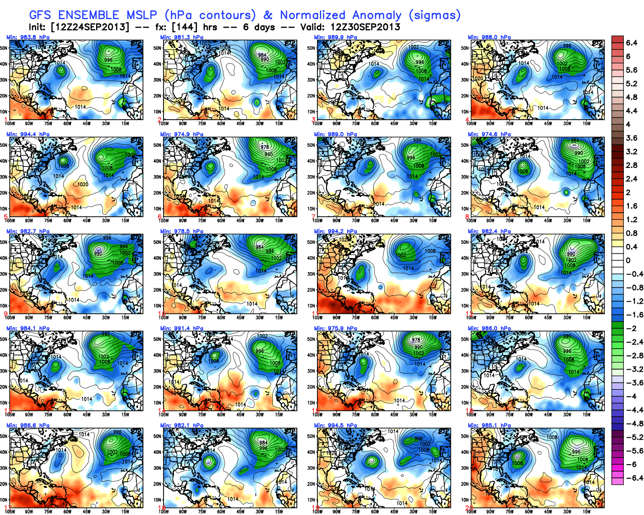
Tuesday 12z GFS ensemble MSLP anomalies for Monday, graphics from WeatherBell
And on top of that, the ECMWF ensembles are also much less bullish than its operational run (although they do still bring in rainfall to the Boston area)
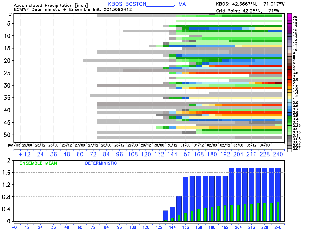
The thing to note on this chart is the green/blue bar graph. The blue bars show the operational forecast, which is for a 1.7" soaking of rain. But the green bars show the ensemble forecast, which is for a much lower 0.75" of rainfall. The idea to take from this is that the 'players' of the ensemble team also lean more out to sea than toward the coast.
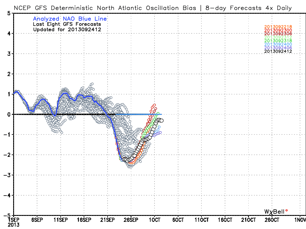
There are two things about the setup that I find pretty interesting. One is that the NAO (North Atlantic Oscillation) is extremely negative right now. Typically, that's one indicator of an increased storm risk for the Northeast. Storms especially tend to form when the NAO is changing, as it will be around Monday. The forecast takes it back in a more (+) direction around Monday/Tuesday.
Also - the ECMWF has been good at 'sniffing out' odd pattern changes or shifts in storm track in recent history. So even though it's an outlier right now, it raises a red flag that we should pay attention to.
When it comes down to it, this isn't likely going to be an extremely serious weather event we have to watch out for. It's just the only game in town! Even if the ECMWF is right, it would lead to a good old fashioned nor'easter type of day on Monday (with clouds rolling in by the second half of Sunday). That means some gusty winds, heavy rainfall, and increased tides (good news on tides is that they will be near the astronomical low point). It may also be a hybrid storm, which would have tropical origins but would likely be transitioning to an extra-tropical cyclone when it gets to our area.
I don't think it would produce anything freaky, like a Snowtober type event or a damaging tropical event. But we'll be keeping a close eye on it since it's the only chance for rain over the next 10 days, and could certainly create some generally nasty weather to start next week. Forecast for now says 'Increasing clouds late Sunday/Monday, with a gusty onshore flow and cool temperatures.'
Stay tuned!


