To the Moon, Alice!
With generally quiet weather this evening, why not take a stroll on this chilly evening with a cup of coffee and take in the night sky? NASA is planning on making it worth your while, with a rocket launch from Wallops Island, VA. This rocket will carry the LADEE (pronounced 'Laddie') - an explorer that will be used to study the moon's atmosphere. Yes, the moon *does* have an atmosphere...just an extremely thin one. Here's a look at the spots that will be in the viewing area after launch, which is schedule to take place at 11:27pm EDT.
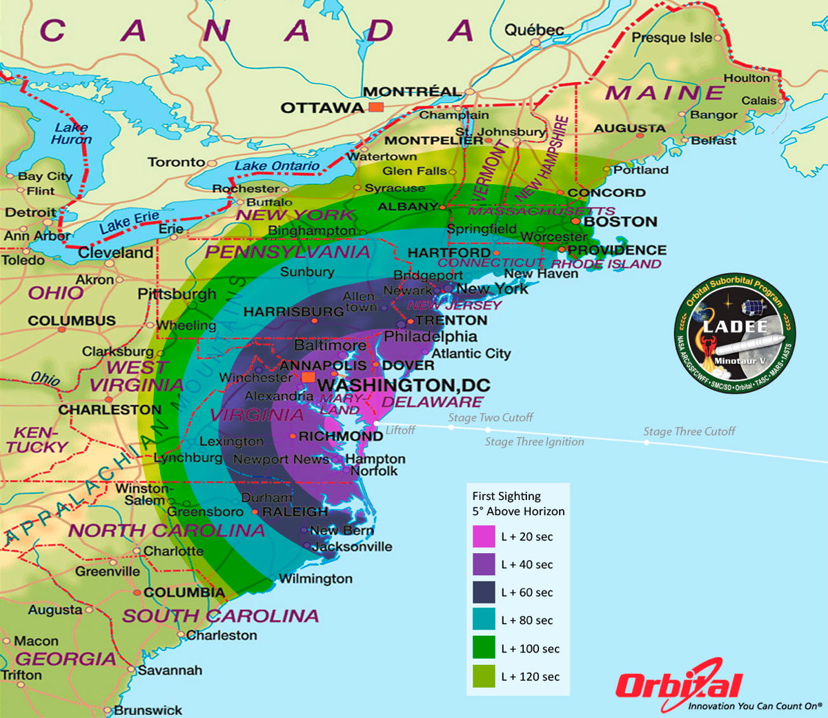
More good news on this - the weather looks great for pretty much the entire viewing area. Clear skies abound along the East Coast! Here in New England, just look to the southeast sky right after launch.
 IR Satellite Loop
http://www.space.com/22673-nasa-ladee-moon-launch-webcast.html
You can read much more about the mission and possible viewing here: http://www.space.com/22673-nasa-ladee-moon-launch-webcast.html
And if you don't want to brave the chill outside, you can sit back with a beverage and watch the whole thing online- >https://twitter.com/Ustream/status/376114556012986369
Now onto our weekend forecast. If you're not into this whole '40s at night, need a jacket to go out' sort of thing yet, you'll enjoy Saturday. After a chilly start we'll warm up nicely on a southwesterly breeze. The only fly in the ointment for Saturday (and it's a very teeny fly) is that a good sheet of cirrus clouds will likely move overhead during the afternoon and evening. A look at the relative humidity at 300mb tells the story. Those high humidity values translate to clouds. Most of them are being produced by storms off to our west, but those will stay west of us. So we'll get a veil of cirrus to dim the sun a little, but otherwise no major complaints.
The front itself will move in Sunday night, bringing mostly cloudy skies and a few showers. It looks like those showers may linger into Sunday morning, but overall we'll salvage the day. Skies should clear from north to south during the morning hours, and most of the region will see a bright and breezy afternoon. Cooler temperatures will prevail, but still seasonable in the low 70s. A big sprawling area of high pressure moves in for Monday with a beautiful start to the work week.
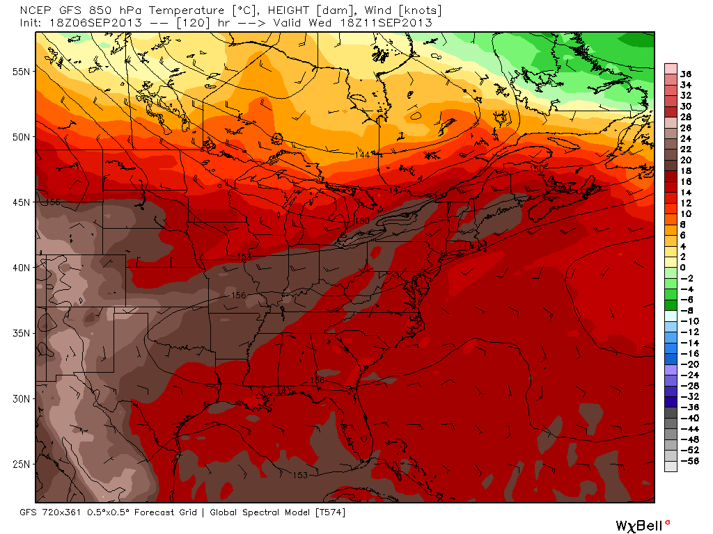
The only other thing worthy of mention tonight is a big change in the pattern for next week. High pressure off the East Coast will build, and the jet stream will pull back northward enough to open the heat floodgates to our south and west. Take a look at the 850mb temps for Wednesday! 850mb is several thousand feet off the surface, and that's where our air tends to mix down from. So we use it as a strong indicator of what our actual temperatures will be around town. With values around +16, we should be well up into the 80s, if this is to verify! I think we certainly have a decent shot at it, and thunderstorms will return to the forecast. So Fall hasn't completely settled in just yet.
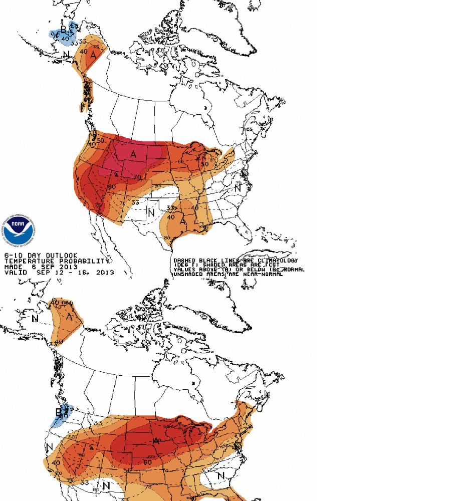
Plus, take a look at the current 6-10 and 8-14 day outlooks from the Climate Prediction Center (CPC). Bottom line here is that barely any below-average temperatures are expected anywhere in the lower 48 for the next 2 weeks. Even if it ends up a little cooler, it's likely that no major bursts of early Arctic air will invade the U.S. in the near term.