Several Inches Of Snow Could Fall On The Coast
BOSTON (CBS) - This is not your typical winter storm on the way tonight and Tuesday morning.
Check: Interactive Radar | Current Conditions | Weather Blogs
A small parcel of energy called a "Clipper" system is diving south out of Canada this morning. This weak low pressure will receive a shot of adrenaline as it reaches the mild ocean just offshore of southern New England.
When this happens we expect that something called a "Norlun Trough" will form. This is a somewhat rare weather occurance where a rather slender band of heavy snow rotates north to south down the New England coastline.
It has some resemblance to a summertime squall line of thunderstorms - it is hard to predict if and where it will form, but when it does, it can mean some very heavy precipitation in very localized spots, typically right along the coast.
In the past, this Norlun Trough has dumped 2-to-4 inch snowfall rates for several hours, bringing travel to a halt with near blizzard-like conditions, but it is highly local.
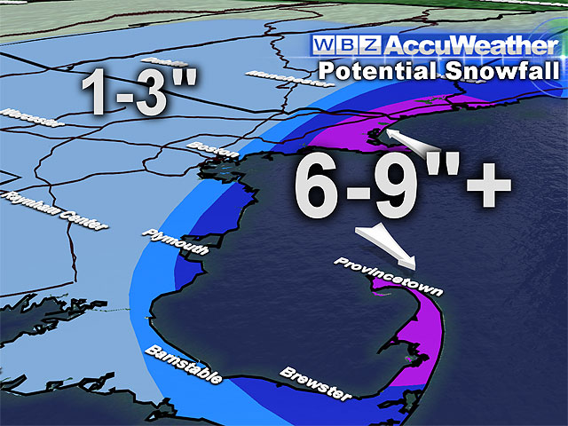
There could very well be 4-to-8 inches or more of snow in one town and next to nothing a few miles away.
So what should we expect this time?
Some light snow will break out this evening over most of southern New England and continue overnight.
For most inland locations this will be a light snow event, just a dusting to 3 inches at best.
Early Tuesday morning though we will be watching for the formation of this heavy band of snow along the coast.
At this point, two coastal spots seem most likely to be affected - first, the seacoast of southern New Hampshire down to Cape Ann and second, the South Shore down to Cape Cod.
There could very well be 4-to-8 inches of snow in some portions of both the North and South Shores, while just a few miles inland snow amounts would drop off significantly.
This will need to be watched very closely and could have huge effects on the Tuesday morning commute.
Thereafter, some of the coldest air in the past few years will pour into New England from Northern Canada.
Daytime highs on Wednesday and Thursday will be in the teens with overnight lows near or below zero.
Another shot of snow may come on Friday, not a major storm, but the potential for additional plowable snow.
You can follow Terry on Twitter at @TerryWBZ.