Midweek Snow
We are waking up to a cloudy sky and even a few showers are falling across extreme southeastern Massachusetts.
Clouds will rule Tuesday with the brightest sky far north and west of Boston due to its distance from the stalled frontal boundary. High temperatures will be a far cry from Monday as we only hang in the upper 30's to lower 40's.
The snow-rain will set in right around midnight as it presses from south to north.
This will be a rain event for the Cape and Islands where totals will range from .25 of an inch- to half-an-inch.
By the time you hit the roads on Wednesday morning, an inch or two of snow may already be on the ground from northern Plymouth and Bristol Counties to points north.
The rain-snow line will slowly push northward toward the Mass Pike.
So, the precipitation will most likely turn to rain-mix for most areas south of the Pike before the system wraps up.
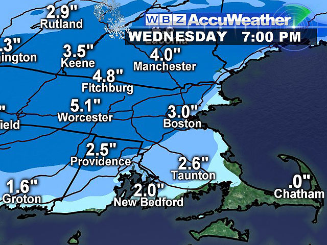
The latest snowfall forecast:
Two-to-4 inches in general with a few isolated amounts of 5-to-6 inches possible, mainly areas north and west of Boston. Portions of Norfolk, Plymouth, and Bristol Counties will receive 1-to-2 inches before transitioning into a rain mix.
A Winter Weather Advisory has been issued for western, central, and northeastern Massachusetts starting at 4 a.m. Wednesday. It will be in effect until 3 p.m. Wednesday. The precipitation will come to a halt on Wednesday evening.
Thursday will be a quiet day with a chance of a late-day flurry as colder air works into New England. Highs will be in the middle 30's to near 40.
Friday will be a day filled with a bright sky accompanied by temps on the cold side with highs in the middle 20's to near the freezing mark. Brrr!
This weekend will be seasonable to start, but it will also be the beginning of a the coldest temperatures so far this season.
There will be a brief warm-up Saturday as highs return to the 40-45 range. It will be partly cloudy to partly sunny. The snow is expected to fall across northern New England along a frontal boundary.
Sunday will be in the middle to upper 30's before taking a downward spiral later in the evening.
It will be partly sunny with a chance of a few flurries or light snow showers.
The Patriots game will include falling temperatures through the 30's along with a breezy northwest wind. It's going to be a cold one so get your blankets, hand warmers, and seat warmers ready-to-go!
Who's ready for some snow?
~Melissa :)