All You Need To Know About Saturday's Snow
BOSTON (CBS) - No doubt this forecast has been a tricky one.
Following the weather models has been like a roller coaster ride over the last few days. The issue is a rapidly deepening storm system passing just south of New England tonight. Models are having are tough time forecasting due to the fact it is developing and blowing up as it passes by our latitude.
CHECK: Interactive Radar | Watches & Warnings | WBZ Weather Blogs | Traffic
The question is how quickly does it develop and how much of its northern fringe do we catch.
This morning once again there has been an adjustment in most of the models. The storm looks as though it will develop into a fairly significant storm a bit quicker, meaning a significant burst of snow in Southern New England tonight.
Light snow will begin as early as midday or early afternoon across the region. Little accumulation is expected during the daylight hours, perhaps a coating to an inch or so.
The intensity will pick up in a big way this evening after 6 p.m. Snowfall rates could exceed an inch an hour between 7 p.m. and 1 a.m. tonight, coming in bands rotating northward over southeastern Massachusetts. Then just as quickly as it started, it will taper off a few hours before sunrise on Sunday.
A wide swath of 4-8" of snow will cover most of Southern New England by Sunday morning. Best chance of seeing higher amounts will be in parts of inland southeastern Massachusetts, a few miles away from the Coast...6-10" is likely in these areas.
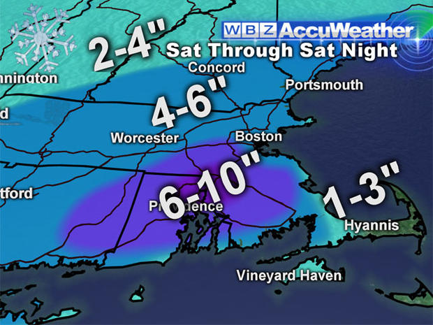
Slight lower amounts will be found farther north in New Hampshire and Vermont, but due to the light and fluffy nature of the snow, a "fluff factor" could make what would be a couple inches accumulate to 4" or so.
That is some good news. For the most part, the snow will be light and fluffy and easily shoveled or plowed.
The exception to this would be along the immediate Coastline from the South Shore down to the Cape where mild winds off the Ocean will actually cause some mixing and keep snow totals a bit lighter.
Over Cape Cod, enough mixing should occur to significantly lower totals to a few sloppy, slushy inches at most.
Winds will be a bit gusty on the immediate Coastline and especially over Cape Cod tonight. Gusts will reach 20-40 mph in those locations. Elsewhere wind will not be a factor and certainly nothing like what happened with our last storm after Christmas.
I'm not too concerned about coastal flooding either, tides are lower than they were a few days ago and due to the quick movement of the storm, only one high tide cycle will be affected, just after midnight tonight.
So if you don't have to travel tonight, don't. Sit back and enjoy the snow. It will be the first significant, plowable snowfall for most in Eastern and Southeastern New England.