Saturday Storm Could Bring 6 Inches Of Snow, Possibly More
BOSTON (CBS) - The final storm of 2012 could be big for some towns.
Check: Interactive Radar | Current Conditions | Weather Blogs
Our latest weather models are projecting the Saturday storm continues to shift slightly closer to the coast of Massachusetts.
Read: Todd Gutner's Storm Forecast
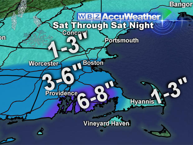
Under this scenario, areas south of the Massachusetts Turnpike, especially in southeastern Mass., could be in for up to 6 inches of snow.
A Winter Storm Watch has been issued for the following counties in Massachusetts: Eastern Norfolk, Eastern Plymouth, Northern Bristol, Southern Bristol, Southern Plymouth, Southern Worcester, Western Norfolk, Western Plymouth.
The snow should start falling Saturday afternoon with the bulk of the storm lasting from 4 p.m. to midnight.
Four-to-five inches are expected in Boston. Communities north and west of the city could get 3-to-6 inches, with 1-to-3 in northern Massachusetts and southern New Hampshire.
South of the Pike, 3-to-6 inches will fall.
Foxboro could get up to 6 inches of snow on the ground before Sunday's Patriots-Dolphins game at Gillette Stadium.
The so-called "jackpot" area of 6-to-8 inches has shifted to the South Shore and inner Cape.
There will be a mix on the rest of the Cape, with 1-to-3 inches of snow on the outer Cape.
You can follow Terry on Twitter at @TerryWBZ.