What Happened With The Snow Forecast?
BOSTON (CBS) - The first storm is always the toughest.
Early season snow events can be extremely difficult to predict for a number of reasons; ocean temperatures are still mild, the ground is not completely frozen and temperatures are typically very near the freezing mark, making predicting precipitation type a nightmare for meteorologists. (Literally, I had nightmares in the days leading up to this storm)
Check: Current Conditions | Weather Maps | Interactive Radar
In the 48 hours before this event, models trended colder and colder, and the snowfall forecast shifted from an elevation event in the hills and mountains to a more widespread accumulation.
In order to get snow to accumulate on the roads near the city of Boston in early November, you really need a lot of things to fall into place just right. The wind direction can't be east or even northeast. It has to be north-northeast, thereby cancelling the effect of the mild ocean temperatures. A shift of 10-to-20 degrees in wind direction can and will change rain to snow. Also you need the snow to fall with a certain intensity, as soon as the precipitation lightens, it tends to melt on contact and many times changes back to rain.
As the storm neared on Wednesday it started to become clear that this nor'easter might just be one of those storms - a rare snow accumulation in early November was coming.
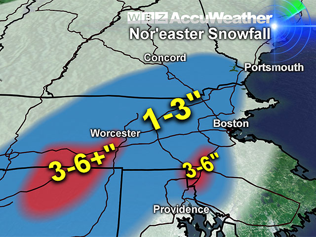
Our weather team was forecasting a general 1-3 inches across most of the interior, with the potential of higher amounts in the elevated areas of Worcester County. The one thing that concerned us was some "banding."
We thought that a heavier band of snow may set up somewhere in southern New England and foul up our snowfall map, but predicting if and where that would happen is nearly impossible.

It wound up happening right on the rain-snow line just to the south and west of Boston in places like Foxboro, Walpole, and Southbridge, areas where we forecasted 1-to-3 inches, got nearly double - up to 6 inches in Foxboro!
Check: Snow Totals
Unfortunately, meteorology is far from an exact science, I have said this many times before and I am sure that I will say it numerous times this winter.
Predicting exact snow amounts for an entire region such as southern New England is truly impossible.
With each and every snow event there is almost certain to be an area or areas where Mother Nature goes rogue and fouls up our nice and neat snowfall forecast map.
I think that for the most part, hearty New Englanders have come to understand the difficulty in predicting snow totals and most times they ready themselves for anything when snow is in the forecast.
But when it comes in early November, and it's the first accumulation of the season, it does add a little extra "shock value."
Driving on snowy roads and brushing snow off the car for the first time can be somewhat shocking even for long time residents of New England.
And considering the snow-less winter we had last year, it is certainly understandable if many were a bit rusty behind the wheel, or if you had absolutely no idea where the shovel and brush were.
At any rate, we got the first one in the books, we made it.
One down and who knows how many to go. Just know that this won't be the last time Mother Nature throws us a curve ball.
It's just a matter of how quickly we pick it up and whether we hit it out of the park or take a big swing and a miss.
You can follow Terry on Twitter at @TerryWBZ.


