The Perfect Storm: Possible Next Week... But Is It Likely?
BOSTON (CBS) - So you may have heard… meteorologists up and down the East Coast are all on heightened alert this week. What has all of our attention? A little storm currently located about 325 miles South of Jamaica.
This storm, which has been named Tropical Storm Sandy, is actually not that far north from South America right now, so what's all the fuss about? Isn't it too late in the year to be thinking about hurricanes? Well, not really.
In fact, the Atlantic Hurricane Season doesn't officially end until November 30th. And it just so happens that the waters off the East Coast and down in the Tropics are much warmer than normal for this time of year. So it isn't all that surprising that we are seeing some late action this year in that region.
What it a bit surprising is that many of our computer models are bringing that storm all the way from just north of South America to the waters offshore of New England in the next 7 days. Granted this is one heck of a voyage, and no doubt there will be numerous atmospheric factors at play that will influence Sandy's ultimate strength for the entire trip.
Let me be clear right off the bat…this storm, IF it were to affect New England, would not arrive until early NEXT week. This is a long time by meteorological standards, and the degree of certainty in a forecast that far out in time is very low. Not to mention, with this particular event, there are even more strong forces at play than normal in our atmosphere.
Among them, a large shift which is occurring in our northern latitudes from what we call a positive NAO (North Atlantic Oscillation) to a negative one - meaning a large block is about to set up shop well to our north, causing a traffic nightmare in our atmosphere. Also, our Jetstream is about to undergo a huge shift, from its normal west to east flow to a huge dip in the Central and Eastern U.S., complicating factors even more.
So, in order for Sandy to have a significant effect on our weather here in New England, the atmosphere has to set up ever so perfectly. First of all, Sandy has to continue to strengthen as it passes over the Caribbean islands of Jamaica, Cuba and eventually the Bahamas. Then, the digging Jetstream has to arrive in just the nick of time, scoop up Sandy and drive her northward. Finally, a last impulse of energy would have to dive into the Jetstream forcing Sandy to pivot and slingshot westward back towards New England.
That is asking a lot, and would undoubtedly be a "perfect storm" of events.
Is this all likely to happen? No. But is it possible? Absolutely.
In fact, we have a history here of similar "perfect" storms unfolding right around the same date in our history. Just last year we had an historic event just before Halloween, several inches of wet snow combined with intense winds to knock out power to thousands for days, cancelling Halloween in several towns.
And 21 years ago, the storm dubbed "The Perfect Storm" occurred on Halloween. Heck, there was even a best-selling book and movie made about that one!
So what are the chances of another historic Halloween event? At this point it remains somewhat of a longshot. However, some of our most trusted weather models continue to concern meteorologists by predicting, on successive model runs, one heck of a storm here early next week.
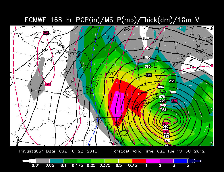
I don't think you have to be a degreed meteorologist to look at this image of the European Model and know that something wicked is just off our Coast next Monday evening:

So what would this mean? If the worst case scenario actually happened here early next week?
What you see in the image above is likely what we call a hybrid storm. In other words it would be Tropical storm or Hurricane Sandy, transitioning to a cold core system, losing its tropical characteristics and becoming something more of an intense nor'easter.
This isn't necessarily good news. Typically when this happens, the strongest winds near the center of the storm weaken a bit, but the entire wind field fans out for several hundred miles, meaning the impacts would be felt over much greater distances. IF this were to happen here next week, it would mean significant Coastal flooding and erosion, intense and damaging winds and a whole lot of rain. It wouldn't be a fast mover either. The impacts would likely be felt for a solid 24-36 hour period, exacerbating the coastal flood and wind damage threat.
And this is why meteorologists are watching Sandy's every move so closely. The stakes are extremely high given the potential with this storm. There will not be a final solution or forecast today or tomorrow. There are just too many factors at play. However I would recommend following forecasts closely all week and at least begin to consider a plan for early next week should our next "Perfect Storm" come together.


