Summer-Like Sunday Likely to Break Records
Today's records go back to 60-70 years in some cases. This shows just how rare an airmass like this is in October. Here are the numbers we are likely to beat today:
Boston 82 (1942), Worcester 84 (1932), Providence 84 (1943) , Hartford 83 (1943), Concord, NH 83 (2001), Portland, ME (1943)
High pressure SW of New England is firmly in control today wrapping in warming light WNW winds which will warm the eastern facing beaches today. Temps in the valleys this AM are in the 40's, with temps in the 60's in the hills. As the suns warms the ground, the air will rise right into the warm air aloft and produce a rapid warm up this morning with temps quickly climbing into the 70's by late morning. As the air mixes down, The warmer air aloft (16 C at 850) will produce highs in the mid 80's. This is a more typical airmass we see in July than October, but it sure is a welcome encore to summer on this Columbus Day Weekend.
Monday will not be as warm as Sunday, but temps with still average 15 degrees above normal with highs topping out near 80. We will be tracking a back door cold front sliding from Canada with building high pressure behind it. As the front passes, winds will shift onshore Tuesday for a wonderful day with cooler temps with 60's at the coast and lwr 70's inland.
The ridge finally breaks down by midweek as an upper level trough begins to shift east. Easterly onshore winds will keep temps in the mid-upper 60's through Wednesday with clouds on the increase ahead of a sub-tropical low which will track up the east coast and eventually into New England. Rain will likely move in early Thursday and become heavy at times with the potential for tropical downpours. Rain will begin to taper to showers by Thursday night.
The trough begins to take on a negative tilt on Friday, with a strong shortwave which will likely help to trigger a few more showers or a thunderstorm into Friday. ..maybe a few late day breaks. By Saturday, a cool pool of air aloft will settle over New England. This will ensure a cooler more seasonal feel to the air in the mid-upper 60's, with drier trend of weather as the low lifts out with increasing sunshine and WSW winds at the surface.
Make sure to check out Jupiter which will be near the full Hunter's Moon the next few evenings. A gorgeous sight. Look to the East at Night as it rises and to the West at Dawn as it sets. It is making it's closest pass to the Earth until 2022 this month. Great Telescope viewing!
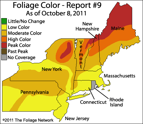
The Latest Fall Foliage Report from the Foliage Network


