Snow/Ice/Rain Take Over
The snow is pressing towards the northeast as I write this blog.
Light snow is already being reported at Springfield and Westfield observation stations.
Watch Melissa's Forecast
The snow will quickly spread across the entire viewing area throughout the duration of morning rush.
Just as quickly as it develops, the temperatures are rising so the snow will changeover to rain for the Cape/Islands and southeast Mass by late morning.
Expect the same transition to rain for Eastern Mass within the 495 corridor by 3pm. The interior will hold onto snow and ice thru the evening. Due to cold air damming, north-central Mass and southern NH will continue to deal with rain/snow/ice thru Tuesday night as well.
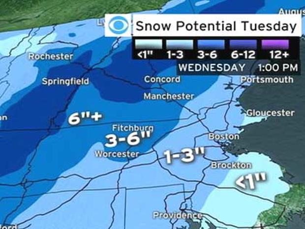
Snow fall amounts will range from <1" for areas south of the Mass Pike...1-3" for areas running diagonal from Portsmouth, NH down along the North Shore thru the 128/495 corridor into Northern RI/CT. ..3-6" for Worcester Co and northward into southern NH...6"+ for areas farther to the north and west. A Winter Weather Advisory is in effect for Eastern and Southeastern Mass while a Winter Storm Warning is in effect for Central and Western Mass along with Southern NH and VT.
An active weather pattern is taking shape. Another storm will affect Southern New England late Thursday night into Friday. This is setting up to be a snow event with the potential of dropping 4-7" of snow by Friday evening.